

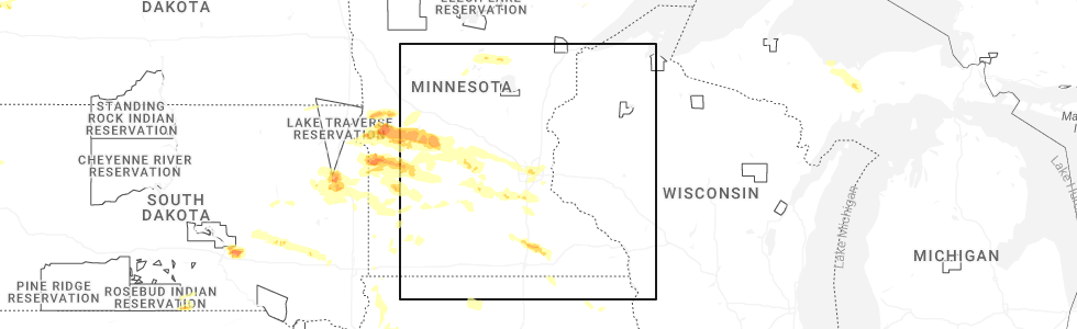
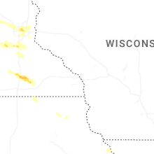
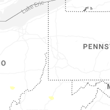
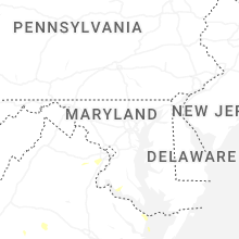
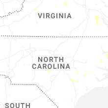
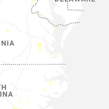
Hail Map for Sunday, July 27, 2025
Number of Impacted Households on 7/27/2025
0
Impacted by 1" or Larger Hail
0
Impacted by 1.75" or Larger Hail
0
Impacted by 2.5" or Larger Hail
Square Miles of Populated Area Impacted on 7/27/2025
0
Impacted by 1" or Larger Hail
0
Impacted by 1.75" or Larger Hail
0
Impacted by 2.5" or Larger Hail

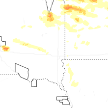

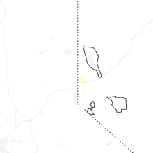
Cities Most Affected by Hail Storms of 7/27/2025
| Hail Size | Demographics of Zip Codes Affected | ||||||
|---|---|---|---|---|---|---|---|
| City | Count | Average | Largest | Pop Density | House Value | Income | Age |
| Watertown, SD | 2 | 2.25 | 2.75 | 78 | $86k | $36.2k | 37.5 |
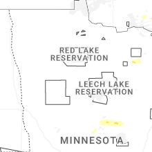
| Minneapolis, MN | 1 | 1.75 | 1.75 | 2385 | $186k | $75.0k | 40.0 |
| Castlewood, SD | 1 | 1.75 | 1.75 | 7 | $60k | $40.1k | 39.1 |
| Hazel, SD | 1 | 1.75 | 1.75 | 4 | $55k | $31.8k | 30.6 |
| Saint Paul, MN | 1 | 1.75 | 1.75 | 6474 | $82k | $29.6k | 29.3 |
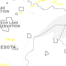
Hail and Wind Damage Spotted on 7/27/2025
Filter by Report Type:Hail ReportsWind Reports
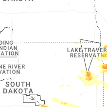
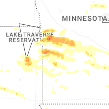
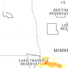
States Impacted
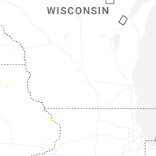
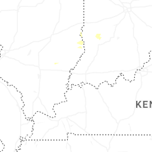
Minnesota, Michigan, South Dakota, Maryland, Ohio, Virginia, North Carolina, West Virginia, Kentucky, Montana, South Carolina, Nevada, IowaMinnesota
| Local Time | Report Details |
|---|---|
| 7:16 AM CDT | Pictures via social media of a couple uprooted and broken trees. time estimated from rada in st. louis county MN, 55.5 miles NNW of Duluth, MN |
| 7:17 AM CDT | Public report relayed via broadcast media partner. picture of an uprooted tree fallen onto the stree in st. louis county MN, 55.9 miles NNW of Duluth, MN |
| 7:53 AM CDT | Quarter sized hail reported near Aitkin, MN, 78.6 miles WSW of Duluth, MN, hail currently falling with not much wind. |
| 7:55 AM CDT | Quarter sized hail reported near Aitkin, MN, 78.3 miles WSW of Duluth, MN |
| 12:03 PM CDT | Quarter sized hail reported near Bellingham, MN, 35.4 miles WNW of Montevideo, MN, mostly nickel sized hail but a few quarters also. |
| 12:37 PM CDT | Report of numerous large trees down between milan and chippewa county road 32. time estimated from rada in chippewa county MN, 14.4 miles NW of Montevideo, MN |
| 12:39 PM CDT | Photos on social media of snapped power pole and several large tree limbs down onto a hous in chippewa county MN, 11.3 miles NW of Montevideo, MN |
| 12:50 PM CDT | Large trees and power lines down near the city of watson. time estimated from rada in chippewa county MN, 6.2 miles NW of Montevideo, MN |
| 4:05 PM CDT | Ndawn station reporting 10 m (~ 33 ft winds in grant county MN, 64.5 miles NNW of Montevideo, MN |
| 4:12 PM CDT | Ping Pong Ball sized hail reported near Herman, MN, 62.7 miles NNW of Montevideo, MN |
| 4:31 PM CDT | Storm damage reported in stevens county MN, 48.1 miles NNW of Montevideo, MN |
| 4:43 PM CDT | Quarter sized hail reported near Chokio, MN, 49.3 miles NNW of Montevideo, MN, relayed via em. |
| 4:45 PM CDT | Quarter sized hail reported near Alberta, MN, 45.7 miles NNW of Montevideo, MN |
| 4:46 PM CDT | Measured at morris municipal airpor in stevens county MN, 43.8 miles NNW of Montevideo, MN |
| 4:46 PM CDT | Quarter sized hail reported near Alberta, MN, 45.7 miles NNW of Montevideo, MN |
| 4:57 PM CDT | Half Dollar sized hail reported near Morris, MN, 45.1 miles NNW of Montevideo, MN |
| 5:04 PM CDT | Power poles down in and near choki in stevens county MN, 48.1 miles NNW of Montevideo, MN |
| 5:18 PM CDT | Multiple large branches dow in pope county MN, 46.4 miles NNE of Montevideo, MN |
| 5:20 PM CDT | Mesonet station mn134 u.s.12 - holloway - mp 27. in swift county MN, 24.5 miles NNW of Montevideo, MN |
| 5:20 PM CDT | Mesonet station mn037 t.h.29 - starbuck - mp 4 in pope county MN, 38 miles NNE of Montevideo, MN |
| 5:25 PM CDT | Mesonet station mn136 t.h.9 - murdock - mp 24. in swift county MN, 30.9 miles NNE of Montevideo, MN |
| 5:35 PM CDT | Mesonet station mn136 t.h.9 - murdock - mp 24. in swift county MN, 30.9 miles NNE of Montevideo, MN |
| 5:40 PM CDT | Grain bins buckled near sunbur in kandiyohi county MN, 36.1 miles NE of Montevideo, MN |
| 5:45 PM CDT | Ping Pong Ball sized hail reported near Dumont, MN, 51 miles NNW of Montevideo, MN |
| 6:18 PM CDT | Quarter sized hail reported near Chokio, MN, 48.1 miles NNW of Montevideo, MN |
| 7:05 PM CDT | Storm damage reported in wright county MN, 30.8 miles WNW of Minneapolis, MN |
| 7:29 PM CDT | Half Dollar sized hail reported near Litchfield, MN, 59.4 miles ENE of Montevideo, MN |
| 7:40 PM CDT | Quarter sized hail reported near Minneapolis, MN, 9.7 miles WNW of Minneapolis, MN |
| 7:47 PM CDT | Half Dollar sized hail reported near Minneapolis, MN, 9.6 miles WNW of Minneapolis, MN, report from mping: half dollar (1.25 in.). |
| 7:48 PM CDT | Asos station kmic crystal a in hennepin county MN, 7.5 miles NNW of Minneapolis, MN |
| 7:51 PM CDT | Golf Ball sized hail reported near Minneapolis, MN, 10 miles WNW of Minneapolis, MN |
| 8:02 PM CDT | Corrects previous non-tstm wnd dmg report from 3 wnw mendota. multiple trees down taking down power lines with time estimated based on rada in hennepin county MN, 5.5 miles SSE of Minneapolis, MN |
| 8:03 PM CDT | Quarter sized hail reported near Saint Paul, MN, 8.4 miles ENE of Minneapolis, MN, report from mping: quarter (1.00 in.). |
| 8:03 PM CDT | Golf Ball sized hail reported near Saint Paul, MN, 5.6 miles E of Minneapolis, MN |
| 8:04 PM CDT | Storm damage reported in ramsey county MN, 5.6 miles ENE of Minneapolis, MN |
| 8:16 PM CDT | Asos station kstp st. paul dwtn a in ramsey county MN, 11.1 miles ESE of Minneapolis, MN |
| 8:20 PM CDT | Quarter sized hail reported near Clarkfield, MN, 19.1 miles S of Montevideo, MN, relayed via fsd. |
| 9:14 PM CDT | Quarter sized hail reported near Lakeville, MN, 22.8 miles S of Minneapolis, MN |
| 9:25 PM CDT | Quarter sized hail reported near Marshall, MN, 34.8 miles S of Montevideo, MN |
| 10:50 PM CDT | Downed trees. time estimated via rada in mower county MN, 42.1 miles NNE of Mason City, IA |
| 11:25 PM CDT | Mesonet station mn144 us 218 at lyle at mp in mower county MN, 31.2 miles NNE of Mason City, IA |
| 11:35 PM CDT | Mesonet station mn144 u.s.218 - lyle - mp in mower county MN, 31.2 miles NNE of Mason City, IA |
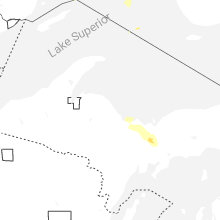
Michigan
| Local Time | Report Details |
|---|---|
| 11:28 AM EDT | Corrects previous tstm wnd gst report from 3 w rock of ages from mesonet to c-man for report source. c-man station roam4 2 w rock of age in lsz263 county MI, 127.8 miles NW of Marquette, MI |
| 2:50 PM EDT | Quarter sized hail reported near Skandia, MI, 19.6 miles SE of Marquette, MI |
| 3:09 PM EDT | Quarter sized hail reported near Chatham, MI, 26.8 miles ESE of Marquette, MI |
| 3:13 PM EDT | Quarter sized hail reported near Chatham, MI, 28.4 miles ESE of Marquette, MI |
| 3:33 PM EDT | Quarter sized hail reported near Munising, MI, 36.5 miles SE of Marquette, MI, from facebook comment with picture showing hail in hand. when asked... replied that a few were quarter sized... but most marble sized. time of occurrence estimated by r |
| 3:38 PM EDT | Quarter sized hail reported near Wetmore, MI, 38.9 miles ESE of Marquette, MI, pea to quarter size hail. |
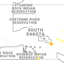
South Dakota
| Local Time | Report Details |
|---|---|
| 11:55 AM CDT | An nws employee estimated up to 60 mph winds between 11:50 pm to 12:00 a in lincoln county SD, 4.1 miles SE of Sioux Falls, SD |
| 6:26 PM CDT | Golf Ball sized hail reported near Watertown, SD, 69.4 miles W of Montevideo, MN |
| 6:40 PM CDT | Baseball sized hail reported near Watertown, SD, 71.3 miles W of Montevideo, MN |
| 6:53 PM CDT | Asos station katy watertown muni a in codington county SD, 70.4 miles W of Montevideo, MN |
| 6:54 PM CDT | Ping Pong Ball sized hail reported near Watertown, SD, 68.9 miles W of Montevideo, MN |
| 7:12 PM CDT | Quarter sized hail reported near Watertown, SD, 68.9 miles W of Montevideo, MN, also reported limbs down. |
| 7:37 PM CDT | Quarter sized hail reported near Winner, SD, 33.6 miles NE of Valentine, NE |
| 7:40 PM CDT | Golf Ball sized hail reported near Hazel, SD, 73.4 miles SE of Aberdeen, SD, radar estimated time. |
| 8:00 PM CDT | Golf Ball sized hail reported near Castlewood, SD, 67.9 miles WSW of Montevideo, MN |
| 8:05 PM CDT | Quarter sized hail reported near Winner, SD, 23.9 miles ENE of Valentine, NE |
| 8:25 PM CDT | Quarter sized hail reported near Castlewood, SD, 66.4 miles WSW of Montevideo, MN |
| 9:55 PM CDT | Storm damage reported in sanborn county SD, 72.5 miles WNW of Sioux Falls, SD |
| 10:38 PM CDT | A personal weather station southeast of canova recorded a 62 mph wind gusts. time estimated via rada in mccook county SD, 41.7 miles WNW of Sioux Falls, SD |
| 11:06 PM CDT | Sddot site near montrose recorded a 59 mph wind gus in mccook county SD, 22.7 miles WNW of Sioux Falls, SD |
| 11:49 PM CDT | A personal weather station near harrisburg... sd recorded a 60 mph wind gus in lincoln county SD, 6.7 miles S of Sioux Falls, SD |
| 11:52 PM CDT | A personal weather station near harrisburg recorded a 65 mph wind gus in lincoln county SD, 7.6 miles SSE of Sioux Falls, SD |
| 11:55 PM CDT | Corrects previous tstm wnd gst report from 4 se sioux falls. an nws employee estimated up to 60 mph winds between 11:50 pm to 12:00 a in lincoln county SD, 4.1 miles SE of Sioux Falls, SD |
| 1:36 AM CDT | An sddot in north sioux city recorded a 59 mph wind gus in union county SD, 68 miles W of Storm Lake, IA |
Maryland
| Local Time | Report Details |
|---|---|
| 1:38 PM EDT | Report of trees down along the 800 block of atlantic st se and 400 block of brandywine st s in district of columb county DC, 37.8 miles SSW of Baltimore, MD |
| 1:56 PM EDT | Multiple trees blew down on md-210 indian head highway near fort washington roa in prince georges county MD, 43.1 miles SSW of Baltimore, MD |
| 2:00 PM EDT | Report of a tree on a house west of waldorf on pimpernel drive in charles county MD, 49.6 miles SSW of Baltimore, MD |
| 2:32 PM EDT | Corrects previous tstm wnd dmg report from stevensville. tree down on walker road at whispering cour in queen anne's county MD, 25.4 miles SE of Baltimore, MD |
| 2:32 PM EDT | Tree down on walker road at whispering cour in queen anne's county MD, 25.4 miles SE of Baltimore, MD |
| 2:47 PM EDT | Numerous reports of trees and power lines down across the cit in calvert county MD, 51.1 miles S of Baltimore, MD |
| 2:55 PM EDT | Tree down on route 50 at bay acres driv in talbot county MD, 49.8 miles SE of Baltimore, MD |
| 2:58 PM EDT | Trees blew down between port tobacco and bel alton... including on md-6 port tobacco road east of rose hill roa in charles county MD, 61 miles SSW of Baltimore, MD |
| 2:58 PM EDT | Numerous reports of trees and power lines down across the cit in calvert county MD, 56.9 miles S of Baltimore, MD |
| 2:59 PM EDT | Report of a tree on a house west of waldorf on pimpernel drive in charles county MD, 49.6 miles SSW of Baltimore, MD |
| 3:14 PM EDT | Wind gusts of up to 57 knots (66 mph) were measured by the cobb point weatherflow sensor (xcob) between 3:14 and 3:29 p in anz537 county MD, 68.2 miles NE of Richmond, VA |
| 3:24 PM EDT | Wind gusts of up to 56 knots (64 mph) were measured by the cove point nos sensor (covm2) between 3:24 and 3:42 p in anz533 county MD, 62.6 miles S of Baltimore, MD |
| 3:25 PM EDT | Numerous trees blew down in southern calvert count in calvert county MD, 61.3 miles S of Baltimore, MD |
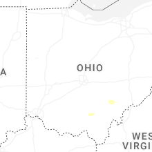
Ohio
| Local Time | Report Details |
|---|---|
| 2:22 PM EDT | Several large branches were downed along town highway 34a near white oak roa in fayette county OH, 26 miles SW of Columbus, OH |
| 6:05 PM EDT | Tree and lines down near intersection of county road 123 and private drive 142. time estimated from rada in lawrence county OH, 44.4 miles W of Charleston, WV |
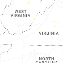
Virginia
| Local Time | Report Details |
|---|---|
| 2:22 PM EDT | Microburst damage with trees down in neighborhood on caisson court in prince william county VA, 56.9 miles SW of Baltimore, MD |
| 2:30 PM EDT | Trees blew down near the intersection of cloverdale road and carson driv in prince william county VA, 60 miles SW of Baltimore, MD |
| 2:32 PM EDT | Tree reported down on road along route 1 in dumfries in prince william county VA, 61.9 miles SW of Baltimore, MD |
| 2:38 PM EDT | Trees blew down near the intersection of marie drive and mary jane driv in prince william county VA, 63.2 miles SW of Baltimore, MD |
| 3:50 PM EDT | Scattered tree damage over portions of southern madison county. a bit more concentrated along south blue ridge turnpik in madison county VA, 62.2 miles NNW of Richmond, VA |
| 3:50 PM EDT | Trees down near the rapidan dam in orange county VA, 60.1 miles NNW of Richmond, VA |
| 3:57 PM EDT | Trees reported down on elys ford road near bullock roa in spotsylvania county VA, 56.3 miles N of Richmond, VA |
| 4:00 PM EDT | 911 call center reported trees down along stony point road near burnley station road. time matched by rada in albemarle county VA, 57.9 miles NW of Richmond, VA |
| 4:00 PM EDT | Tree down on mount holly road. time estimate in westmoreland county VA, 68.5 miles NE of Richmond, VA |
| 4:06 PM EDT | Trees blew down near hamilton and hughesville... including on va-848 holmes mill roa in loudoun county VA, 57.7 miles WSW of Baltimore, MD |
| 4:12 PM EDT | Report of trees down along cox mill road and mallorys ford road in orange county VA, 52.1 miles NNW of Richmond, VA |
| 4:14 PM EDT | Multiple trees down in callao. time estimate in northumberland county VA, 67.9 miles ENE of Richmond, VA |
| 4:25 PM EDT | Tree blocking havelock rd in richmond county. time estimated from rada in richmond county VA, 56.9 miles NE of Richmond, VA |
| 4:30 PM EDT | Multiple trees down in louisa in addition to one downed power line. time estimate in louisa county VA, 40.4 miles NNW of Richmond, VA |
| 4:30 PM EDT | Trees blew down along va-632 south roxbury mills roa in spotsylvania county VA, 45.2 miles N of Richmond, VA |
| 4:58 PM EDT | Tree down in the roadway on va-3 in richmond count in richmond county VA, 61.6 miles ENE of Richmond, VA |
| 5:08 PM EDT | Report of trees down along red hill school road/route 760 to the east of taylors gap roa in albemarle county VA, 62.2 miles WNW of Richmond, VA |
| 5:11 PM EDT | Tree down blocking the road on sr 715 near the town of green bay. time estimated from rada in hanover county VA, 32.2 miles N of Richmond, VA |
| 5:15 PM EDT | Multiple large trees down at 14490 new found rd. time estimated from rada in hanover county VA, 22.5 miles NNE of Richmond, VA |
| 5:20 PM EDT | Tree down in the road on us-1 north of doswel in caroline county VA, 29.1 miles NNE of Richmond, VA |
| 5:30 PM EDT | A tree and powerlines down in the roadway near the intersection of ashland rd and cedar ln in hanover county. time estimated from rada in hanover county VA, 17.2 miles NNE of Richmond, VA |
| 5:30 PM EDT | Multiple trees down on dobby creek rd and paynes landing rd in fluvanna county. time estimate in fluvanna county VA, 47 miles WNW of Richmond, VA |
| 5:32 PM EDT | A report of trees down along langhorne road/route 626 near rock castle cree in albemarle county VA, 53.9 miles WNW of Richmond, VA |
| 5:35 PM EDT | Multiple trees down on west river rd in fluvanna county. time estimate in fluvanna county VA, 44.6 miles WNW of Richmond, VA |
| 5:35 PM EDT | A tree was reported down along tillman lane... not far from rockfish river roa in nelson county VA, 60.6 miles WNW of Richmond, VA |
| 5:35 PM EDT | Tree down on a powerline on james madison hwy in fluvanna county. time estimate in fluvanna county VA, 38.9 miles WNW of Richmond, VA |
| 5:35 PM EDT | Trees and wires blew down in the 2100 block of va-693 salem road causing a fir in nelson county VA, 60.8 miles WNW of Richmond, VA |
| 5:37 PM EDT | Large tree on a house on the 7700 block of wall grove ct. time estimate in hanover county VA, 18.3 miles ENE of Richmond, VA |
| 5:37 PM EDT | A tree was reported down around the 1000 block of james river roa in albemarle county VA, 51.8 miles WNW of Richmond, VA |
| 5:40 PM EDT | Tree down in the road near intersection of willis rd and ark rd in gloucester county. time estimate in gloucester county VA, 54.7 miles NNW of Virginia Beach, VA |
| 5:40 PM EDT | Portion of the rd blocked on rt 1032 in goochland county due to a tree down. time estimate in goochland county VA, 9.9 miles NNW of Richmond, VA |
| 5:40 PM EDT | Tree down on pemberton road near i-64 in henrico count in henrico county VA, 9.8 miles NNE of Richmond, VA |
| 5:40 PM EDT | Part of i-295 is blocked due to a tree down in the roadway in henrico county near mm 4 in henrico county VA, 15.8 miles NE of Richmond, VA |
| 6:15 PM EDT | Tree down in roadway on barnetts road near wayside road. time estimate in charles city county VA, 28.5 miles ESE of Richmond, VA |
| 6:25 PM EDT | Trees down around disputanta. time estimate in prince george county VA, 35.2 miles SE of Richmond, VA |
| 6:30 PM EDT | Large tree down on oak lane. time estimate in powhatan county VA, 6 miles W of Richmond, VA |
| 6:30 PM EDT | Tree down on cook rd in powhatan county. time estimate in powhatan county VA, 22.5 miles W of Richmond, VA |
| 6:30 PM EDT | Tree down on roxbury rd near barnetts rd in charles city count in charles city county VA, 28.3 miles E of Richmond, VA |
| 6:43 PM EDT | Tree down blocking braxton ridge roa in amherst county VA, 55.9 miles ENE of Roanoke, VA |
| 6:55 PM EDT | Tree down blocking izaak walton roa in amherst county VA, 49.9 miles ENE of Roanoke, VA |
| 6:55 PM EDT | Corrects time of damage. tree down blocking lowe stree in botetourt county VA, 22 miles NE of Roanoke, VA |
| 6:57 PM EDT | Tree blown down on partridge creek road blocking entire roa in amherst county VA, 51.7 miles ENE of Roanoke, VA |
| 6:57 PM EDT | Tree down on kings road partially blocking i in amherst county VA, 45.2 miles ENE of Roanoke, VA |
| 7:03 PM EDT | Tree knocked down along smith st and rolfe hwy resulting in lane closures. time estimated from rada in surry county VA, 50.6 miles SE of Richmond, VA |
| 7:05 PM EDT | Tree down on holly farms rd near dutchtown rd in nottoway county. time estimate in nottoway county VA, 32.4 miles WSW of Richmond, VA |
| 7:25 PM EDT | Several reports of trees and powerlines down across the count in southampton county VA, 51.9 miles W of Virginia Beach, VA |
| 7:28 PM EDT | Tree down near krantzs corner r in bedford county VA, 28.3 miles E of Roanoke, VA |
| 7:30 PM EDT | Tree down near the intersection of indian trail and kings fork rd in suffolk. time estimate in city of suffolk county VA, 35 miles W of Virginia Beach, VA |
| 7:40 PM EDT | Tree down on head of river rd in chesapeake. time estimate in city of chesapeake county VA, 10.6 miles SSW of Virginia Beach, VA |
| 7:45 PM EDT | Tree knocked down along monroe rd near delaware rd resulting in lane closures. time estimated from rada in southampton county VA, 51.9 miles W of Virginia Beach, VA |
North Carolina
| Local Time | Report Details |
|---|---|
| 3:00 PM EDT | Tree down on a powerline on nc 168 in barco. time estimate in currituck county NC, 25.6 miles S of Virginia Beach, VA |
| 3:53 PM EDT | Power lines reported down along tyler road in kinsto in lenoir county NC, 66.8 miles ESE of Raleigh, NC |
| 4:15 PM EDT | Anchored outdoor furniture ripped out of the groun in craven county NC, 76.6 miles NNE of Wilmington, NC |
| 5:00 PM EDT | Craven county 911 center reported power line damage in james cit in craven county NC, 78.2 miles NE of Wilmington, NC |
| 7:43 PM EDT | 1 tree down at us 1 and main s in moore county NC, 63.4 miles SW of Raleigh, NC |
| 8:03 PM EDT | Multiple trees down in 2300 block of white cross r in orange county NC, 31.4 miles WNW of Raleigh, NC |
| 8:07 PM EDT | One tree down at jones ferry rd and damascus church r in orange county NC, 27.7 miles WNW of Raleigh, NC |
| 8:12 PM EDT | One tree down in 200 block of s main s in montgomery county NC, 61.7 miles E of Charlotte, NC |
| 8:23 PM EDT | One tree down in 600 block of morgan creek r in orange county NC, 24.2 miles WNW of Raleigh, NC |
| 8:45 PM EDT | 1 tree down at martin rd and mill r in moore county NC, 66 miles E of Charlotte, NC |
| 9:42 PM EDT | 1 tree down at us 1 and quail ridge d in lee county NC, 43.3 miles SW of Raleigh, NC |
| 9:52 PM EDT | Duke energy reported fallen trees or powerlines damaging their equipment... causing power outage in lee county NC, 42.9 miles SW of Raleigh, NC |
West Virginia
| Local Time | Report Details |
|---|---|
| 3:35 PM EDT | Tree down reported on pringle tree park road. time estimated from rada in upshur county WV, 21.8 miles WNW of Elkins, WV |
| 3:45 PM EDT | Large tree down near intersection of ray young rd and alexander rd. time estimated from rada in upshur county WV, 24.7 miles WSW of Elkins, WV |
| 4:30 PM EDT | Report of a tree and lines down across trace fork road south of sandyville. time estimated from rada in jackson county WV, 36.5 miles N of Charleston, WV |
| 4:35 PM EDT | Tree reported down across the railroad tracks along ravenswood road... near the little sandy creek bridge. time estimated from rada in jackson county WV, 44.6 miles N of Charleston, WV |
| 5:15 PM EDT | Tree and lines down across clendenin creek rd... a half mile from wv 34. time estimated from rada in putnam county WV, 20.5 miles NNW of Charleston, WV |
| 5:40 PM EDT | Tree down on johns fork road. time estimated from rada in kanawha county WV, 17.2 miles NE of Charleston, WV |
| 6:25 PM EDT | Tree down near intersection of fields creek rd and haven ln. time estimated from rada in kanawha county WV, 11.3 miles SSE of Charleston, WV |
| 7:15 PM EDT | Tree reported down on south sandbranch road... time estimated from rada in raleigh county WV, 39.9 miles SSE of Charleston, WV |
Kentucky
| Local Time | Report Details |
|---|---|
| 5:45 PM EDT | Tree reported down on wildcat lane. time estimated from rada in greenup county KY, 65.8 miles W of Charleston, WV |
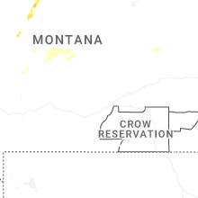
Montana
| Local Time | Report Details |
|---|---|
| 7:41 PM MDT | Quarter sized hail reported near Sunburst, MT, 101.7 miles NNW of Great Falls, MT, report from mping: quarter (1.00 in.). |
| 7:55 PM MDT | Quarter sized hail reported near Harlowton, MT, 81.1 miles NE of Bozeman, MT |
| 8:00 PM MDT | Mesonet station gw5346 devon three wes in toole county MT, 67.4 miles N of Great Falls, MT |
| 8:50 PM MDT | Mesonet station gw2412 hill 2s in liberty county MT, 70 miles WNW of Havre, MT |
| 9:03 PM MDT | Mesonet station gw0718 joplin 25nn in liberty county MT, 61.8 miles WNW of Havre, MT |
South Carolina
| Local Time | Report Details |
|---|---|
| 10:16 PM EDT | Chesterfield county dispatch reports trees down on wamble hill rd near the intersection of jerico rd. time estimated from rada in chesterfield county SC, 50.8 miles SE of Charlotte, NC |
Nevada
| Local Time | Report Details |
|---|---|
| 8:30 PM PDT | Quarter sized hail reported near Reno, NV, 1.9 miles SW of Reno, NV, public reported 1 inch hail verified with a photo. |
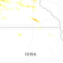
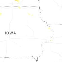
Iowa
| Local Time | Report Details |
|---|---|
| 10:45 PM CDT | A trained spotter reported 3 inch tree limbs down and a downed tree in spirit lake. time estimated via rada in dickinson county IA, 53.5 miles N of Storm Lake, IA |
| 11:12 PM CDT | Measured by public weather statio in hancock county IA, 30.3 miles WSW of Mason City, IA |
| 11:17 PM CDT | Measured by mason city aso in cerro gordo county IA, 6.5 miles W of Mason City, IA |
| 11:17 PM CDT | Measured by public weather statio in hancock county IA, 29.8 miles W of Mason City, IA |
| 11:19 PM CDT | Delayed report. trees and branches down across town. some trees on vehicles. several power poles reported to be on fire with power outages in the count in cerro gordo county IA, 0.5 miles WNW of Mason City, IA |
| 11:19 PM CDT | Report of a large tree split and blown down in britt. time estimated. delayed repor in hancock county IA, 30.5 miles W of Mason City, IA |
| 11:26 PM CDT | Large limbs down in plymouth and rock falls. tree on vehicle in rock fall in cerro gordo county IA, 6.8 miles NE of Mason City, IA |
| 11:26 PM CDT | Measured by public weather statio in worth county IA, 13.7 miles NE of Mason City, IA |
| 11:49 PM CDT | Emergency manager reported trees down in nora spring in floyd county IA, 10.2 miles E of Mason City, IA |
| 11:53 PM CDT | 911 call center reported multiple trees down in the city of osag in mitchell county IA, 22.1 miles ENE of Mason City, IA |
| 11:58 PM CDT | Emergency manager reported a tree down in the city of rockfor in floyd county IA, 14.3 miles ESE of Mason City, IA |
| 12:22 AM CDT | A personal weather station near sioux center recorded a 59 mph wind gust. time estimated via rada in sioux county IA, 44.4 miles SE of Sioux Falls, SD |
| 12:34 AM CDT | A personal weather station near rock rapids recorded a 62 mph wind gus in lyon county IA, 25.5 miles ESE of Sioux Falls, SD |
| 12:40 AM CDT | A personal weather station near orange city recorded a 60 mph wind gus in sioux county IA, 44.4 miles SE of Sioux Falls, SD |
| 12:55 AM CDT | A 58 mph wind gust was recorded at the sioux county regional airpor in sioux county IA, 48 miles SE of Sioux Falls, SD |
| 12:55 AM CDT | Storm damage reported in bremer county IA, 51 miles SE of Mason City, IA |
| 1:08 AM CDT | Storm damage reported in bremer county IA, 59.2 miles ESE of Mason City, IA |
| 1:14 AM CDT | Storm damage reported in black hawk county IA, 54.9 miles NW of Cedar Rapids, IA |
| 1:40 AM CDT | Woodbury county em reported 4 inch tree limbs down in hornick. time estimated via rada in woodbury county IA, 54.2 miles WSW of Storm Lake, IA |
| 1:43 AM CDT | A personal weather station northeast of ida grove recorded a 64 mph wind gus in ida county IA, 18.2 miles SSW of Storm Lake, IA |
| 2:30 AM CDT | An emergency manager relayed a report of a 70 mph wind gust at the woodbury county fairgrounds in moville... i in woodbury county IA, 45.6 miles WSW of Storm Lake, IA |
| 3:21 AM CDT | Roof blown off a hom in harrison county IA, 31.3 miles N of Omaha, NE |
Connect with Interactive Hail Maps