

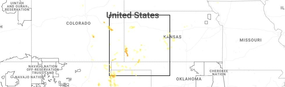
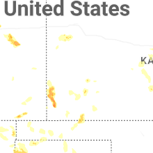
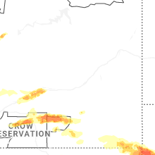
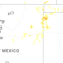
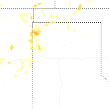
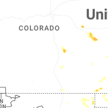
Hail Map for Saturday, July 5, 2025
Number of Impacted Households on 7/5/2025
0
Impacted by 1" or Larger Hail
0
Impacted by 1.75" or Larger Hail
0
Impacted by 2.5" or Larger Hail
Square Miles of Populated Area Impacted on 7/5/2025
0
Impacted by 1" or Larger Hail
0
Impacted by 1.75" or Larger Hail
0
Impacted by 2.5" or Larger Hail
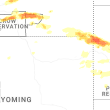
Cities Most Affected by Hail Storms of 7/5/2025
| Hail Size | Demographics of Zip Codes Affected | ||||||
|---|---|---|---|---|---|---|---|
| City | Count | Average | Largest | Pop Density | House Value | Income | Age |
| Manter, KS | 1 | 2.00 | 2.00 | 0 | $75k | $43.8k | 43.6 |
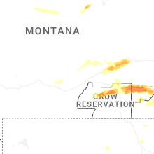
| Crow Agency, MT | 1 | 1.75 | 1.75 | 0 | $29k | $26.9k | 24.5 |
| Hardin, MT | 1 | 1.75 | 1.75 | 6 | $68k | $29.1k | 35.7 |
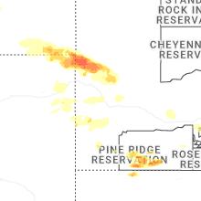
| Cora, WY | 1 | 1.75 | 1.75 | 0 | $134k | $36.3k | 52.0 |
Hail and Wind Damage Spotted on 7/5/2025
Filter by Report Type:Hail ReportsWind Reports
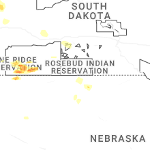
South Dakota
| Local Time | Report Details |
|---|---|
| 1:18 PM MDT | Half Dollar sized hail reported near Hot Springs, SD, 46.2 miles SSW of Rapid City, SD |
| 1:20 PM MDT | Quarter sized hail reported near Hot Springs, SD, 46.1 miles SSW of Rapid City, SD |
| 1:25 PM MDT | Quarter sized hail reported near Hot Springs, SD, 46.7 miles SSW of Rapid City, SD |
| 7:19 PM MDT | Storm damage reported in crook county WY, 77.1 miles NE of Gillette, WY |
| 7:30 PM MDT | Storm damage reported in butte county SD, 63.4 miles NW of Rapid City, SD |
| 7:35 PM MDT | Storm damage reported in butte county SD, 63.4 miles NW of Rapid City, SD |
| 7:40 PM MDT | Storm damage reported in butte county SD, 63.4 miles NW of Rapid City, SD |
| 7:50 PM MDT | Storm damage reported in butte county SD, 63.4 miles NW of Rapid City, SD |
| 7:50 PM MDT | Pea to dime sized hail in butte county SD, 58.4 miles NNW of Rapid City, SD |
| 7:55 PM MDT | Storm damage reported in lawrence county SD, 39.6 miles NW of Rapid City, SD |
| 7:56 PM MDT | Storm damage reported in butte county SD, 80.4 miles NNW of Rapid City, SD |
| 8:20 PM MDT | Storm damage reported in butte county SD, 44.4 miles NNW of Rapid City, SD |
| 8:30 PM MDT | Storm damage reported in butte county SD, 44.4 miles NNW of Rapid City, SD |
| 8:35 PM MDT | Storm damage reported in butte county SD, 44.4 miles NNW of Rapid City, SD |
| 8:50 PM MDT | Storm damage reported in meade county SD, 14 miles NE of Rapid City, SD |
| 8:55 PM MDT | Storm damage reported in butte county SD, 51 miles N of Rapid City, SD |
| 9:07 PM MDT | Storm damage reported in pennington county SD, 9.3 miles ESE of Rapid City, SD |
| 9:30 PM MDT | Storm damage reported in meade county SD, 45.8 miles NNE of Rapid City, SD |
| 9:40 PM MDT | Storm damage reported in pennington county SD, 36.4 miles E of Rapid City, SD |
| 9:45 PM MDT | Storm damage reported in pennington county SD, 38.9 miles E of Rapid City, SD |
| 9:50 PM MDT | Storm damage reported in pennington county SD, 36.4 miles E of Rapid City, SD |
| 10:26 PM MDT | Storm damage reported in jackson county SD, 61.3 miles E of Rapid City, SD |
| 10:30 PM MDT | Storm damage reported in jackson county SD, 69.3 miles E of Rapid City, SD |
| 10:40 PM MDT | Storm damage reported in jackson county SD, 72.3 miles ESE of Rapid City, SD |
| 11:12 PM MDT | Storm damage reported in jackson county SD, 67.5 miles WSW of Pierre, SD |
Wyoming
| Local Time | Report Details |
|---|---|
| 1:20 PM MDT | Golf Ball sized hail reported near Cora, WY, 82 miles W of Riverton, WY, trained spotter. |
| 6:19 PM MDT | Storm damage reported in crook county WY, 50.8 miles NNE of Gillette, WY |
| 6:35 PM MDT | Pea sized hail in crook county WY, 62.7 miles NE of Gillette, WY |
| 7:30 PM MDT | Storm damage reported in crook county WY, 61.5 miles NW of Rapid City, SD |
| 7:33 PM MDT | Storm damage reported in crook county WY, 61.5 miles NW of Rapid City, SD |
| 7:42 PM MDT | Storm damage reported in crook county WY, 52.7 miles NW of Rapid City, SD |
| 7:50 PM MDT | Photos show multiple large trees uprooted in crook county WY, 52.3 miles NW of Rapid City, SD |
| 7:54 PM MDT | Asos station krks rock springs airpor in sweetwater county WY, 8 miles E of Rock Springs, WY |
| 8:50 PM MDT | Mesonet station pc377 scenic d in natrona county WY, 4.2 miles SSE of Casper, WY |
| 8:52 PM MDT | Mesonet station wy47 casper 2.1 sw (wydot in natrona county WY, 2.9 miles SSE of Casper, WY |
Montana
| Local Time | Report Details |
|---|---|
| 1:34 PM MDT | Asos station kbil billing in yellowstone county MT, 2.4 miles WNW of Billings, MT |
| 2:46 PM MDT | Golf Ball sized hail reported near Hardin, MT, 43.1 miles ESE of Billings, MT, report from mping: golf ball (1.75 in.). |
| 3:15 PM MDT | Storm damage reported in treasure county MT, 63.2 miles ENE of Billings, MT |
| 3:30 PM MDT | Mesonet station mting 1.6 w ingomar (mt dot in rosebud county MT, 74.9 miles W of Miles City, MT |
| 3:35 PM MDT | Ping Pong Ball sized hail reported near Crow Agency, MT, 67.9 miles E of Billings, MT |
| 3:35 PM MDT | Golf Ball sized hail reported near Crow Agency, MT, 67.9 miles E of Billings, MT, corrects previous hail report from 11 nw busby. |
| 4:10 PM MDT | Storm damage reported in rosebud county MT, 68.4 miles SW of Miles City, MT |
| 4:27 PM MDT | Quarter sized hail reported near Lame Deer, MT, 67.5 miles SW of Miles City, MT |
| 4:54 PM MDT | Storm damage reported in rosebud county MT, 77.6 miles SSW of Miles City, MT |
| 5:05 PM MDT | Storm damage reported in powder river county MT, 70.1 miles NNW of Gillette, WY |
| 6:07 PM MDT | Multiple tree branches down... up to 3 inches in diamete in powder river county MT, 66.7 miles N of Gillette, WY |
| 6:15 PM MDT | Mesonet station mtden denton (mt dot in fergus county MT, 69.8 miles ESE of Great Falls, MT |
| 7:15 PM MDT | Storm damage reported in carter county MT, 74.2 miles NE of Gillette, WY |
| 7:41 PM MDT | Mesonet station armm8 armells creek raw in fergus county MT, 76.2 miles SSE of Havre, MT |
Iowa
| Local Time | Report Details |
|---|---|
| 4:09 PM CDT | Relayed report of a tree branch of unknown size was down one miles south of mosco in muscatine county IA, 41.6 miles SE of Cedar Rapids, IA |
| 4:53 PM CDT | Retired nws employee relayed photo on x of a large tree branch down in park view. time estimated by rada in scott county IA, 61.8 miles ESE of Cedar Rapids, IA |
| 7:35 PM CDT | 6 inch tree branch snapped off tree. 48 mph gus in polk county IA, 11 miles NW of Des Moines, IA |
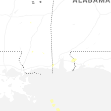
Alabama
| Local Time | Report Details |
|---|---|
| 4:49 PM CDT | Em reports powerlines down at grand bay wilmer road and warren creek road. time estimated via rada in mobile county AL, 21.8 miles SW of Mobile, AL |
| 4:54 PM CDT | Half Dollar sized hail reported near Grand Bay, AL, 24.1 miles SW of Mobile, AL, broadcast media shared photo of nearly half dollar sized hail. |
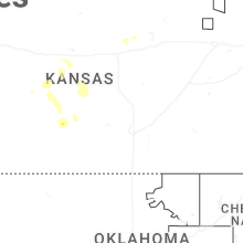
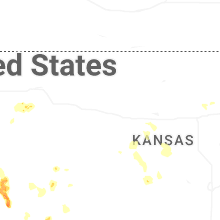
Kansas
| Local Time | Report Details |
|---|---|
| 6:00 PM CDT | Ping Pong Ball sized hail reported near Manter, KS, 63.3 miles WSW of Garden City, KS |
| 6:05 PM CDT | Hen Egg sized hail reported near Manter, KS, 63.3 miles WSW of Garden City, KS |
| 7:56 PM CDT | Awos station klbl libera in seward county KS, 65 miles S of Garden City, KS |
| 7:57 PM CDT | Mesonet station up352 2.7 sw liberal (upr in seward county KS, 66.4 miles S of Garden City, KS |
| 8:00 PM CDT | Quarter sized hail reported near Liberal, KS, 64.2 miles S of Garden City, KS, report made via social media. |
| 8:30 PM MDT | Cwop site gw613 in wallace county KS, 59.4 miles WSW of Colby, KS |
| 9:07 PM MDT | Spotter estimates 60 mph wind gusts and near zero visibility in rain on hwy 96 near ks/co borde in greeley county KS, 71.8 miles WNW of Garden City, KS |
| 9:13 PM MDT | Trained spotter estimates winds around 58 mph. supported by sending in a vide in greeley county KS, 59.4 miles NW of Garden City, KS |
| 9:23 PM MDT | Site c6099 reports 59 mph wind gus in wallace county KS, 55.1 miles SW of Colby, KS |
| 9:24 PM MDT | Site 5.5m e tribune ks reports 72 mph wind gus in greeley county KS, 54.6 miles NW of Garden City, KS |
| 9:31 PM MDT | Site dw9439 reports 62 mph wind gus in greeley county KS, 55.4 miles WNW of Garden City, KS |
| 10:53 PM CDT | Upr-mcla in logan county KS, 33.4 miles SW of Colby, KS |
| 11:09 PM CDT | Pws - kkslakin2 in kearny county KS, 31.3 miles WNW of Garden City, KS |
| 11:20 PM CDT | Pws - nwkecount in kearny county KS, 28.9 miles WNW of Garden City, KS |
Illinois
| Local Time | Report Details |
|---|---|
| 6:09 PM CDT | A section of a large tree was reported down in dakota... il. time is estimated from rada in stephenson county IL, 47.7 miles S of Madison, WI |
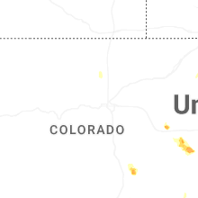
Colorado
| Local Time | Report Details |
|---|---|
| 5:58 PM MDT | Awos station kako akro in washington county CO, 26.6 miles W of Yuma, CO |
| 7:24 PM MDT | Site up729 reports wind gust of 62 mp in cheyenne county CO, 93.8 miles S of Yuma, CO |
| 7:46 PM MDT | Site kcocheye8 reports 62 mph wind gus in cheyenne county CO, 90.8 miles WSW of Colby, KS |
| 7:52 PM MDT | Site co068 reports 61 mph wind gus in cheyenne county CO, 89.7 miles WSW of Colby, KS |
| 7:55 PM MDT | Site kitr reports 63 mph wind gus in kit carson county CO, 64.4 miles SSE of Yuma, CO |
| 8:27 PM MDT | Site up694 reports wind gust to 62 mp in cheyenne county CO, 69.4 miles WSW of Colby, KS |
Texas
| Local Time | Report Details |
|---|---|
| 7:50 PM CDT | Severe wind gusts occurred at the dalhart 12sw mesonet site from a likely anvil gust from a nearby thunderstorm. the mesonet site initially gusted to 61mph at 0749pm. in hartley county TX, 69.1 miles NW of Amarillo, TX |
| 8:31 PM CDT | Mesonet station 118 romero 11ssw. severe gusts started at 817 pm and continue through 837 with peak occurring at 8:31 p in oldham county TX, 50.9 miles ENE of Tucumcari, NM |
| 9:03 PM CDT | Mesonet station 109 adrian 6ws in oldham county TX, 52.5 miles W of Amarillo, TX |
| 10:50 PM CDT | Measured by the ttu mesone in parmer county TX, 61.9 miles SW of Amarillo, TX |
Connect with Interactive Hail Maps