

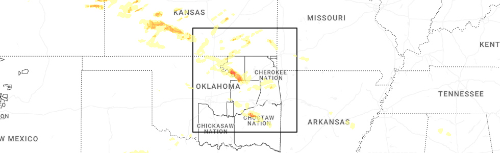
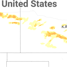
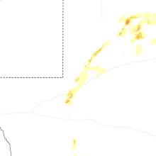
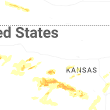
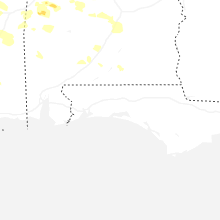
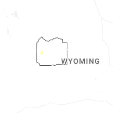
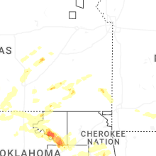
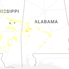
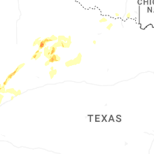
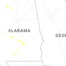
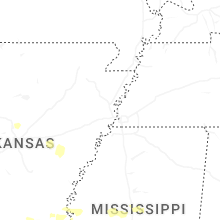
Hail Map for Saturday, May 24, 2025
Number of Impacted Households on 5/24/2025
0
Impacted by 1" or Larger Hail
0
Impacted by 1.75" or Larger Hail
0
Impacted by 2.5" or Larger Hail
Square Miles of Populated Area Impacted on 5/24/2025
0
Impacted by 1" or Larger Hail
0
Impacted by 1.75" or Larger Hail
0
Impacted by 2.5" or Larger Hail

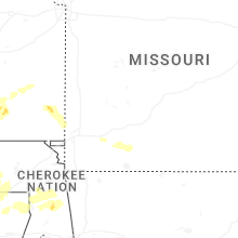
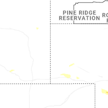


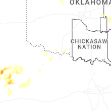
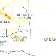
Cities Most Affected by Hail Storms of 5/24/2025
| Hail Size | Demographics of Zip Codes Affected | ||||||
|---|---|---|---|---|---|---|---|
| City | Count | Average | Largest | Pop Density | House Value | Income | Age |
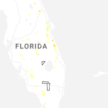
| Vero Beach, FL | 2 | 1.75 | 1.75 | 526 | $94k | $36.9k | 41.6 |
| Kiowa, CO | 1 | 2.00 | 2.00 | 7 | $183k | $49.4k | 44.2 |
| Mcalester, OK | 1 | 1.75 | 1.75 | 50 | $58k | $30.5k | 39.9 |
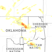
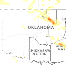
Hail and Wind Damage Spotted on 5/24/2025
Filter by Report Type:Hail ReportsWind Reports
States Impacted
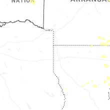
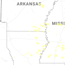
Oklahoma, Arkansas, Florida, Mississippi, Louisiana, Colorado, Nebraska, Alabama, Texas, KansasOklahoma
| Local Time | Report Details |
|---|---|
| 7:47 AM CDT | Large tree limb downe in hughes county OK, 35.5 miles N of Atoka, OK |
| 7:54 AM CDT | 3se stuart mesonet repor in pittsburg county OK, 35.5 miles N of Atoka, OK |
| 7:57 AM CDT | Storm damage reported in pittsburg county OK, 40 miles NNE of Atoka, OK |
| 8:00 AM CDT | Golf Ball sized hail reported near Mcalester, OK, 42.7 miles NNE of Atoka, OK |
| 8:00 AM CDT | Damage to metal roof. pictures shared via social medi in pittsburg county OK, 42.7 miles NNE of Atoka, OK |
| 8:00 AM CDT | Few powerlines dow in pittsburg county OK, 42.7 miles NNE of Atoka, OK |
| 8:05 AM CDT | Half Dollar sized hail reported near Krebs, OK, 44.1 miles NNE of Atoka, OK, report from mping: half dollar (1.25 in.). |
| 9:29 AM CDT | Bethel fire department reports trees down along us 259 near the triangl in mccurtain county OK, 62.3 miles WNW of Nashville, AR |
| 9:00 PM CDT | Quarter sized hail reported near Arnett, OK, 44.8 miles SW of Woodward, OK |
| 12:25 AM CDT | Quarter sized hail reported near Grandfield, OK, 24.4 miles NNW of Wichita Falls, TX |
| 12:29 AM CDT | Quarter sized hail reported near Tonkawa, OK, 68.8 miles S of Wichita, KS, report from mping: quarter (1.00 in.). |
| 1:40 AM CDT | Awos station kfsi fort sill. wake lo in comanche county OK, 51.4 miles N of Wichita Falls, TX |
| 2:25 AM CDT | Mesonet station altu altus. wake lo in jackson county OK, 50.9 miles ENE of Childress, TX |
| 2:30 AM CDT | Walters mesonet. wake lo in cotton county OK, 35 miles NNE of Wichita Falls, TX |
| 2:35 AM CDT | Mesonet station altu altus. wake lo in jackson county OK, 50.9 miles ENE of Childress, TX |
| 2:45 AM CDT | Mesonet station medi medicine park. wake lo in comanche county OK, 56.8 miles N of Wichita Falls, TX |
| 2:50 AM CDT | Mesonet station altu altus. wake lo in jackson county OK, 50.9 miles ENE of Childress, TX |
| 2:50 AM CDT | Mesonet station medi medicine park. wake lo in comanche county OK, 56.8 miles N of Wichita Falls, TX |
| 2:50 AM CDT | Quarter sized hail reported near Sand Springs, OK, 14.4 miles W of Tulsa, OK |
| 2:52 AM CDT | Ping Pong Ball sized hail reported near Sand Springs, OK, 13.4 miles W of Tulsa, OK, report from mping: ping pong ball (1.50 in.). |
| 2:55 AM CDT | Awos station klts altus afb. wake lo in jackson county OK, 56.2 miles ENE of Childress, TX |
| 3:00 AM CDT | Quarter sized hail reported near Tulsa, OK, 4.3 miles W of Tulsa, OK, 49th west avenue and highway 412. |
| 3:01 AM CDT | Quarter sized hail reported near Sand Springs, OK, 14.4 miles W of Tulsa, OK |
| 3:05 AM CDT | Awos station klts altus afb. wake lo in jackson county OK, 56.2 miles ENE of Childress, TX |
| 3:10 AM CDT | Mesonet station tipt tipton. wake lo in tillman county OK, 51.8 miles NW of Wichita Falls, TX |
| 3:25 AM CDT | Quarter sized hail reported near Tulsa, OK, 6.5 miles ESE of Tulsa, OK |
| 3:27 AM CDT | Quarter sized hail reported near Tulsa, OK, 5.9 miles ESE of Tulsa, OK, at koki fox23 studios. |
| 3:45 AM CDT | Mesonet station acme acme. wake lo in grady county OK, 53.4 miles SSW of Oklahoma City, OK |
| 3:50 AM CDT | Mesonet station acme acme. wake lo in grady county OK, 53.4 miles SSW of Oklahoma City, OK |
| 4:20 AM CDT | Mesonet station ftcb fort cobb. wake lo in caddo county OK, 58.1 miles WSW of Oklahoma City, OK |
| 4:35 AM CDT | Awos station kchk chickasha. wake lo in grady county OK, 36.1 miles SW of Oklahoma City, OK |
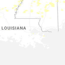
Arkansas
| Local Time | Report Details |
|---|---|
| 1:49 PM CDT | Trees and a powerline down in crosset in ashley county AR, 25.1 miles N of Bastrop, LA |
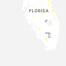
Florida
| Local Time | Report Details |
|---|---|
| 3:01 PM EDT | Quarter sized hail reported near Palm Bay, FL, 52.5 miles NNW of Port Saint Lucie, FL, trained spotter reports nickel to quarter-size hail in palm bay. |
| 3:01 PM EDT | Half Dollar sized hail reported near Palm Bay, FL, 52.5 miles NNW of Port Saint Lucie, FL, updates previous hail report from palm bay. trained spotter reports nickel to half-dollar-size hail in palm bay. hail lasted 2 to 4 mintues. |
| 3:05 PM EDT | Quarter sized hail reported near Palm Bay, FL, 52.3 miles NNW of Port Saint Lucie, FL, quarter size hail near grandeur st and emerson dr se in palm bay. |
| 3:10 PM EDT | Golf Ball sized hail reported near Vero Beach, FL, 34.3 miles NNW of Port Saint Lucie, FL, delayed report. a member of the public reports golf ball size (1 3/4 inch) hail at vero lake estates. |
| 3:12 PM EDT | Reports of large tree branch falling on roof of a home on grandeur st in palm bay. time est by rada in brevard county FL, 52.3 miles NNW of Port Saint Lucie, FL |
| 3:15 PM EDT | Quarter sized hail reported near Palm Bay, FL, 52.5 miles NNW of Port Saint Lucie, FL, trained spotter reports quarter-size hail covering ground on windbrook in palm bay. |
| 3:32 PM EDT | Quarter sized hail reported near Vero Beach, FL, 35 miles NNW of Port Saint Lucie, FL, trained spotter estimates hail to quarter size at minds eye observatory (private) in vero lake estates. |
| 3:32 PM EDT | Golf Ball sized hail reported near Vero Beach, FL, 34.3 miles NNW of Port Saint Lucie, FL, estimated quarter to golf ball size hail based on photos shared by local media in vero lake estates. |
| 3:35 PM EDT | Trained spotter near cogan/san filipo in palm bay estimates 60 mph winds and broken pine tree branches. also... reports pea to quarter-size hai in brevard county FL, 52.5 miles NNW of Port Saint Lucie, FL |
| 3:40 PM EDT | Quarter sized hail reported near Vero Beach, FL, 34.3 miles NNW of Port Saint Lucie, FL, quarter size hail estimated in vero lake estates by trained spotter. |
| 3:46 PM EDT | Half Dollar sized hail reported near Vero Beach, FL, 34.3 miles NNW of Port Saint Lucie, FL, delayed report. a member of the public reports half dollar size (1 /1/2) hail at vero lake estates. |
| 3:50 PM EDT | Quarter sized hail reported near Lehigh Acres, FL, 37.9 miles NNE of Naples, FL, broadcast media relayed viewer-submitted video of hail falling at a residence on 15th street near joel blvd... estimated up to around 1 inch in diameter. |
| 3:52 PM EDT | Quarter sized hail reported near Cocoa, FL, 35.6 miles ESE of Orlando, FL, [delayed] report and subsequent photo indicates quarter size hail fell near adamson creek in cocoa. |
| 4:32 PM EDT | Quarter sized hail reported near Deland, FL, 40.9 miles NNE of Orlando, FL, image submitted via social media of several hailstones... one of which measuring near 1 inch in diameter. |
| 4:43 PM EDT | Video submitted to local media shows extensive damage to a fence and shed along carlton rd (cr-613) - time est. from microburst signature on rada in st. lucie county FL, 10.3 miles W of Port Saint Lucie, FL |
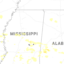
Mississippi
| Local Time | Report Details |
|---|---|
| 2:35 PM CDT | Tree limbs downed on augusta stree in sunflower county MS, 83.9 miles NNW of Jackson, MS |
| 2:37 PM CDT | A couple of trees and powerline downed along highway in washington county MS, 55.7 miles ENE of Bastrop, LA |
| 3:05 PM CDT | A tree fell on a house and another tree fell on a powerline and caught on fire. several other trees were also downed across the count in sharkey county MS, 60 miles NW of Jackson, MS |
| 3:05 PM CDT | Several trees down along with a roof blown off of a buildin in humphreys county MS, 64 miles NNW of Jackson, MS |
| 3:28 PM CDT | Few trees downed in tchul in holmes county MS, 61.5 miles N of Jackson, MS |
| 3:32 PM CDT | Quarter sized hail reported near Noxapater, MS, 35.8 miles SSW of Starkville, MS |
| 3:37 PM CDT | Several trees downed across the count in sharkey county MS, 47.8 miles NW of Jackson, MS |
| 3:42 PM CDT | Quarter sized hail reported near Pearl, MS, 6.1 miles ENE of Jackson, MS, one inch hail observed at the wfo jackson... ms office. |
| 3:52 PM CDT | Quarter sized hail reported near Pearl, MS, 6.8 miles ENE of Jackson, MS |
| 4:00 PM CDT | Few trees downed in duran in holmes county MS, 57 miles NNE of Jackson, MS |
| 4:25 PM CDT | Numerous trees and powerlines reported down across the count in neshoba county MS, 50.5 miles SSW of Starkville, MS |
| 4:27 PM CDT | Corrects previous tstm wnd dmg report from 5 sse beechwood. trees and powerline down off of sweetgum lan in warren county MS, 36.3 miles W of Jackson, MS |
| 4:33 PM CDT | Multiple branches of a large tree were split along mccool stevenson r in choctaw county MS, 34.3 miles SW of Starkville, MS |
| 4:38 PM CDT | Tree downed across ms hwy 1 in attala county MS, 40.6 miles SW of Starkville, MS |
| 4:50 PM CDT | Tree downed at s union rd and lebanon r in choctaw county MS, 25.9 miles WSW of Starkville, MS |
| 5:00 PM CDT | Several trees downed across the count in winston county MS, 27.8 miles SSW of Starkville, MS |
| 5:00 PM CDT | Several trees downed across portions of the count in copiah county MS, 34.7 miles SSW of Jackson, MS |
| 5:05 PM CDT | Few trees downed in polkvill in smith county MS, 29.5 miles ESE of Jackson, MS |
| 5:46 PM CDT | 62.6 mph wind gust measured along athens roa in simpson county MS, 34.7 miles SE of Jackson, MS |
| 5:52 PM CDT | Trees downed near fayett in jefferson county MS, 65.2 miles SW of Jackson, MS |
| 5:58 PM CDT | A few trees downed around meridia in lauderdale county MS, 75.8 miles S of Starkville, MS |
| 5:59 PM CDT | Powerlines downed on meadville gloster r in franklin county MS, 71.8 miles SW of Jackson, MS |
| 6:15 PM CDT | Few trees downed around taylorsvill in smith county MS, 54.6 miles SE of Jackson, MS |
| 6:17 PM CDT | Few trees downed near taylorsvill in smith county MS, 55.5 miles SE of Jackson, MS |
| 6:37 PM CDT | Several trees downed along ms hwy 583 south of brookhave in lincoln county MS, 58.3 miles SSW of Jackson, MS |
| 6:42 PM CDT | Quarter sized hail reported near Bogue Chitto, MS, 58.4 miles SSW of Jackson, MS, reported on ms hwy 583. |
| 6:50 PM CDT | Tree reported across a road in libert in amite county MS, 86.8 miles SSW of Jackson, MS |
| 7:10 PM CDT | Tree in roadway on west hills d in lamar county MS, 81.8 miles SE of Jackson, MS |
| 7:50 PM CDT | Tree in roadway near the intersection of caney church rd and purvis to columbia r in lamar county MS, 84.7 miles SSE of Jackson, MS |
Louisiana
| Local Time | Report Details |
|---|---|
| 2:37 PM CDT | Couple of trees reported down in mer roug in morehouse county LA, 7.3 miles E of Bastrop, LA |
| 3:00 PM CDT | Few trees downed across the paris in east carroll county LA, 38.7 miles E of Bastrop, LA |
| 4:54 PM CDT | Tree downed in sicily islan in catahoula county LA, 64.3 miles SSE of Bastrop, LA |
| 5:09 PM CDT | Few trees and powerlines downed near clayto in concordia county LA, 75.5 miles SSE of Bastrop, LA |
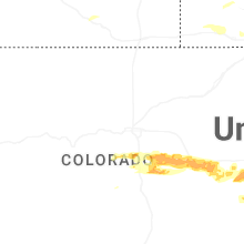
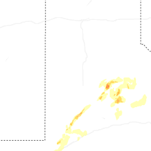
Colorado
| Local Time | Report Details |
|---|---|
| 2:24 PM MDT | Half Dollar sized hail reported near Elizabeth, CO, 34.9 miles SE of Denver, CO, report from mping: half dollar (1.25 in.). |
| 2:41 PM MDT | Hen Egg sized hail reported near Kiowa, CO, 40.4 miles SE of Denver, CO, report from mping: hen egg (2.00 in.). |
| 3:50 PM MDT | Quarter sized hail reported near Elizabeth, CO, 39.5 miles SE of Denver, CO, report from mping: quarter (1.00 in.). |
| 4:07 PM MDT | Quarter sized hail reported near Larkspur, CO, 42.7 miles S of Denver, CO |
| 4:08 PM MDT | Half Dollar sized hail reported near Monument, CO, 43 miles S of Denver, CO |
| 4:15 PM MDT | Half Dollar sized hail reported near Elbert, CO, 44.5 miles SE of Denver, CO, report from mping: half dollar (1.25 in.). |
| 5:20 PM MDT | Quarter sized hail reported near Peyton, CO, 51.4 miles SSE of Denver, CO |
| 5:25 PM MDT | Half Dollar sized hail reported near Peyton, CO, 55.4 miles SSE of Denver, CO |
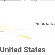
Nebraska
| Local Time | Report Details |
|---|---|
| 4:45 PM MDT | Storm damage reported in scotts bluff county NE, 0.6 miles NNE of Scottsbluff, NE |
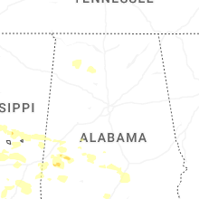
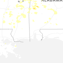
Alabama
| Local Time | Report Details |
|---|---|
| 6:27 PM CDT | Quarter sized hail reported near Gallion, AL, 45.3 miles NW of Camden, AL, social media photo of at least quarter size hail. |
| 7:58 PM CDT | Trees down near peach tree rd and danzy settlement rd. time estimated by rada in clarke county AL, 25.6 miles WSW of Camden, AL |
| 8:22 PM CDT | Trees blocking both lanes of wiggins rd. time estimated by rada in clarke county AL, 47.2 miles SW of Camden, AL |
| 8:29 PM CDT | Trees down on forest rd. time estimated by rada in clarke county AL, 48.5 miles SW of Camden, AL |
| 8:29 PM CDT | Trees down on gainestown rd. time estimated by rada in clarke county AL, 48.2 miles SW of Camden, AL |
| 8:35 PM CDT | Large tree blocking both lanes at intersection of allen walker rd and walker springs rd. time estimated by rada in clarke county AL, 42.8 miles SW of Camden, AL |
Texas
| Local Time | Report Details |
|---|---|
| 8:05 PM CDT | Measured by ttu mesone in dickens county TX, 56.9 miles E of Lubbock, TX |
| 8:48 PM CDT | Measured by ttu mesone in king county TX, 61.2 miles SSW of Childress, TX |
| 8:59 PM CDT | Also gusted to 59 mph at 852 pm and 858 pm. measured by ttu mesone in king county TX, 61.2 miles SSW of Childress, TX |
| 9:19 PM CDT | Measured by ttu mesone in garza county TX, 40.3 miles SSE of Lubbock, TX |
| 10:02 PM CDT | Measured by ttu mesone in stonewall county TX, 56.4 miles NNW of Abilene, TX |
| 12:14 AM CDT | Storm damage reported in foard county TX, 33.5 miles SSE of Childress, TX |
| 1:45 AM CDT | Mesonet station 62 wilbarger county texas. wake lo in wilbarger county TX, 49.4 miles E of Childress, TX |
| 2:04 AM CDT | Mesonet station 62 wilbarger county texas. wake lo in wilbarger county TX, 49.4 miles E of Childress, TX |
| 2:30 AM CDT | Mesonet station 59 3nw knox city. wake lo in knox county TX, 69.3 miles N of Abilene, TX |
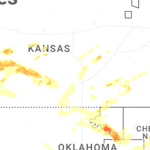
Kansas
| Local Time | Report Details |
|---|---|
| 12:09 AM CDT | Quarter sized hail reported near Anthony, KS, 53.2 miles SW of Wichita, KS |
| 2:28 AM CDT | Quarter sized hail reported near Whitewater, KS, 19.4 miles NNE of Wichita, KS |
| 3:14 AM CDT | Quarter sized hail reported near Girard, KS, 26.7 miles ESE of Chanute, KS |
| 4:45 AM CDT | Kansas state mesonet site hodgeman count in hodgeman county KS, 53.8 miles E of Garden City, KS |
| 5:16 AM CDT | B-hart-far in hodgeman county KS, 61.8 miles SSW of Hays, KS |
| 5:26 AM CDT | B-hart-far in hodgeman county KS, 62.3 miles SSW of Hays, KS |
| 6:05 AM CDT | 67 mph wind gust from a personal weather statio in barton county KS, 46.6 miles SSE of Hays, KS |
| 6:15 AM CDT | Ambient weather network site: pratt county landfil in pratt county KS, 76.6 miles W of Wichita, KS |
Connect with Interactive Hail Maps