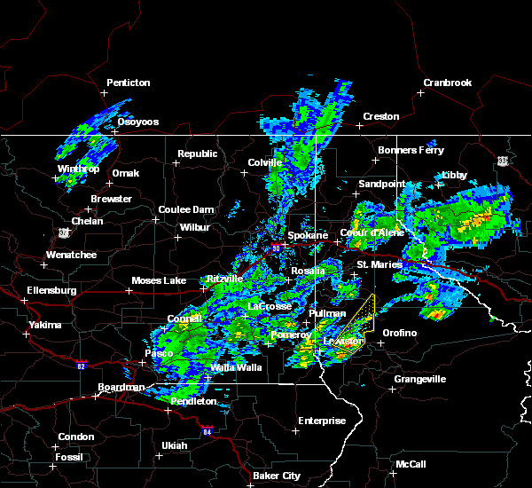
| 8/17/2020 6:25 PM PDT |
 At 622 pm pdt, a severe thunderstorm was located 19 miles northeast of enterprise, moving northeast at 35 mph. the thunderstorms are looking to enter nez perce county by 6:45pm. brief heavy downpours and wind gusts up to 50 mph are possible (doppler radar indicated). Hazards include 50 mph wind gusts and penny size hail. expect damage to roofs, siding, and trees At 622 pm pdt, a severe thunderstorm was located 19 miles northeast of enterprise, moving northeast at 35 mph. the thunderstorms are looking to enter nez perce county by 6:45pm. brief heavy downpours and wind gusts up to 50 mph are possible (doppler radar indicated). Hazards include 50 mph wind gusts and penny size hail. expect damage to roofs, siding, and trees
|
| 6/8/2016 4:48 PM PDT |
 At 447 pm pdt, doppler radar indicated a severe thunderstorm capable of producing quarter size hail. this storm was located near juliaetta, or 11 miles northeast of lapwai, and moving northeast at 40 mph. * this severe thunderstorm will be near, bovill around 515 pm pdt. other locations impacted by this severe thunderstorm include lenore, gifford, helmer and southwick. At 447 pm pdt, doppler radar indicated a severe thunderstorm capable of producing quarter size hail. this storm was located near juliaetta, or 11 miles northeast of lapwai, and moving northeast at 40 mph. * this severe thunderstorm will be near, bovill around 515 pm pdt. other locations impacted by this severe thunderstorm include lenore, gifford, helmer and southwick.
|
| 6/1/2015 6:40 PM PDT |
Trees blown down on us 12 at mile marker 21 in latah county ID, 1.3 miles E of Kendrick, ID
|
| 6/1/2015 6:36 PM PDT |
At 633 pm pdt, doppler radar indicated a severe thunderstorm capable of producing hail between nickels and quarters and damaging winds to 60 mph. this storm has a history of producing extremely heavy rainfall with spotters reporting just under an inch of rain in under 30 minutes. this storm was located between lenore and juliaetta, moving northeast at 45 mph. locations impacted include, genesee, troy, juliaetta, deary, kendrick, bovill, lenore, southwick, harvard, joel and helmer.
|
| 6/1/2015 6:12 PM PDT |
At 611 pm pdt, doppler radar indicated a line of severe thunderstorms capable of producing quarter to half dollar size hail and damaging winds to 60 mph. this storm was located near culdesac, or near lapwai, and moving northeast at 45 mph. there are multiple cells in this line capable of producing large hail.
|
| 7/20/2012 1:40 PM PDT |
Quarter sized hail reported 2.6 miles S of Kendrick, ID
|
| 7/20/2012 1:15 PM PDT |
Quarter sized hail reported 0.3 miles NW of Kendrick, ID, public reported hail.
|
 At 622 pm pdt, a severe thunderstorm was located 19 miles northeast of enterprise, moving northeast at 35 mph. the thunderstorms are looking to enter nez perce county by 6:45pm. brief heavy downpours and wind gusts up to 50 mph are possible (doppler radar indicated). Hazards include 50 mph wind gusts and penny size hail. expect damage to roofs, siding, and trees
 At 447 pm pdt, doppler radar indicated a severe thunderstorm capable of producing quarter size hail. this storm was located near juliaetta, or 11 miles northeast of lapwai, and moving northeast at 40 mph. * this severe thunderstorm will be near, bovill around 515 pm pdt. other locations impacted by this severe thunderstorm include lenore, gifford, helmer and southwick.


Connect with Interactive Hail Maps