

Hail Map for Monday, August 1, 2022

Number of Impacted Households on 8/1/2022
0
Impacted by 1" or Larger Hail
0
Impacted by 1.75" or Larger Hail
0
Impacted by 2.5" or Larger Hail
Square Miles of Populated Area Impacted on 8/1/2022
0
Impacted by 1" or Larger Hail
0
Impacted by 1.75" or Larger Hail
0
Impacted by 2.5" or Larger Hail


Cities Most Affected by Hail Storms of 8/1/2022
| Hail Size | Demographics of Zip Codes Affected | ||||||
|---|---|---|---|---|---|---|---|
| City | Count | Average | Largest | Pop Density | House Value | Income | Age |
| Olney, IL | 2 | 1.88 | 2.00 | 79 | $65k | $31.0k | 42.3 |
| Newton, IL | 1 | 1.75 | 1.75 | 29 | $68k | $33.8k | 42.5 |
Hail and Wind Damage Spotted on 8/1/2022
Filter by Report Type:Hail ReportsWind Reports
States Impacted
Indiana, Michigan, Louisiana, Virginia, North Carolina, Alabama, Illinois, South Carolina, Pennsylvania, West Virginia, Kentucky, Nebraska, Nevada, New Mexico, South Dakota, UtahIndiana
| Local Time | Report Details |
|---|---|
| 8:03 AM EDT | Trees reported down between rosedale road and gallagher road in northern vigo county. time estimated via rada in vigo county IN, 58.5 miles E of Mattoon, IL |
| 8:17 AM EDT | 1600 without power due to thunderstorm wind damage. time estimated via rada in putnam county IN, 35.1 miles W of Indianapolis, IN |
| 8:35 AM EDT | Up to 900 without power due to thunderstorm wind damage. time estimated via rada in boone county IN, 25.9 miles NW of Indianapolis, IN |
| 8:35 AM EDT | Numerous trees down on camp street near the elementary school. powerlines affected by tree damage. time estimated via rada in boone county IN, 26.8 miles NW of Indianapolis, IN |
| 8:52 AM EDT | Five homes damaged in heatherwood estates subdivision. multiple trees down... some through the roofs of homes. no injuries reported. time estimated via rada in marion county IN, 7 miles W of Indianapolis, IN |
| 8:54 AM EDT | Law enforcement reports a downed tree is completely blocking us421 at valley meadow drive. power is out in zionsvill in boone county IN, 15 miles NNW of Indianapolis, IN |
| 9:00 AM EDT | Em reports that a tree is down on a house in carmel; local fire and rescue respondin in hamilton county IN, 12 miles N of Indianapolis, IN |
| 9:00 AM EDT | Trees reported down at the intersection of raymond street and sherman drive. time estimated via rada in marion county IN, 3.2 miles SE of Indianapolis, IN |
| 9:03 AM EDT | Large tree down at bear slide golf club in cicero. time estimated via rada in hamilton county IN, 24.9 miles NNE of Indianapolis, IN |
| 9:05 AM EDT | Em reports multiple trees down into power line in hamilton county IN, 15.4 miles N of Indianapolis, IN |
| 9:09 AM EDT | Large tree limbs down at intersection of southport and combs. time estimated via rada in marion county IN, 9.7 miles SSE of Indianapolis, IN |
| 9:13 AM EDT | Retired nws employee reports 70mph estimated wind gust in fisher in hamilton county IN, 17.1 miles NNE of Indianapolis, IN |
| 9:17 AM EDT | Trained spotter reports 60 mph estimated wind gust at london road and i-7 in shelby county IN, 15.9 miles ESE of Indianapolis, IN |
| 9:27 AM EDT | Em reports trees down in the area of 200n and alexandria pike. some trees down on houses. time estimated via rada in madison county IN, 36.6 miles NE of Indianapolis, IN |
| 6:54 PM CDT | Tree down and took down power line in vanderburgh county IN, 10 miles N of Evansville, IN |
| 6:55 PM CDT | Storm damage reported in vanderburgh county IN, 5.8 miles N of Evansville, IN |
| 6:58 PM CDT | Evansville airport aso in vanderburgh county IN, 4.7 miles NNE of Evansville, IN |
| 6:59 PM CDT | Mping report: 1-inch tree limbs broken; shingles blown of in vanderburgh county IN, 3.9 miles NNW of Evansville, IN |
| 7:02 PM CDT | Kevv aso in vanderburgh county IN, 4.7 miles NNE of Evansville, IN |
| 7:03 PM CDT | Large tree down and across st george road... taking out a power lin in vanderburgh county IN, 4.7 miles NE of Evansville, IN |
| 7:04 PM CDT | Tree down across road on n boeke r in vanderburgh county IN, 2.6 miles ENE of Evansville, IN |
| 7:05 PM CDT | Tree across heidelbach av in vanderburgh county IN, 0.3 miles NE of Evansville, IN |
| 7:08 PM CDT | Mping report; 3-inch tree limbs broken; power poles broke in vanderburgh county IN, 3.7 miles NE of Evansville, IN |
| 7:08 PM CDT | Trees down near wesselman park; roof damage to nearby buildin in vanderburgh county IN, 2.4 miles E of Evansville, IN |
| 7:15 PM CDT | Numerous tree limbs dow in vanderburgh county IN, 1.4 miles ESE of Evansville, IN |
Michigan
| Local Time | Report Details |
|---|---|
| 1:45 PM EDT | Report of multiple trees down on intersection of saginaw rd and sheridan rd in tuscola county MI, 25.6 miles NNE of Flint, MI |
| 1:56 PM EDT | Report of multiple trees down near intersection of caine rd and waterman r in tuscola county MI, 27.5 miles NNE of Flint, MI |
| 2:02 PM EDT | Report of multiple trees down near intersection of sheridan rd and waterman rd. possible tornad in tuscola county MI, 28.2 miles NNE of Flint, MI |
| 2:14 PM EDT | Report of multiple trees down near intersection of m24 and state rte 46. possible tornad in tuscola county MI, 31.6 miles NNE of Flint, MI |
Louisiana
| Local Time | Report Details |
|---|---|
| 3:15 PM CDT | Central fire department shared a photo of a tree down on frenchtown rd between country and planchet rd on social medi in east baton rouge county LA, 63.2 miles ENE of Lafayette, LA |
| 3:39 PM CDT | Trees reported down on interstate 12 at louisiana highway 44 in tangipahoa county LA, 39.3 miles NNW of New Orleans, LA |
Virginia
| Local Time | Report Details |
|---|---|
| 4:30 PM EDT | One tree fell on a car and multiple areas with downed power lines across the southern peninsula. time estimated from rada in city of hampton county VA, 24.2 miles NW of Virginia Beach, VA |
| 10:37 PM EDT | Tree reported down on the 300 block of belmont driv in loudoun county VA, 53 miles WSW of Baltimore, MD |
| 10:50 PM EDT | Large tree branch reported down on riverpoint drive near lansdowne golf cours in loudoun county VA, 49.1 miles WSW of Baltimore, MD |
North Carolina
| Local Time | Report Details |
|---|---|
| 4:31 PM EDT | Pitt county 911 center reports a tree down across sunnyside rd near the intersection of old pactolus rd. time estimated from rada in pitt county NC, 76.4 miles E of Raleigh, NC |
| 4:45 PM EDT | Duplin co em reports tree down on building. time estimated by rada in duplin county NC, 50 miles N of Wilmington, NC |
| 4:46 PM EDT | Multiple downed trees reported near bradford creek public golf cours in pitt county NC, 77.5 miles E of Raleigh, NC |
| 5:18 PM EDT | Tree down near lakeview ave and catherine lake r in onslow county NC, 45.9 miles NNE of Wilmington, NC |
| 5:18 PM EDT | Tree reported down on garage and vehicle on gregory fork rd. time estimated by rada in onslow county NC, 49.7 miles NNE of Wilmington, NC |
Alabama
| Local Time | Report Details |
|---|---|
| 3:38 PM CDT | Trees down (mping report in montgomery county AL, 48.3 miles WSW of Auburn, AL |
| 3:38 PM CDT | Large pine tree uprooted on hill hedge driv in montgomery county AL, 49.3 miles WSW of Auburn, AL |
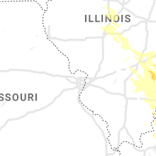
Illinois
| Local Time | Report Details |
|---|---|
| 3:45 PM CDT | Half Dollar sized hail reported near Dieterich, IL, 29.1 miles S of Mattoon, IL, report relayed from broadcast media. |
| 4:10 PM CDT | Quarter sized hail reported near Wheeler, IL, 29.9 miles S of Mattoon, IL, mix of pea to quarter size hail. |
| 4:31 PM CDT | Ping Pong Ball sized hail reported near Newton, IL, 41.8 miles SSE of Mattoon, IL |
| 4:35 PM CDT | Quarter sized hail reported near Newton, IL, 37.7 miles S of Mattoon, IL, quarter size hail report near newton power station. time estimated by radar. |
| 4:40 PM CDT | Half Dollar sized hail reported near Dundas, IL, 47.5 miles SSE of Mattoon, IL, via social media. |
| 4:40 PM CDT | Golf Ball sized hail reported near Newton, IL, 39.4 miles S of Mattoon, IL |
| 4:55 PM CDT | Large tree blown down on n east st... a few yds from carle richland memorial hospital. via social medi in richland county IL, 53.6 miles SSE of Mattoon, IL |
| 4:55 PM CDT | Quarter sized hail reported near Olney, IL, 54.9 miles SSE of Mattoon, IL |
| 4:58 PM CDT | Hen Egg sized hail reported near Olney, IL, 54.2 miles SSE of Mattoon, IL, via social media. |
| 5:00 PM CDT | Golf Ball sized hail reported near Olney, IL, 54.4 miles SSE of Mattoon, IL, range of sizes averaging 1.25 inch and as large as golf ball size. |
| 5:56 PM CDT | Ping Pong Ball sized hail reported near Mount Carmel, IL, 32.4 miles NNW of Evansville, IN, reported on highway 15 just east of bellmont. |
| 6:03 PM CDT | Quarter sized hail reported near , , 30.4 miles NNW of Evansville, IN |
| 6:10 PM CDT | Quarter sized hail reported near Sumner, IL, 53.1 miles NNW of Evansville, IN, reported via social media. |
| 6:50 PM CDT | Three foot diameter trees snapped and uproote in lawrence county IL, 47.8 miles NNW of Evansville, IN |
| 8:30 PM CDT | Quarter sized hail reported near Olney, IL, 54 miles NNW of Evansville, IN |
| 8:40 PM CDT | Half Dollar sized hail reported near Albion, IL, 39.4 miles NW of Evansville, IN |
| 3:39 AM CDT | Quarter sized hail reported near Dawson, IL, 58.5 miles S of Peoria, IL, report from mping: quarter (1.00 in.). |
South Carolina
| Local Time | Report Details |
|---|---|
| 5:47 PM EDT | Tree down across twin bridge rd near the intersection with cale yarborough hwy in florence county SC, 58.9 miles N of Charleston, SC |
Pennsylvania
| Local Time | Report Details |
|---|---|
| 6:04 PM EDT | Wires down in claysvill in washington county PA, 30.9 miles SW of Pittsburgh, PA |
| 6:25 PM EDT | A couple trees down near vista valley road and bedillion roa in washington county PA, 28.1 miles SSW of Pittsburgh, PA |
| 6:25 PM EDT | 4 large trees down along pikes peak roa in washington county PA, 29.5 miles SSW of Pittsburgh, PA |
| 6:40 PM EDT | Public reported downed trees and damage to homes on spring valley driv in washington county PA, 23.7 miles SSW of Pittsburgh, PA |
| 7:36 PM EDT | Multiple trees down on morris run roa in greene county PA, 40.5 miles SSW of Pittsburgh, PA |
| 7:37 PM EDT | Lines down along browns creek road near tripp hil in greene county PA, 37.5 miles SSW of Pittsburgh, PA |
| 7:39 PM EDT | Trees down on oak forrest road near stone hill roa in greene county PA, 40.4 miles SSW of Pittsburgh, PA |
| 7:39 PM EDT | Trees and lines down on scott run road. potential unoccupied trailer flipped ove in greene county PA, 40.2 miles SSW of Pittsburgh, PA |
| 7:39 PM EDT | Trees down on state route 21 near harvey hill roa in greene county PA, 40.3 miles SSW of Pittsburgh, PA |
| 8:18 PM EDT | Numerous trees down along sugarloaf roa in fayette county PA, 48.1 miles SE of Pittsburgh, PA |
West Virginia
| Local Time | Report Details |
|---|---|
| 6:14 PM EDT | Trees down in the little birch area. time estomated from rada in braxton county WV, 51.6 miles WSW of Elkins, WV |
| 7:02 PM EDT | Structure and tree damage near oklahoma road and dallas pike; tornado damage likel in ohio county WV, 40.3 miles SW of Pittsburgh, PA |
Kentucky
| Local Time | Report Details |
|---|---|
| 7:24 PM CDT | Trees down near baskett... spottsville... and ree in henderson county KY, 11.3 miles SE of Evansville, IN |
| 7:30 PM CDT | Two trees uproote in henderson county KY, 16.2 miles SE of Evansville, IN |
| 7:50 PM CDT | Power lines down in st. josep in daviess county KY, 23.9 miles SE of Evansville, IN |
| 7:51 PM CDT | Quarter sized hail reported near Owensboro, KY, 24.3 miles SE of Evansville, IN |
| 7:51 PM CDT | Tree fell on a camper at diamond lake in daviess county KY, 25.2 miles SE of Evansville, IN |
| 8:11 PM CDT | Large tree uprooted. time estimated by rada in henderson county KY, 6.9 miles SSE of Evansville, IN |
| 8:12 PM CDT | Mping report: trees uprooted or snapped; roof damag in henderson county KY, 5.5 miles SSE of Evansville, IN |
| 8:27 PM CDT | Personal weather statio in mclean county KY, 38.9 miles SE of Evansville, IN |
| 8:30 PM CDT | Half Dollar sized hail reported near Livermore, KY, 41.5 miles SE of Evansville, IN, report from mping of half dollar (1.25 in.) hail. time estimated from radar. |
| 10:16 PM CDT | Multiple tree limbs down and several trees split. time estimate in hopkins county KY, 44 miles S of Evansville, IN |
| 10:45 PM CDT | Quarter sized hail reported near Uniontown, KY, 24.6 miles SW of Evansville, IN |
| 12:14 AM CDT | Ping Pong Ball sized hail reported near Dawson Springs, KY, 56.1 miles S of Evansville, IN, report from mping: ping pong ball (1.50 in.). |
| 1:45 AM CDT | Trees down east of cadiz on old hopkinsville road... on trigg county side of christian county lin in trigg county KY, 68.3 miles NE of Mc Kenzie, TN |
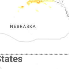
Nebraska
| Local Time | Report Details |
|---|---|
| 8:00 PM CDT | Quarter sized hail reported near Atkinson, NE, 25.4 miles NNW of Oneill, NE |
| 8:00 PM CDT | Quarter sized hail reported near Butte, NE, 27 miles NNW of Oneill, NE |
| 8:20 PM CDT | Quarter sized hail reported near Bristow, NE, 26.5 miles N of Oneill, NE |
Nevada
| Local Time | Report Details |
|---|---|
| 6:43 PM PDT | Mesonet station mpvn2 martin creek station elevation: 6438 f in humboldt county NV, 53.6 miles NNE of Winnemucca, NV |
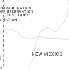
New Mexico
| Local Time | Report Details |
|---|---|
| 8:00 PM MDT | Quarter sized hail reported near Ribera, NM, 74.1 miles E of Albuquerque, NM, dime to quarter size hail. |
South Dakota
| Local Time | Report Details |
|---|---|
| 9:15 PM CDT | Quarter sized hail reported near Avon, SD, 42.3 miles NE of Oneill, NE, reported heavy lightning and quarter inch hail. |
| 10:05 PM CDT | Quarter sized hail reported near Yankton, SD, 59.1 miles SW of Sioux Falls, SD, social media report with picture of 1 inch hail. time reported by observer... aligns with radar data. |
Utah
| Local Time | Report Details |
|---|---|
| 10:08 PM MDT | Storm damage reported in salt lake county UT, 3.8 miles W of Salt Lake City, UT |
| 10:10 PM MDT | Utmv2 sensor in salt lake county UT, 7.9 miles WSW of Salt Lake City, UT |
| 10:30 PM MDT | Freut sensor in weber county UT, 35.5 miles NW of Salt Lake City, UT |
Connect with Interactive Hail Maps