

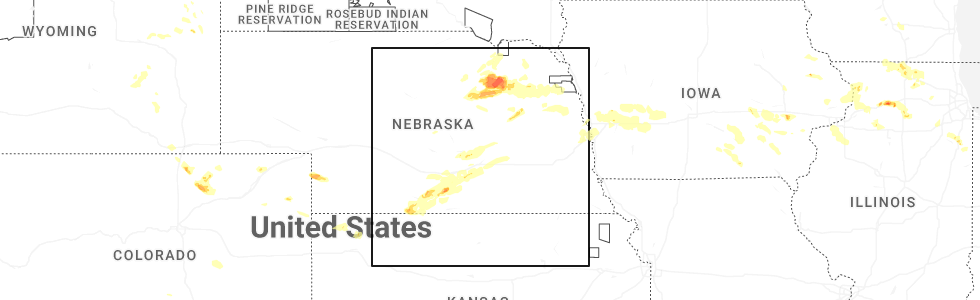
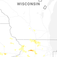
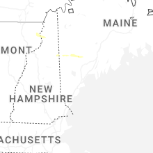
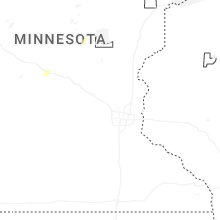
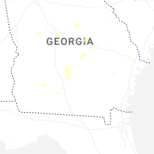
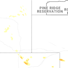
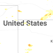
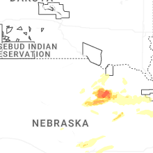
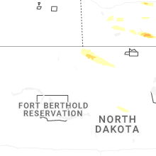
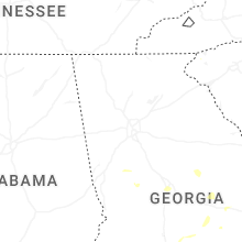
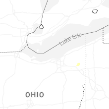
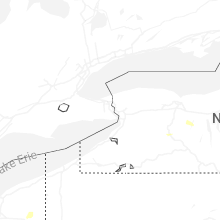
Hail Map for Thursday, July 10, 2025
Number of Impacted Households on 7/10/2025
0
Impacted by 1" or Larger Hail
0
Impacted by 1.75" or Larger Hail
0
Impacted by 2.5" or Larger Hail
Square Miles of Populated Area Impacted on 7/10/2025
0
Impacted by 1" or Larger Hail
0
Impacted by 1.75" or Larger Hail
0
Impacted by 2.5" or Larger Hail
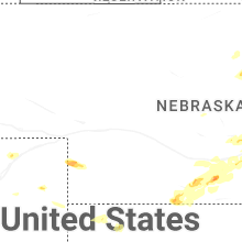
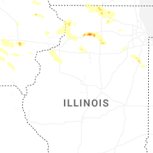
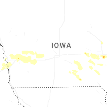

Cities Most Affected by Hail Storms of 7/10/2025
| Hail Size | Demographics of Zip Codes Affected | ||||||
|---|---|---|---|---|---|---|---|
| City | Count | Average | Largest | Pop Density | House Value | Income | Age |
| Maxbass, ND | 2 | 2.13 | 2.50 | 1 | $14k | $31.0k | 48.6 |
| Dixon, IL | 2 | 1.88 | 2.00 | 144 | $83k | $41.1k | 42.3 |
| Newburg, ND | 1 | 2.50 | 2.50 | 1 | $34k | $27.1k | 41.8 |
| Franklin Grove, IL | 1 | 2.00 | 2.00 | 24 | $87k | $41.7k | 43.2 |
| Earlville, IL | 1 | 2.00 | 2.00 | 22 | $98k | $46.4k | 39.5 |
| Wilcox, NE | 1 | 1.75 | 1.75 | 3 | $59k | $35.0k | 47.4 |
| Neligh, NE | 1 | 1.75 | 1.75 | 15 | $53k | $30.7k | 48.2 |
| Westhope, ND | 1 | 1.75 | 1.75 | 2 | $24k | $28.1k | 49.5 |
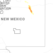
| Grenville, NM | 1 | 1.75 | 1.75 | 0 | $103k | $26.3k | 46.3 |
| Minden, NE | 1 | 1.75 | 1.75 | 12 | $77k | $40.3k | 44.2 |
| Clinton, IA | 1 | 1.75 | 1.75 | 249 | $62k | $34.7k | 40.7 |
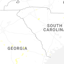
Hail and Wind Damage Spotted on 7/10/2025
Filter by Report Type:Hail ReportsWind Reports
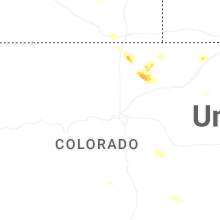
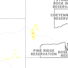
States Impacted
South Dakota, Colorado, South Carolina, Vermont, North Carolina, Ohio, Kansas, Nebraska, Illinois, Oklahoma, Georgia, Wisconsin, New Mexico, Iowa, New York, North Dakota, TexasSouth Dakota
| Local Time | Report Details |
|---|---|
| 8:21 AM MDT | Quarter sized hail reported near Piedmont, SD, 14.3 miles NW of Rapid City, SD |
| 9:56 AM MDT | Storm damage reported in pennington county SD, 36.4 miles E of Rapid City, SD |
Colorado
| Local Time | Report Details |
|---|---|
| 10:45 AM MDT | Mesonet station gw3678 pueblo wes in pueblo county CO, 9.1 miles NW of Pueblo, CO |
| 1:46 PM MDT | National wind technology cente in jefferson county CO, 14.9 miles NW of Denver, CO |
| 1:55 PM MDT | Mesonet station dvi09234 arvad in jefferson county CO, 12.7 miles WNW of Denver, CO |
| 2:16 PM MDT | Cdot weather sensor i-25 and washingto in denver county CO, 2.8 miles NNE of Denver, CO |
| 2:17 PM MDT | Cdot weather sensor at i-25 and york s in denver county CO, 3.2 miles NNE of Denver, CO |
| 2:17 PM MDT | Mesonet station co205 denver i-70/colorad in denver county CO, 3.6 miles NE of Denver, CO |
| 2:30 PM MDT | Mesonet station e470 & 6th avenu in arapahoe county CO, 14.6 miles E of Denver, CO |
| 2:42 PM MDT | Storm damage reported in denver county CO, 19.2 miles ENE of Denver, CO |
| 3:24 PM MDT | Storm damage reported in kit carson county CO, 54.7 miles SSW of Yuma, CO |
| 3:25 PM MDT | Storm damage reported in el paso county CO, 52.1 miles SSE of Denver, CO |
| 3:39 PM MDT | Storm damage reported in el paso county CO, 48 miles N of Pueblo, CO |
| 3:46 PM MDT | Storm damage reported in el paso county CO, 44.6 miles N of Pueblo, CO |
| 4:30 PM MDT | Storm damage reported in yuma county CO, 9 miles SSE of Yuma, CO |
| 4:30 PM MDT | Storm damage reported in kit carson county CO, 65 miles SSE of Yuma, CO |
| 8:42 PM MDT | Site rmr ranch measured a 76 mph wind gus in yuma county CO, 9.3 miles SE of Yuma, CO |
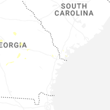
South Carolina
| Local Time | Report Details |
|---|---|
| 2:10 PM EDT | Quarter sized hail reported near Salem, SC, 24.8 miles WNW of Greenville, SC |
| 5:05 PM EDT | Tree fell on a vehicle near brimfield drive and west church stree in spartanburg county SC, 46.2 miles ENE of Greenville, SC |
| 5:38 PM EDT | Emergency manager reports trees down near the intersection of charleston highway and stonewall jackson blv in orangeburg county SC, 52 miles WNW of Charleston, SC |
| 5:40 PM EDT | Emergency manager reports roof damage to multiple buildings at 1098 joe s jeffords highwa in orangeburg county SC, 51.4 miles WNW of Charleston, SC |
| 6:03 PM EDT | The jasper county warning point reported a tree down on a power line on bellinger hill roa in jasper county SC, 6.3 miles NE of Savannah, GA |
| 7:20 PM EDT | Downed tree blocking the roadway at the intersection of browns ferry rd and pinewood d in georgetown county SC, 43.1 miles ENE of Charleston, SC |
| 8:00 PM EDT | Tree in roadway on egg hill r in florence county SC, 56.7 miles NE of Charleston, SC |
| 8:03 PM EDT | Tree in roadway on enoch rd in horry county SC, 70.3 miles NE of Charleston, SC |
| 8:07 PM EDT | Tree in roadway on s6 in horry county SC, 67.9 miles WSW of Wilmington, NC |
| 8:20 PM EDT | Tree in roadway on sc41 in horry county SC, 60.9 miles W of Wilmington, NC |
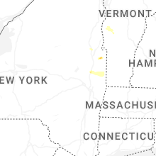
Vermont
| Local Time | Report Details |
|---|---|
| 2:43 PM EDT | Quarter sized hail reported near Orleans, VT, 55.6 miles ENE of Burlington, VT, photo received from the town clerk. |
| 3:25 PM EDT | Multiple trees down on vermont 17 in addison county VT, 26 miles S of Burlington, VT |
| 3:35 PM EDT | Broken pole with wires dow in addison county VT, 27.3 miles S of Burlington, VT |
| 4:27 PM EDT | Multiple trees down on route 125 in addison county VT, 32.2 miles S of Burlington, VT |
| 4:32 PM EDT | Trees and wires down in middlebur in addison county VT, 32.3 miles S of Burlington, VT |
| 4:36 PM EDT | Roof damage to middlebury high school and a tree dow in addison county VT, 32.3 miles S of Burlington, VT |
| 5:57 PM EDT | Tree down onto south hill road in williamstow in orange county VT, 43.5 miles SE of Burlington, VT |
| 6:24 PM EDT | Tree into power lines on route 100 north of hyde par in lamoille county VT, 33.9 miles ENE of Burlington, VT |
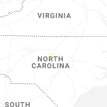
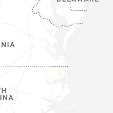
North Carolina
| Local Time | Report Details |
|---|---|
| 3:10 PM EDT | Tree downed onto a power pole on bells island rd. and nc-16 in currituck county NC, 22.2 miles SSE of Virginia Beach, VA |
| 3:50 PM EDT | Tree downed on perkins r in camden county NC, 32.1 miles S of Virginia Beach, VA |
| 6:50 PM EDT | Several hundred outages due to trees down on power line in wake county NC, 1.6 miles WNW of Raleigh, NC |
| 7:06 PM EDT | Tree uprooted and downed partially on a hom in wake county NC, 6.1 miles SSW of Raleigh, NC |
| 7:30 PM EDT | A few hundred outages due to trees down on powerline in lee county NC, 42 miles SW of Raleigh, NC |
| 7:41 PM EDT | Several outages due to fallen trees on power line in johnston county NC, 15.1 miles ESE of Raleigh, NC |
Ohio
| Local Time | Report Details |
|---|---|
| 3:47 PM EDT | Local public safety scanner reported multiple trees and wires down across central portage county. time estimated via rada in portage county OH, 33.4 miles SE of Cleveland, OH |
| 3:48 PM EDT | Tree down across state route in portage county OH, 35.7 miles SE of Cleveland, OH |
| 4:05 PM EDT | Tree down on wire on west lake blvd between greenwood and merrill. time estimated via rada in portage county OH, 28.3 miles SE of Cleveland, OH |
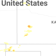
Kansas
| Local Time | Report Details |
|---|---|
| 3:05 PM CDT | Quarter sized hail reported near Scott City, KS, 22.7 miles NNW of Garden City, KS |
| 3:33 PM CDT | Quarter sized hail reported near Ulysses, KS, 37.8 miles SW of Garden City, KS |
| 3:35 PM CDT | Awos station kuls ulysse in grant county KS, 37.3 miles SW of Garden City, KS |
| 3:57 PM CDT | Storm damage reported in finney county KS, 3.2 miles ENE of Garden City, KS |
| 4:03 PM CDT | Storm damage reported in finney county KS, 0.7 miles SSW of Garden City, KS |
| 6:41 PM CDT | Mesonet station up840 9.0 w winona (upr in logan county KS, 33.1 miles SW of Colby, KS |
| 6:57 PM CDT | Social media report of wind gusts up to 70 mp in thomas county KS, 6.4 miles WSW of Colby, KS |
| 6:09 PM MDT | Report from mesonet statio in hamilton county KS, 47.3 miles W of Garden City, KS |
| 6:15 PM MDT | Awos station k3k3 syracus in hamilton county KS, 47.9 miles W of Garden City, KS |
| 6:15 PM MDT | Mesonet k5co in hamilton county KS, 62.2 miles W of Garden City, KS |
| 7:18 PM CDT | Media storm chaser is reporting gusts of 50 to 60 mp in thomas county KS, 4 miles W of Colby, KS |
| 7:30 PM CDT | Storm damage reported in kearny county KS, 35.4 miles W of Garden City, KS |
| 7:31 PM CDT | Mesonet d528 in kearny county KS, 35.4 miles W of Garden City, KS |
| 7:38 PM CDT | Ambient weather network site nwkecount in kearny county KS, 29.4 miles WNW of Garden City, KS |
| 7:39 PM CDT | Personal weather station kkslakin2 in kearny county KS, 32.1 miles WNW of Garden City, KS |
| 7:47 PM CDT | Site landfill office measure 58 mph wind gus in thomas county KS, 2.5 miles ESE of Colby, KS |
| 7:55 PM CDT | Awos station k36k 2 n laki in kearny county KS, 20.6 miles W of Garden City, KS |
| 7:55 PM CDT | Awos station kjhn johnson cit in stanton county KS, 54.1 miles WSW of Garden City, KS |
| 8:01 PM CDT | Storm damage reported in scott county KS, 27.6 miles N of Garden City, KS |
| 8:10 PM CDT | Ambient weather network site videra_weathe in grant county KS, 36.8 miles SW of Garden City, KS |
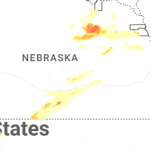
Nebraska
| Local Time | Report Details |
|---|---|
| 3:27 PM CDT | Via davis weather statio in harlan county NE, 80.2 miles SW of Grand Island, NE |
| 3:35 PM CDT | Quarter sized hail reported near Orleans, NE, 75.2 miles SW of Grand Island, NE |
| 4:45 PM CDT | Downed tree branches up to 7-8 inches in diamete in hall county NE, 10.3 miles WNW of Grand Island, NE |
| 5:40 PM CDT | Golf Ball sized hail reported near Neligh, NE, 40 miles ESE of Oneill, NE |
| 5:57 PM CDT | Half Dollar sized hail reported near Genoa, NE, 55.1 miles NE of Grand Island, NE, report from mping: half dollar (1.25 in.). |
| 5:57 PM CDT | Ping Pong Ball sized hail reported near Genoa, NE, 55.1 miles NE of Grand Island, NE, report from mping: ping pong ball (1.50 in.). |
| 5:58 PM CDT | Half Dollar sized hail reported near Genoa, NE, 54 miles NE of Grand Island, NE, report from mping: half dollar (1.25 in.). |
| 6:04 PM CDT | Video of approximately 18 inch diameter tree limb down. time estimated from rada in antelope county NE, 50.5 miles ESE of Oneill, NE |
| 6:15 PM CDT | Quarter sized hail reported near Wilcox, NE, 58 miles SW of Grand Island, NE |
| 6:15 PM CDT | Reports of structural damage and several reports of tree damage around town... primarily on the north side of tow in hall county NE, 5.7 miles NW of Grand Island, NE |
| 6:17 PM CDT | Storm damage reported in hall county NE, 3.5 miles NNE of Grand Island, NE |
| 6:17 PM CDT | Quarter sized hail reported near Humphrey, NE, 70.1 miles NE of Grand Island, NE, report from mping: quarter (1.00 in.). |
| 6:18 PM CDT | Quarter sized hail reported near Humphrey, NE, 70.1 miles NE of Grand Island, NE, report from mping: quarter (1.00 in.). |
| 6:20 PM CDT | Quarter sized hail reported near Wilcox, NE, 58 miles SW of Grand Island, NE |
| 6:22 PM CDT | Golf Ball sized hail reported near Wilcox, NE, 58.5 miles SW of Grand Island, NE, ping pong to golf ball size hail at its peak caused damage to siding. |
| 6:27 PM CDT | Via davis weather statio in kearney county NE, 49 miles SW of Grand Island, NE |
| 6:29 PM CDT | Via davis weather statio in kearney county NE, 46.6 miles SW of Grand Island, NE |
| 6:35 PM CDT | Via davis weather statio in kearney county NE, 44.3 miles SW of Grand Island, NE |
| 6:37 PM CDT | Golf Ball sized hail reported near Minden, NE, 43.4 miles SW of Grand Island, NE, social media report of quarters with a few goofball sized hail in town. |
| 6:37 PM CDT | Tree blown over onto house just south of the high school. time estimated from radar and nearby mesonet report in kearney county NE, 43.8 miles SW of Grand Island, NE |
| 6:50 PM CDT | Social media report of several turned pivots as well as damage to a nearby grain sil in adams county NE, 24.6 miles SW of Grand Island, NE |
| 6:51 PM CDT | Mesonet hayln in adams county NE, 21.9 miles SSW of Grand Island, NE |
| 6:55 PM CDT | Image from social media of snapped power pole in hall county NE, 17.6 miles SSW of Grand Island, NE |
| 6:55 PM CDT | 8-10 inch in diameter tree branch limbs dow in adams county NE, 21.3 miles SSW of Grand Island, NE |
| 6:56 PM CDT | Mesonet site hayln1. supported by radar data of a potential microburst in this are in adams county NE, 21.9 miles SSW of Grand Island, NE |
| 7:04 PM CDT | Storm damage reported in adams county NE, 18.7 miles SSW of Grand Island, NE |
| 7:08 PM CDT | Quarter sized hail reported near Doniphan, NE, 14.6 miles SSW of Grand Island, NE, delayed report. report from mping: quarter (1.00 in.). |
| 7:12 PM CDT | Peak gust of 63 mph measured by aso in madison county NE, 69.9 miles ESE of Oneill, NE |
| 7:12 PM CDT | Off duty nws employee reporting 50-60 mph wind gus in adams county NE, 23.5 miles S of Grand Island, NE |
| 7:14 PM CDT | Storm damage reported in hamilton county NE, 15.6 miles ESE of Grand Island, NE |
| 7:23 PM CDT | Storm damage reported in hamilton county NE, 18.9 miles ESE of Grand Island, NE |
| 7:36 PM CDT | Storm damage reported in hamilton county NE, 24.7 miles E of Grand Island, NE |
| 7:45 PM CDT | Personal weather statio in antelope county NE, 46.7 miles SE of Oneill, NE |
| 7:50 PM CDT | Quarter sized hail reported near Wilcox, NE, 58 miles SW of Grand Island, NE |
| 7:50 PM CDT | Storm damage reported in furnas county NE, 81.5 miles WSW of Grand Island, NE |
| 8:20 PM CDT | Storm damage reported in phelps county NE, 61.9 miles WSW of Grand Island, NE |
| 8:25 PM CDT | Report of 18 inch in diameter tree branch dow in phelps county NE, 64.1 miles WSW of Grand Island, NE |
| 8:54 PM CDT | Via personal weather statio in kearney county NE, 38.6 miles WSW of Grand Island, NE |
| 9:12 PM CDT | A few tree limbs down in tow in buffalo county NE, 29.3 miles WSW of Grand Island, NE |
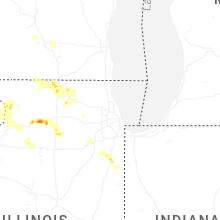
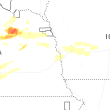
Illinois
| Local Time | Report Details |
|---|---|
| 3:28 PM CDT | Golf Ball sized hail reported near Dixon, IL, 77.8 miles N of Peoria, IL |
| 3:33 PM CDT | Half Dollar sized hail reported near Dixon, IL, 77.8 miles N of Peoria, IL |
| 3:56 PM CDT | Ping Pong Ball sized hail reported near Dixon, IL, 79.5 miles N of Peoria, IL |
| 4:07 PM CDT | Ping Pong Ball sized hail reported near Dixon, IL, 78.7 miles N of Peoria, IL, report from mping: ping pong ball (1.50 in.). |
| 4:14 PM CDT | Half Dollar sized hail reported near Dixon, IL, 80.2 miles N of Peoria, IL, report from mping: half dollar (1.25 in.). |
| 4:17 PM CDT | Hen Egg sized hail reported near Franklin Grove, IL, 79.9 miles N of Peoria, IL, report from mping: hen egg (2.00 in.). time estimated by radar. |
| 4:27 PM CDT | Hen Egg sized hail reported near Dixon, IL, 79.8 miles N of Peoria, IL, report from mping: hen egg (2.00 in.). |
| 4:47 PM CDT | Quarter sized hail reported near Loves Park, IL, 54.1 miles SSE of Madison, WI, time estimated by radar. |
| 4:55 PM CDT | Quarter sized hail reported near Rockford, IL, 57.4 miles SSE of Madison, WI, report from mping: quarter (1.00 in.). |
| 4:56 PM CDT | Up to 6 diameter limbs down near brooklyn rd on rt 30. corn fields also have corn blown at 35 to 40 degree angle in lee county IL, 77.1 miles NNE of Peoria, IL |
| 5:05 PM CDT | Ping Pong Ball sized hail reported near Rockford, IL, 55.9 miles SSE of Madison, WI, heavy hail from 5:00-5:10 pm. varied in size with largest piece being 1.5in measured. no injuries and no obvious damage at this time. |
| 5:10 PM CDT | Ping Pong Ball sized hail reported near Machesney Park, IL, 52.9 miles SSE of Madison, WI |
| 5:10 PM CDT | Quarter sized hail reported near Rockford, IL, 56.4 miles SSE of Madison, WI, report from mping: quarter (1.00 in.). |
| 5:13 PM CDT | Quarter sized hail reported near Rockford, IL, 57.2 miles SSE of Madison, WI |
| 5:20 PM CDT | Multiple trees and power lines downed in cherry valley and on the southeast side of rockford. time estimated from rada in winnebago county IL, 61.1 miles SSE of Madison, WI |
| 5:27 PM CDT | Quarter sized hail reported near Paw Paw, IL, 73.2 miles W of Chicago, IL, report from mping: quarter (1.00 in.). |
| 5:42 PM CDT | Hen Egg sized hail reported near Earlville, IL, 71.8 miles WSW of Chicago, IL |
| 5:55 PM CDT | 6 inch tree limb downed on dietrich road in hampshire. time estimated via rada in kane county IL, 48.8 miles WNW of Chicago, IL |
| 5:55 PM CDT | Downed power lines resulting in power outages in the 100 block of terwilliger avenue. time estimated by rada in kane county IL, 49 miles WNW of Chicago, IL |
| 6:03 PM CDT | Large branch of a bradford pear tree snapped. time estimated by rada in kendall county IL, 39.4 miles SW of Chicago, IL |
| 7:12 PM CDT | Dispatch reported multiple power poles and wires down... leading to portions of route 84 being closed. along the same route... reports of several farm irrigators being in carroll county IL, 81.1 miles E of Cedar Rapids, IA |
| 7:20 PM CDT | 70 foot repeater tower knocked down due to high wind in carroll county IL, 77.7 miles SSW of Madison, WI |
| 7:25 PM CDT | Half Dollar sized hail reported near Savanna, IL, 78.1 miles SSW of Madison, WI |
| 7:30 PM CDT | Report of numerous power lines down... power poles snapped... and trees down across roads. this damage is widespread throughout the are in carroll county IL, 74.3 miles SSW of Madison, WI |
| 7:35 PM CDT | 5 downed power poles at 9000n and 3250w west of manten in kankakee county IL, 46.6 miles SSW of Chicago, IL |
| 7:40 PM CDT | Quarter sized hail reported near Savanna, IL, 76.4 miles SSW of Madison, WI, quarter sized hail lasting for about ten minutes. |
| 7:40 PM CDT | Report of a lot of trees down throughout this are in carroll county IL, 76.4 miles SSW of Madison, WI |
| 7:52 PM CDT | Measured at a personal weather station on the northwest side of manten in kankakee county IL, 44.7 miles SSW of Chicago, IL |
| 8:11 PM CDT | Half Dollar sized hail reported near Bourbonnais, IL, 50.2 miles S of Chicago, IL, mping report of half dollar sized hail. |
| 10:20 PM CDT | Media in kewanee relayed a henry county sheriffs office report of a tree down on county highway 5 north of highway 81. time estimated by rada in henry county IL, 50.9 miles NNW of Peoria, IL |
| 10:53 PM CDT | Depue fire reported trees and limbs down throughout town... some of which were blocking roadways. they also reported minor flooding. time estimated by rada in bureau county IL, 46.5 miles NNE of Peoria, IL |
Oklahoma
| Local Time | Report Details |
|---|---|
| 3:40 PM CDT | The first severe gust occurred at 3:35 pm and the final gust occurred at 3:45 pm. the peak was 67 mp in texas county OK, 87.9 miles SW of Garden City, KS |
| 6:02 PM CDT | Em reported windows knocked out of two cars in felt. supports downburst with winds likely over 80 mp in cimarron county OK, 107.9 miles NNW of Amarillo, TX |
| 6:05 PM CDT | A downburst event occurred near a feed lot 3 miles north of felt and affected some parts surrounding. roofs at the lot and at surrounding houses were torn but not compl in cimarron county OK, 110.6 miles NNW of Amarillo, TX |
| 6:35 PM CDT | Storm damage reported in cimarron county OK, 108.8 miles NNW of Amarillo, TX |
Georgia
| Local Time | Report Details |
|---|---|
| 5:21 PM EDT | Several downed trees and powerlines on legg r in turner county GA, 43.5 miles WNW of Douglas, GA |
| 5:22 PM EDT | Social media video showed a thunderstorm wind gust snapping several large limbs off a tree onto a driveway of a home. time determined using radar dat in chatham county GA, 12.5 miles WNW of Savannah, GA |
| 5:39 PM EDT | A severe thunderstorm downed a power line at the 2100 block of krenson street. time determined from radar dat in chatham county GA, 1.8 miles WNW of Savannah, GA |
| 5:46 PM EDT | A severe thunderstorm downed a power line at the 300 block of beaufort road. time determined from radar dat in chatham county GA, 11.6 miles SW of Savannah, GA |
| 5:49 PM EDT | Trees dow in ben hill county GA, 27.8 miles WNW of Douglas, GA |
| 5:55 PM EDT | Powerline reported down on elm street. time determined from radar dat in chatham county GA, 1.4 miles NNW of Savannah, GA |
| 6:00 PM EDT | A severe thunderstorm downed a power line near the 3200 block of cedar street. time determined using radar dat in chatham county GA, 4.8 miles SSE of Savannah, GA |
| 6:00 PM EDT | Downed trees reported in tift count in tift county GA, 35.3 miles W of Douglas, GA |
| 6:01 PM EDT | Downed trees on whitley stree in irwin county GA, 29.6 miles WNW of Douglas, GA |
| 6:02 PM EDT | A severe thunderstorm downed a power line near the intersection of coffee bluff road and ben kell road. time determined from radar dat in chatham county GA, 10.1 miles SSW of Savannah, GA |
| 6:10 PM EDT | Chatham county em reported downed powerlines across the county. police scanner broadcast within the city of savannah reported a tree blocking a road and at least one tr in chatham county GA, 2.2 miles SSE of Savannah, GA |
| 6:16 PM EDT | Delayed report. wayne county dispatch reported a tree down on west lake dr and griffis r in wayne county GA, 48 miles E of Douglas, GA |
| 6:25 PM EDT | Tree down near 3300 stallings roa in lowndes county GA, 47.1 miles SSW of Douglas, GA |
Wisconsin
| Local Time | Report Details |
|---|---|
| 4:40 PM CDT | Pictures from social media indicating numerous large branches down across town. time estimated from rada in dane county WI, 8.9 miles NNW of Madison, WI |
New Mexico
| Local Time | Report Details |
|---|---|
| 3:44 PM MDT | Golf Ball sized hail reported near Grenville, NM, 87.8 miles N of Tucumcari, NM |
| 4:15 PM MDT | Lots of blowing dust kicked up with reduced visibilit in union county NM, 106.6 miles NNE of Tucumcari, NM |
| 5:35 PM MDT | Awos station ksxu santa rosa airpor in guadalupe county NM, 54.4 miles WSW of Tucumcari, NM |
| 6:35 PM MDT | Mesonet station wsm34 stallion wit (wsmr in socorro county NM, 101 miles S of Albuquerque, NM |
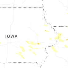
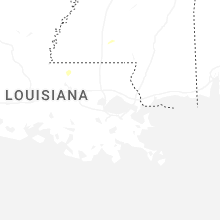
Iowa
| Local Time | Report Details |
|---|---|
| 5:35 PM CDT | There was a 6-8 inch tree trunk snapped by thunderstorm wind in johnson county IA, 24.7 miles SSE of Cedar Rapids, IA |
| 5:37 PM CDT | Quarter sized hail reported near Iowa City, IA, 22.9 miles SSE of Cedar Rapids, IA |
| 7:48 PM CDT | Couple trees downed. one 2-3 feet in diameter downed onto a vehicl in clinton county IA, 77.3 miles E of Cedar Rapids, IA |
| 9:17 PM CDT | Golf Ball sized hail reported near Clinton, IA, 75 miles E of Cedar Rapids, IA, location and time estimated by radar. |
| 10:49 PM CDT | Storm damage reported in shelby county IA, 38.2 miles NE of Omaha, NE |
| 11:45 PM CDT | Tree damage across much of the cit in guthrie county IA, 46.2 miles W of Des Moines, IA |
| 11:45 PM CDT | Tree damage across much of the cit in adair county IA, 47.9 miles WSW of Des Moines, IA |
| 11:45 PM CDT | Tree damage across much of the are in guthrie county IA, 40.9 miles W of Des Moines, IA |
| 11:50 PM CDT | Large tree limb dow in guthrie county IA, 46.2 miles W of Des Moines, IA |
| 5:13 AM UTC | Healthy... mature tree knocked over. numerous large 6+ diameter limbs snapped off als in audubon county IA, 59.6 miles ENE of Omaha, NE |
| 12:33 AM CDT | Estimated 50-60mph gust in dallas county IA, 19.1 miles WNW of Des Moines, IA |
| 12:38 AM CDT | Estimated 60-70 mph gusts on the west side of tow in dallas county IA, 14.3 miles W of Des Moines, IA |
| 12:39 AM CDT | Two sustained gusts to 70 mph at 1237 and 1240 a in dallas county IA, 9.6 miles W of Des Moines, IA |
| 12:45 AM CDT | Mature tree snapped in ewing park. time of occurrence estimated from rada in polk county IA, 3.9 miles SSE of Des Moines, IA |
| 12:46 AM CDT | Storm damage reported in polk county IA, 7.5 miles W of Des Moines, IA |
| 12:49 AM CDT | 64 knot gust dsm airpor in polk county IA, 4.7 miles SSW of Des Moines, IA |
| 1:08 AM CDT | 52 knot gust ankeny airpor in polk county IA, 7.3 miles NNE of Des Moines, IA |
| 1:28 AM CDT | Storm damage reported in polk county IA, 8.2 miles ENE of Des Moines, IA |
New York
| Local Time | Report Details |
|---|---|
| 6:59 PM EDT | Storm damage reported in warren county NY, 40.1 miles NNE of Schenectady, NY |
| 7:25 PM EDT | Quarter sized hail reported near Saratoga Springs, NY, 18.9 miles NNE of Schenectady, NY |
| 7:27 PM EDT | Tree downed on the northway southbound within the area of exit 14... new york route 9p and new york route 29 in saratoga spring in saratoga county NY, 20.3 miles NNE of Schenectady, NY |
| 8:09 PM EDT | Several trees reported down throughout the town of cambridge... some of which occurred along center cambridge roa in washington county NY, 32.2 miles ENE of Schenectady, NY |
| 8:17 PM EDT | Trees and wires reported down in hoosick fall in rensselaer county NY, 30.6 miles ENE of Schenectady, NY |
| 8:17 PM EDT | Wires reported down on lincoln hill road in the town of white cree in washington county NY, 33.6 miles ENE of Schenectady, NY |
| 8:28 PM EDT | Social media report received of a tree down on a fence along liz ann drive near saratoga spring in saratoga county NY, 22 miles NNE of Schenectady, NY |
North Dakota
| Local Time | Report Details |
|---|---|
| 6:30 PM CDT | Tennis Ball sized hail reported near Maxbass, ND, 36.8 miles N of Minot, ND |
| 6:32 PM CDT | Golf Ball sized hail reported near Westhope, ND, 41.4 miles NNE of Minot, ND, broadcast media relayed report with picture. |
| 6:40 PM CDT | Golf Ball sized hail reported near Maxbass, ND, 36.6 miles NNE of Minot, ND, softer hail... lasted 3 minutes. |
| 6:52 PM CDT | Tennis Ball sized hail reported near Newburg, ND, 37.8 miles NNE of Minot, ND, broadcast media relayed delayed report. |
Texas
| Local Time | Report Details |
|---|---|
| 6:44 PM CDT | Storm damage reported in hartley county TX, 69.6 miles NW of Amarillo, TX |
Connect with Interactive Hail Maps