

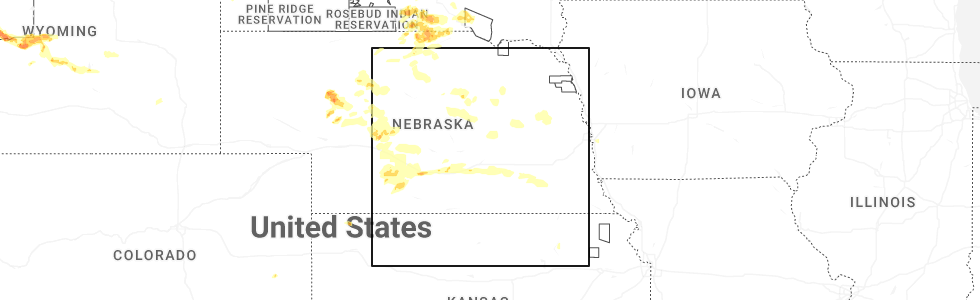
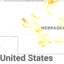
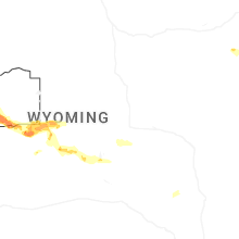
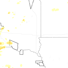
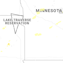
Hail Map for Tuesday, July 15, 2025
Number of Impacted Households on 7/15/2025
0
Impacted by 1" or Larger Hail
0
Impacted by 1.75" or Larger Hail
0
Impacted by 2.5" or Larger Hail
Square Miles of Populated Area Impacted on 7/15/2025
0
Impacted by 1" or Larger Hail
0
Impacted by 1.75" or Larger Hail
0
Impacted by 2.5" or Larger Hail

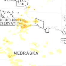
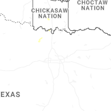
Cities Most Affected by Hail Storms of 7/15/2025
| Hail Size | Demographics of Zip Codes Affected | ||||||
|---|---|---|---|---|---|---|---|
| City | Count | Average | Largest | Pop Density | House Value | Income | Age |
| Hyannis, NE | 1 | 2.00 | 2.00 | 0 | $33k | $31.8k | 49.9 |
Hail and Wind Damage Spotted on 7/15/2025
Filter by Report Type:Hail ReportsWind Reports
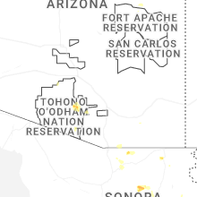
States Impacted
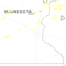
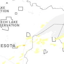
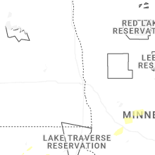
Minnesota, Utah, Wyoming, Nebraska, Virginia, Wisconsin, Nevada, Idaho, North Carolina, South Dakota, Georgia, Florida, Alabama, Oklahoma, KansasMinnesota
| Local Time | Report Details |
|---|---|
| 8:20 AM CDT | Quarter sized hail reported near Finlayson, MN, 57.7 miles SW of Duluth, MN |
| 8:21 AM CDT | Quarter sized hail reported near Finlayson, MN, 57.4 miles SW of Duluth, MN, report via social media. time estimated from radar. |
| 8:25 AM CDT | Ping Pong Ball sized hail reported near Finlayson, MN, 56.4 miles SW of Duluth, MN, report via social media with photo. |
| 2:53 PM CDT | Asos station kaxn alexandria mn aso in douglas county MN, 65.3 miles NNE of Montevideo, MN |
| 3:09 PM CDT | Corrects previous tstm wnd dmg report from 4 nne nemadji. corrects previous tstm wnd dmg report from 4 nne nemadji. multiple trees and a flagpole were downed at the rep in carlton county MN, 27.9 miles SW of Duluth, MN |
| 4:09 PM CDT | Corrects previous tstm wnd dmg report from 4 nne nemadji. multiple trees and a flagpole were downed at the reporters location. time estimated by rada in carlton county MN, 27.9 miles SW of Duluth, MN |
| 4:12 PM CDT | Public report of trees down near us10 south of motley. relayed via county dispatc in todd county MN, 85.8 miles S of Bemidji, MN |
| 4:15 PM CDT | Delayed report of large branch snapped off a willow tree near darling township. photo shared via facebook. time estimated from rada in morrison county MN, 94.8 miles NW of Minneapolis, MN |
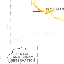
Utah
| Local Time | Report Details |
|---|---|
| 8:10 AM MDT | Mesonet station utncc i-15 at mp 62 n cedar city. likely a dry microburst from a low-reflectivity shower moving over the sit in iron county UT, 51.9 miles NE of Saint George, UT |
| 3:44 PM MDT | Asos station kvel vernal rgnl airport. convective outflow wind from distant thunderstorm in uintah county UT, 79.9 miles SSW of Rock Springs, WY |
| 3:50 PM MDT | Measured wind gust of 63 mph at salt flats mesonet sensor (dpg15 in tooele county UT, 76.6 miles WSW of Salt Lake City, UT |
| 4:10 PM MDT | Measured wind gust of 63 mph at us-6 at mp 296 sphinx siding mesonet sensor (utspx in emery county UT, 48.8 miles SE of Price, UT |
| 5:40 PM MDT | Measured wind gust of 61 mph at baccus/sr111 mesonet sensor (bac in salt lake county UT, 12.2 miles SW of Salt Lake City, UT |
| 6:00 PM MDT | Measured wind gust of 58 mph at sr-30 @ curlew mesonet sensor (utcur in box elder county UT, 82.6 miles ESE of Twin Falls, ID |
| 6:00 PM MDT | Measured wind gust of 66 mph at i-15 @ mp 169 mesonet station (utcir in millard county UT, 28.5 miles NNW of Monroe, UT |
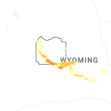
Wyoming
| Local Time | Report Details |
|---|---|
| 10:35 AM MDT | Mesonet station av868 medicine butte mountain. likely dry microburst associated with a weak line of shower in uinta county WY, 65.3 miles NE of Salt Lake City, UT |
| 10:40 AM MDT | Mesonet station pc450 evanston north. likely dry microburst associated with a weak line of shower in uinta county WY, 65.8 miles NE of Salt Lake City, UT |
| 2:09 PM MDT | Mesonet station up098 sage junction 2.7 e (upr in lincoln county WY, 88.6 miles NE of Salt Lake City, UT |
| 3:30 PM MDT | Storm damage reported in fremont county WY, 72.8 miles WNW of Riverton, WY |
| 3:53 PM MDT | Corrects previous non-tstm wnd gst report from 2 n marbleton. asos station kbpi big piney airpor in sublette county WY, 82.1 miles NNW of Rock Springs, WY |
| 3:57 PM MDT | Mesonet station elkw4 elkhor in fremont county WY, 76.7 miles NW of Riverton, WY |
| 4:20 PM MDT | Mesonet station pc452 cottonwood mern in sublette county WY, 98 miles W of Riverton, WY |
| 5:08 PM MDT | Mesonet station kbit point of rocks 10.4 e (wydot in sweetwater county WY, 33.6 miles E of Rock Springs, WY |
| 7:15 PM MDT | Corrects previous non-tstm wnd gst report from 13 s thermopolis. awos station ktbx boysen pea in hot springs county WY, 31.7 miles NNE of Riverton, WY |
| 7:50 PM MDT | Mesonet station camw4 muddy gap 7 s in fremont county WY, 62.8 miles SE of Riverton, WY |
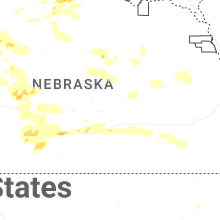
Nebraska
| Local Time | Report Details |
|---|---|
| 11:52 AM CDT | 8 inch diameter tree down near 103rd and blair high roa in douglas county NE, 7.9 miles WNW of Omaha, NE |
| 3:28 PM MDT | Hen Egg sized hail reported near Hyannis, NE, 77.2 miles NW of North Platte, NE |
| 5:14 PM CDT | Quarter sized hail reported near Springview, NE, 39.9 miles E of Valentine, NE, report from mping. |
| 5:19 PM CDT | Ping Pong Ball sized hail reported near Springview, NE, 39.7 miles E of Valentine, NE, report from mping. |
| 5:30 PM CDT | Ping Pong Ball sized hail reported near Springview, NE, 40.7 miles E of Valentine, NE |
| 5:49 PM CDT | Quarter sized hail reported near Springview, NE, 42.2 miles ESE of Valentine, NE |
| 5:57 PM CDT | Quarter sized hail reported near Ainsworth, NE, 41.9 miles ESE of Valentine, NE |
| 6:34 PM CDT | Pws-knedunni in blaine county NE, 58.1 miles NE of North Platte, NE |
| 7:34 PM CDT | Reports of 64 mph wind with large tree branches dow in logan county NE, 27.1 miles NNE of North Platte, NE |
| 7:38 PM CDT | Quarter sized hail reported near Stapleton, NE, 14.4 miles NNE of North Platte, NE |
| 9:20 PM CDT | Storm damage reported in greeley county NE, 44.3 miles NNW of Grand Island, NE |
| 10:22 PM CDT | Several trees uprooted and branches broke in butler county NE, 64.1 miles ENE of Grand Island, NE |
| 10:49 PM CDT | Storm damage reported in butler county NE, 53.1 miles W of Omaha, NE |
| 10:53 PM CDT | Storm damage reported in butler county NE, 56.9 miles W of Omaha, NE |
| 11:32 PM CDT | Storm damage reported in saunders county NE, 36.3 miles W of Omaha, NE |
| 11:35 PM CDT | Storm damage reported in saunders county NE, 34.4 miles W of Omaha, NE |
| 11:35 PM CDT | Storm damage reported in lancaster county NE, 51.3 miles WSW of Omaha, NE |
| 11:37 PM CDT | Personal weather statio in lancaster county NE, 52.4 miles WSW of Omaha, NE |
| 11:41 PM CDT | Personal weather statio in lancaster county NE, 44.6 miles WSW of Omaha, NE |
| 11:47 PM CDT | Personal weather statio in lancaster county NE, 47.6 miles SW of Omaha, NE |
| 11:47 PM CDT | Personal weather statio in lancaster county NE, 54.8 miles SW of Omaha, NE |
| 11:52 PM CDT | Corrects time of previous tstm wnd dmg report from 5 nw omaha. 8 inch diameter tree down near 103rd and blair high roa in douglas county NE, 7.9 miles WNW of Omaha, NE |
| 12:00 AM CDT | Powerlines dow in cass county NE, 33.3 miles SW of Omaha, NE |
| 12:01 AM CDT | Personal weather statio in douglas county NE, 8.2 miles NNW of Omaha, NE |
| 12:35 AM CDT | Quarter sized hail reported near Kearney, NE, 40.6 miles WSW of Grand Island, NE, reports of mostly dime to nickel size in kearney... isolated quarter size. |
| 1:15 AM CDT | Quarter sized hail reported near Kearney, NE, 42.3 miles WSW of Grand Island, NE, hail up to around quarter size reported in kearney. |
| 1:15 AM CDT | Ping Pong Ball sized hail reported near Kearney, NE, 41.8 miles WSW of Grand Island, NE, received photo via facebook of hail up to around ping pong ball size. |
Virginia
| Local Time | Report Details |
|---|---|
| 3:38 PM EDT | Report of a downed tree on elm roa in greensville county VA, 62 miles S of Richmond, VA |
| 5:12 PM EDT | Damage to roof and a greenhouse reporte in pulaski county VA, 51 miles WSW of Roanoke, VA |
| 7:58 PM EDT | Tree across power dam road blocking one lane of traffi in franklin county VA, 20 miles SSE of Roanoke, VA |
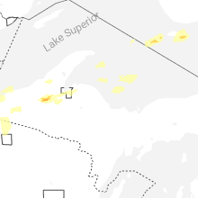
Wisconsin
| Local Time | Report Details |
|---|---|
| 2:55 PM CDT | A photo was received showing a tree down in ashland. time estimated by rada in ashland county WI, 59.1 miles ESE of Duluth, MN |
| 6:22 PM CDT | 18 inch diameter pine tree snapped 6 feet off the ground based on photo. time estimated by rada in washburn county WI, 67.6 miles S of Duluth, MN |
| 6:42 PM CDT | Tree on powerline and on fire. time estimated from rada in washburn county WI, 73.3 miles SSE of Duluth, MN |
| 8:20 PM CDT | Trees and power lines dow in vilas county WI, 32.5 miles NW of Rhinelander, WI |
| 8:41 PM CDT | Trees and power lines down. time estimated by rada in vilas county WI, 43.5 miles NNW of Rhinelander, WI |
Nevada
| Local Time | Report Details |
|---|---|
| 1:39 PM PDT | Station moor raws... elevation 6121 f in elko county NV, 57.5 miles ENE of Elko, NV |
| 2:26 PM PDT | Station crane springs raws... elevation 6414 f in elko county NV, 26.3 miles S of Elko, NV |
| 3:53 PM PDT | Station (kp68) eureka airport... elevation 5945 f in eureka county NV, 64.4 miles WNW of Ely, NV |
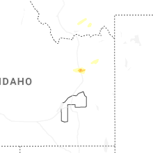
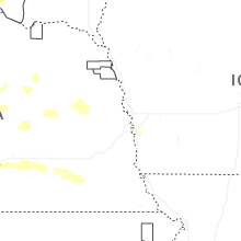
Idaho
| Local Time | Report Details |
|---|---|
| 2:40 PM MDT | Pacficorp medicine lodg in clark county ID, 57.4 miles NNW of Idaho Falls, ID |
| 2:40 PM MDT | Mesonet station pc371 medicine lodg in clark county ID, 61.3 miles NNW of Idaho Falls, ID |
| 2:45 PM MDT | Mesonet station grei 1 nw nite in caribou county ID, 68.8 miles SSE of Idaho Falls, ID |
| 2:45 PM MDT | Grace agrime in caribou county ID, 68.3 miles SSE of Idaho Falls, ID |
| 3:01 PM MDT | Knocked branches out of my trees and ripped the trop rail off my fence. blew deck furniture over. power outag in caribou county ID, 64.9 miles SSE of Idaho Falls, ID |
| 3:15 PM MDT | Greenhouse demolishe in fremont county ID, 49.7 miles NE of Idaho Falls, ID |
| 3:30 PM MDT | Mesonet station 3699 d6 inl puzzle us-20/us-2 in butte county ID, 42.6 miles W of Idaho Falls, ID |
| 4:25 PM MDT | Lightning struck a power pole at 4100 east 1400 north and started a fire that was later extinguished from the rain. power outages for the majority of the county south f in fremont county ID, 49.7 miles NE of Idaho Falls, ID |
| 5:15 PM MDT | Mesonet station 3004 d4 juniper interchange i-8 in oneida county ID, 81.5 miles ESE of Twin Falls, ID |
| 5:39 PM MDT | Mesonet station mofi1 moburg canyo in cassia county ID, 76.4 miles ESE of Twin Falls, ID |
| 6:00 PM MDT | Mesonet station 3010 d5 malad summit i-1 in oneida county ID, 80.1 miles S of Idaho Falls, ID |
| 6:00 PM MDT | Mesonet station 8833 d5 swan lake us-9 in bannock county ID, 79.5 miles S of Idaho Falls, ID |
| 6:00 PM MDT | Mesonet station pc497 station canyo in oneida county ID, 82.2 miles S of Idaho Falls, ID |
| 6:15 PM MDT | Mesonet station 5647 d5 mccammon interchange i-1 in bannock county ID, 58.1 miles S of Idaho Falls, ID |
| 6:25 PM MDT | Photo of very top of large evergreen tree snapped off and report of other branches down in the area. shared via social medi in caribou county ID, 53.8 miles S of Idaho Falls, ID |
| 6:30 PM MDT | Trained spotter relayed reports of downed power lines on philbin rd in chubbuc in bannock county ID, 45.8 miles SSW of Idaho Falls, ID |
| 6:35 PM MDT | Mesonet station for 2 e fort hal in bannock county ID, 37.5 miles SSW of Idaho Falls, ID |
| 6:35 PM MDT | Idaho power reports over 1000 customers without power across the south end of pocatello. time estimated by radar. numerous wind gusts observed in the 45-55 mph range ac in bannock county ID, 48.1 miles SSW of Idaho Falls, ID |
| 6:40 PM MDT | Photo of a large treen blown over onto fence via social medi in bannock county ID, 46.2 miles SSW of Idaho Falls, ID |
| 6:45 PM MDT | Mesonet station grai1 grac in caribou county ID, 66.4 miles S of Idaho Falls, ID |
| 7:15 PM MDT | Mesonet station 3673 d6 antelope flats us-2 in bonneville county ID, 27.4 miles E of Idaho Falls, ID |
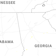
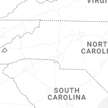
North Carolina
| Local Time | Report Details |
|---|---|
| 4:55 PM EDT | Trees down near the intersection of reedy fork parkway and eckerson roa in guilford county NC, 65.4 miles WNW of Raleigh, NC |
| 8:38 PM EDT | Tree down near the intersection of haystack road and thurmond roa in surry county NC, 73.4 miles E of Bristol, TN |
| 9:07 PM EDT | One tree down on s andy griffith pkwy near rockford s in surry county NC, 66 miles SW of Roanoke, VA |
| 9:19 PM EDT | Tree down across road near intersection of old us 52 s and farm w in surry county NC, 66.9 miles SSW of Roanoke, VA |
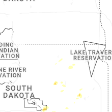
South Dakota
| Local Time | Report Details |
|---|---|
| 4:03 PM CDT | Quarter sized hail reported near Colome, SD, 47.7 miles NE of Valentine, NE |
| 4:09 PM CDT | Ping Pong Ball sized hail reported near Winner, SD, 31.4 miles NE of Valentine, NE |
| 4:35 PM CDT | Quarter sized hail reported near Pukwana, SD, 63.3 miles ESE of Pierre, SD, in addition to a few quarter sized hail stones... rainfall was about 0.30 to 0.40 inch. |
| 4:38 PM CDT | Quarter sized hail reported near Winner, SD, 42.1 miles ENE of Valentine, NE |
| 4:42 PM CDT | Mesonet station 283 sd rwis dixo in gregory county SD, 66.5 miles ENE of Valentine, NE |
| 5:01 PM CDT | Half Dollar sized hail reported near Gregory, SD, 61.1 miles ENE of Valentine, NE, in addition to hail up to half dollar size... heavy rain and 40-50 mph wind gusts stripped some leaves from trees. |
| 5:17 PM CDT | Personal weather statio in gregory county SD, 55.9 miles NNW of Oneill, NE |
| 5:32 PM CDT | Personal weather statio in charles mix county SD, 60.7 miles NNW of Oneill, NE |
| 5:46 PM CDT | Mesonet station rlas2 lake andes raw in charles mix county SD, 55.7 miles N of Oneill, NE |
| 5:55 PM CDT | Storm damage reported in gregory county SD, 45.6 miles NNW of Oneill, NE |
| 6:05 PM CDT | Personal weather statio in charles mix county SD, 50.8 miles N of Oneill, NE |
| 6:08 PM CDT | Quarter sized hail reported near De Smet, SD, 73.5 miles NW of Sioux Falls, SD |
| 6:08 PM CDT | Mesonet station 244 sd rwis ft. randall da in gregory county SD, 41.1 miles N of Oneill, NE |
| 6:20 PM CDT | Mesonet station 304 sd rwis corsic in douglas county SD, 64.8 miles N of Oneill, NE |
| 6:20 PM CDT | Personal weather statio in douglas county SD, 60.5 miles N of Oneill, NE |
| 6:25 PM CDT | Personal weather statio in douglas county SD, 61.4 miles NNE of Oneill, NE |
| 6:25 PM CDT | Mesonet station 304 sd rwis corsic in douglas county SD, 64.8 miles N of Oneill, NE |
| 6:25 PM CDT | Personal weather statio in douglas county SD, 63.6 miles NNE of Oneill, NE |
| 6:28 PM CDT | Personal weather statio in charles mix county SD, 46.9 miles NNE of Oneill, NE |
| 7:06 PM CDT | Personal weather statio in davison county SD, 68.6 miles W of Sioux Falls, SD |
| 7:07 PM CDT | Strong wind gusts pushed through town... breaking many tree branches... blowing out a grain bin... and registering about 53 mph at the airpor in hutchinson county SD, 64.2 miles W of Sioux Falls, SD |
| 7:25 PM CDT | Mesonet station 297 sd rwis howar in miner county SD, 52 miles NW of Sioux Falls, SD |
| 7:36 PM CDT | Measured by personal weather station. first severe gust at 736 pm at 61 mph... and 66 mph at 741 p in yankton county SD, 59.8 miles SW of Sioux Falls, SD |
| 7:38 PM CDT | Tree down blocking the road near 3rd and cherry. via social medi in hutchinson county SD, 37.6 miles WSW of Sioux Falls, SD |
| 7:42 PM CDT | Mesonet station 163 sd rwis freeman. initial severe gust at 742 pm with a peak gust of 61 mph at 744 p in hutchinson county SD, 39.2 miles WSW of Sioux Falls, SD |
| 8:22 PM CDT | Mesonet station 18 sd rwis montros in mccook county SD, 22.7 miles WNW of Sioux Falls, SD |
| 8:35 PM CDT | Wind gusts estimated at 60-65 mph knocked a couple trees down. heavy rain followed... reducing visibility to about 100 feet in minnehaha county SD, 12.4 miles WNW of Sioux Falls, SD |
| 8:45 PM CDT | Via personal weather statio in lake county SD, 28.5 miles NNW of Sioux Falls, SD |
| 8:48 PM CDT | Personal weather statio in minnehaha county SD, 4.8 miles NW of Sioux Falls, SD |
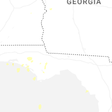
Georgia
| Local Time | Report Details |
|---|---|
| 5:15 PM EDT | Em reports a few trees down and power out along hollondville rd just north of the intersection with reidsboro r in pike county GA, 43.3 miles S of Atlanta, GA |
| 6:24 PM EDT | Multiple trees and power lines reported down... blocking the road on scout island rd near jackson lak in butts county GA, 43 miles SE of Atlanta, GA |
| 6:30 PM EDT | Tree reported down through the roof of a home on harper s in butts county GA, 40.9 miles SE of Atlanta, GA |
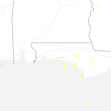
Florida
| Local Time | Report Details |
|---|---|
| 4:25 PM CDT | Washington county reports trees down in the area of clayton r in washington county FL, 47.9 miles ENE of Miramar Beach, FL |
| 4:43 PM CDT | Quarter sized hail reported near Chipley, FL, 42.7 miles ENE of Miramar Beach, FL, social media report of quarter size hail in the greenhead area. |
| 5:56 PM CDT | Tree down on a power line impacting 780 customer in holmes county FL, 42.1 miles NNE of Miramar Beach, FL |
Alabama
| Local Time | Report Details |
|---|---|
| 4:39 PM CDT | Dale county 911 reports a power line down near hwy 27 and county rd 3 in dale county AL, 79.5 miles S of Auburn, AL |
| 5:09 PM CDT | Tree down on power line in the highland park are in geneva county AL, 64.5 miles NE of Miramar Beach, FL |
| 5:16 PM CDT | Social media photo of power lines down in the oak grove area from the wiregrass electric cooperativ in geneva county AL, 60.2 miles NE of Miramar Beach, FL |
| 5:24 PM CDT | Social media report of a tree down at the corner of twin rivers and mcdougald street in eunol in geneva county AL, 55.3 miles NE of Miramar Beach, FL |
| 5:26 PM CDT | Geneva county 911 reports numerous trees and power lines down across genev in geneva county AL, 54 miles NNE of Miramar Beach, FL |
| 5:30 PM CDT | Social media report of trees down on westmont stree in geneva county AL, 53.3 miles NE of Miramar Beach, FL |
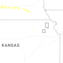
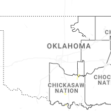
Oklahoma
| Local Time | Report Details |
|---|---|
| 7:20 PM CDT | Burneyville mesone in love county OK, 70.8 miles E of Wichita Falls, TX |
| 9:28 PM CDT | Quarter sized hail reported near Ada, OK, 49 miles NW of Atoka, OK, report from mping: quarter (1.00 in.). |
Kansas
| Local Time | Report Details |
|---|---|
| 1:18 AM CDT | Kcn in cloud county KS, 63.7 miles WNW of Manhattan, KS |
Connect with Interactive Hail Maps