

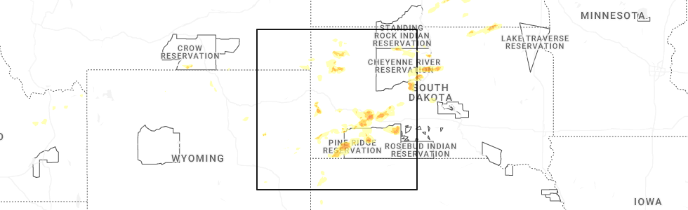
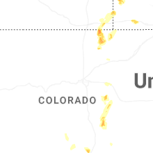
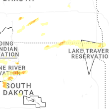
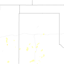
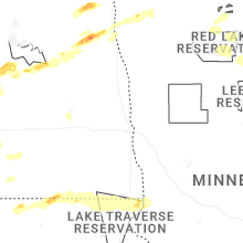
Hail Map for Monday, July 14, 2025
Number of Impacted Households on 7/14/2025
0
Impacted by 1" or Larger Hail
0
Impacted by 1.75" or Larger Hail
0
Impacted by 2.5" or Larger Hail
Square Miles of Populated Area Impacted on 7/14/2025
0
Impacted by 1" or Larger Hail
0
Impacted by 1.75" or Larger Hail
0
Impacted by 2.5" or Larger Hail
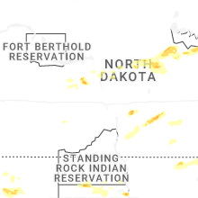
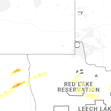
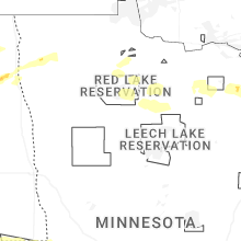
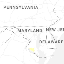
Cities Most Affected by Hail Storms of 7/14/2025
| Hail Size | Demographics of Zip Codes Affected | ||||||
|---|---|---|---|---|---|---|---|
| City | Count | Average | Largest | Pop Density | House Value | Income | Age |
| Inkster, ND | 1 | 2.00 | 2.00 | 2 | $36k | $26.4k | 49.2 |
| Forest River, ND | 1 | 1.75 | 1.75 | 4 | $39k | $32.3k | 45.6 |
Hail and Wind Damage Spotted on 7/14/2025
Filter by Report Type:Hail ReportsWind Reports
States Impacted
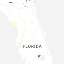
Florida, Georgia, New York, New Hampshire, Wyoming, Mississippi, Maine, Pennsylvania, Colorado, Idaho, South Carolina, Virginia, South Dakota, Texas, Maryland, New Mexico, Nebraska, Montana, North DakotaFlorida
| Local Time | Report Details |
|---|---|
| 2:44 PM EDT | Personnel weather station reynolds park - kflgreen22 reported wind gust of 63 mp in clay county FL, 23.5 miles S of Jacksonville, FL |
| 2:45 PM EDT | A video was relayed of a tree down on powerlines along leonard c taylor pkwy. time was estimated by radar. nearby gust of 63 mph was measured by a personal weather stat in clay county FL, 24.2 miles S of Jacksonville, FL |
| 3:28 PM EDT | Trees and powerlines reported down in the town of florahome. time of event based on radar dat in putnam county FL, 43.5 miles SSW of Jacksonville, FL |
| 4:06 PM EDT | Storm chaser relayed photo and video on social media showing trees down along us-441. time est. off radar and max wind gust of 36 mph at kgnv at 4:07p in alachua county FL, 59.5 miles SW of Jacksonville, FL |
| 4:41 PM EDT | Ochlockonee bay ambient station gusted to 60 mp in wakulla county FL, 32.2 miles SSW of Tallahassee, FL |
| 5:24 PM EDT | Dot traffic cameras show that trees have fallen onto southbound lanes of i-75 at exit 293. time estimated from rada in pasco county FL, 56.1 miles W of Orlando, FL |
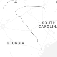
Georgia
| Local Time | Report Details |
|---|---|
| 3:30 PM EDT | Trees down on highway 121 between brannen road and pond view road. time estimated by rada in candler county GA, 62.2 miles WNW of Savannah, GA |
| 6:06 PM EDT | Social media reports a tree down along ceasar avenue. time estimated by radar. at the same time... the power was out at darwelong roa in long county GA, 46.3 miles SW of Savannah, GA |
New York
| Local Time | Report Details |
|---|---|
| 3:35 PM EDT | Trees down blocking right lane of i 87 northbound. time estimated by rada in rockland county NY, 28.2 miles N of Brooklyn, NY |
New Hampshire
| Local Time | Report Details |
|---|---|
| 3:35 PM EDT | Stratford hollow fire dept employee reported 4 downed trees and numerous large branches along the daniel webster hwy between mt view rd and percy rd; 1 tree was partial in coos county NH, 82.2 miles E of Burlington, VT |
| 6:41 PM EDT | Multiple reports of trees and wires down on north side of newfound lake. numerous reports of power outages (residential and commercial in grafton county NH, 76.4 miles W of Portland, ME |
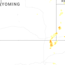
Wyoming
| Local Time | Report Details |
|---|---|
| 2:15 PM MDT | Storm damage reported in laramie county WY, 26.4 miles E of Laramie, WY |
Mississippi
| Local Time | Report Details |
|---|---|
| 3:15 PM CDT | Trees were blown down on sylvarena roa in copiah county MS, 42.6 miles SSW of Jackson, MS |
Maine
| Local Time | Report Details |
|---|---|
| 4:19 PM EDT | Tree down across the roa in aroostook county ME, 25.2 miles SW of Caribou, ME |
| 4:19 PM EDT | Quarter sized hail reported near Ashland, ME, 24.3 miles SW of Caribou, ME, quarter size hail in ashland. |
| 4:25 PM EDT | Large tree uproote in aroostook county ME, 24.3 miles SW of Caribou, ME |
| 4:26 PM EDT | Corrects timing of previous tstm wnd dmg report from 1 ese ashland. trees down and pole snapped near ashland high school closing roa in aroostook county ME, 24.3 miles SW of Caribou, ME |
| 4:49 PM EDT | Trees down and pole snapped near ashland high school closing roa in aroostook county ME, 24.3 miles SW of Caribou, ME |
Pennsylvania
| Local Time | Report Details |
|---|---|
| 5:12 PM EDT | Tree down blocking the road at oriole l in york county PA, 53.2 miles NNW of Baltimore, MD |
| 5:12 PM EDT | Power lines dow in york county PA, 52.6 miles NNW of Baltimore, MD |
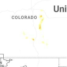
Colorado
| Local Time | Report Details |
|---|---|
| 3:15 PM MDT | Storm damage reported in arapahoe county CO, 27.2 miles ESE of Denver, CO |
| 4:05 PM MDT | Quarter sized hail reported near Kiowa, CO, 45.3 miles SE of Denver, CO |
| 4:10 PM MDT | Corrects previous tstm wnd gst report from 2 ese kiow in arapahoe county CO, 42.8 miles E of Denver, CO |
| 4:10 PM MDT | Storm damage reported in elbert county CO, 41.2 miles SE of Denver, CO |
Idaho
| Local Time | Report Details |
|---|---|
| 3:30 PM MDT | Mesonet station pc374 reno gulc in clark county ID, 51.3 miles NW of Idaho Falls, ID |
| 3:30 PM MDT | Pacificorp reno gulc in jefferson county ID, 45.7 miles NW of Idaho Falls, ID |
| 4:10 PM MDT | Mesonet station bas base of howe pea in butte county ID, 50.3 miles WNW of Idaho Falls, ID |
| 4:15 PM MDT | Mesonet station itdd3 d6 junction summit id-22/id-3 in butte county ID, 45.6 miles WNW of Idaho Falls, ID |
South Carolina
| Local Time | Report Details |
|---|---|
| 5:37 PM EDT | Bamberg county dispatch reported trees down on a powerline in denmark... sc. time estimated by rada in bamberg county SC, 49 miles ESE of Augusta, GA |
Virginia
| Local Time | Report Details |
|---|---|
| 6:08 PM EDT | Tree downed by thunderstorm winds at the intersection of howardsville road and mulberry grove roa in buckingham county VA, 52.4 miles W of Richmond, VA |
| 9:43 PM EDT | Tree downed by thunderstorm winds on the southbound side and blocking the entire lane of virgil h goode highway.... one mile north of fishburn mountain roa in franklin county VA, 27.3 miles S of Roanoke, VA |
| 9:43 PM EDT | Tree down covering part of road near the intersection of windy ridge rd and virgil h goode hw in franklin county VA, 24.6 miles S of Roanoke, VA |
| 10:16 PM EDT | One tree down at old eanes store loo in henry county VA, 36.4 miles SSE of Roanoke, VA |
| 10:16 PM EDT | Tree down at the intersection of chatham road and mountain valley roa in henry county VA, 36.2 miles SSE of Roanoke, VA |
| 10:20 PM EDT | Trees downed on old church rd near tunstal in new kent county VA, 30.9 miles ENE of Richmond, VA |
| 11:34 PM EDT | Vdot reporting exit 52 at bank st is close in city of petersburg county VA, 23.4 miles SE of Richmond, VA |
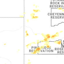
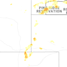
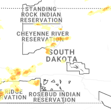
South Dakota
| Local Time | Report Details |
|---|---|
| 4:10 PM MDT | Storm damage reported in pennington county SD, 49.8 miles E of Rapid City, SD |
| 4:20 PM MDT | Storm damage reported in pennington county SD, 49.8 miles E of Rapid City, SD |
| 4:40 PM MDT | Storm damage reported in pennington county SD, 51.3 miles ESE of Rapid City, SD |
| 4:46 PM MDT | Semi blown over on i-90 near mm14 in jackson county SD, 71.3 miles ESE of Rapid City, SD |
| 4:46 PM MDT | Storm damage reported in jackson county SD, 72.3 miles ESE of Rapid City, SD |
| 4:51 PM MDT | Storm damage reported in jackson county SD, 72.3 miles ESE of Rapid City, SD |
| 4:55 PM MDT | Storm damage reported in haakon county SD, 65.9 miles WSW of Pierre, SD |
| 5:20 PM MDT | Storm damage reported in fall river county SD, 68.3 miles S of Rapid City, SD |
| 5:31 PM MDT | Storm damage reported in fall river county SD, 62.6 miles S of Rapid City, SD |
| 5:40 PM MDT | Storm damage reported in jackson county SD, 66.7 miles WSW of Pierre, SD |
| 5:55 PM MDT | Storm damage reported in oglala lakota county SD, 63.3 miles SE of Rapid City, SD |
| 6:26 PM MDT | Storm damage reported in jackson county SD, 49.4 miles SW of Pierre, SD |
| 7:50 PM CDT | Mesonet station onms2 onida 13wsw (sd mesonet in sully county SD, 19.5 miles N of Pierre, SD |
| 8:07 PM CDT | Asos station kpir pierre muni ap. initial gust of 82 mph at asos... which is asos time of peak wind. another gust of 82 mph occurred at 811 pm cd in hughes county SD, 3.6 miles ENE of Pierre, SD |
| 8:11 PM CDT | Asos station kpir pierre muni ap. trained spotter also reports trees down in pierr in hughes county SD, 3.6 miles ENE of Pierre, SD |
| 8:30 PM CDT | Power lines down blocking the road. estimated wind near 100 mp in sully county SD, 24.2 miles NNE of Pierre, SD |
| 7:40 PM MDT | Mesonet station 178 trail city (sddot in corson county SD, 79.3 miles NNW of Pierre, SD |
| 7:45 PM MDT | Mesonet station tims2 timber lake (sd mesonet in dewey county SD, 81.2 miles NNW of Pierre, SD |
| 7:45 PM MDT | Storm damage reported in jackson county SD, 72.3 miles ESE of Rapid City, SD |
| 7:45 PM MDT | Storm damage reported in haakon county SD, 44 miles WSW of Pierre, SD |
| 7:51 PM MDT | Mesonet station 293 timber lake (sddot in dewey county SD, 81.3 miles NNW of Pierre, SD |
| 7:51 PM MDT | Flom weatherlink statio in stanley county SD, 39 miles WSW of Pierre, SD |
| 9:00 PM CDT | Estimates 50-60 mph wind on 180th street 5 miles west of hwy 4 in hyde county SD, 45.1 miles NE of Pierre, SD |
| 8:02 PM MDT | Storm damage reported in haakon county SD, 41.5 miles WSW of Pierre, SD |
| 8:20 PM MDT | Storm damage reported in butte county SD, 68.8 miles N of Rapid City, SD |
| 8:20 PM MDT | Storm damage reported in haakon county SD, 44 miles WSW of Pierre, SD |
| 8:25 PM MDT | Storm damage reported in butte county SD, 68.8 miles N of Rapid City, SD |
| 9:25 PM CDT | Mesonet station 13 vivian (sddot in lyman county SD, 22 miles S of Pierre, SD |
| 8:25 PM MDT | Storm damage reported in haakon county SD, 44 miles WSW of Pierre, SD |
| 8:35 PM MDT | Storm damage reported in butte county SD, 68.8 miles N of Rapid City, SD |
| 8:35 PM MDT | Storm damage reported in haakon county SD, 44 miles WSW of Pierre, SD |
| 8:45 PM MDT | Storm damage reported in haakon county SD, 41.5 miles WSW of Pierre, SD |
| 8:50 PM MDT | Storm damage reported in haakon county SD, 44 miles WSW of Pierre, SD |
| 1:36 AM CDT | Mesonet station 58 victor (sddot in roberts county SD, 66.1 miles S of Fargo, ND |
Texas
| Local Time | Report Details |
|---|---|
| 5:24 PM CDT | Quarter sized hail reported near Ropesville, TX, 22.9 miles WSW of Lubbock, TX, accumulating hail up to a depth of two inches... with quarter size hail measured within the swath. vegetation shredded. |
| 6:10 PM CDT | West texas mesonet repor in lynn county TX, 42.9 miles S of Lubbock, TX |
| 6:14 PM CDT | Public reported power pole leaning after strong winds moved through the area. wooden fence also normal to the wind direction... exhibited no visible damag in lubbock county TX, 5.7 miles S of Lubbock, TX |
Maryland
| Local Time | Report Details |
|---|---|
| 6:32 PM EDT | Large tree branch has fallen on a garage and part of the house connected to it at 2414 blooming way in anne arundel county MD, 17.1 miles SSW of Baltimore, MD |
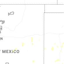
New Mexico
| Local Time | Report Details |
|---|---|
| 6:00 PM MDT | Corrected report. mesonet station nm012 i-25 @ rowe (nmdot in san miguel county NM, 62 miles ENE of Albuquerque, NM |
Nebraska
| Local Time | Report Details |
|---|---|
| 7:54 PM MDT | Corrects previous wnd gst report from 2 ssw sidney. asos station ksny sidney airpor in cheyenne county NE, 63.4 miles SE of Scottsbluff, NE |
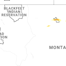
Montana
| Local Time | Report Details |
|---|---|
| 8:00 PM MDT | Mesonet station mtlwm 2.0 sw livingston (mt dot in park county MT, 21.1 miles E of Bozeman, MT |
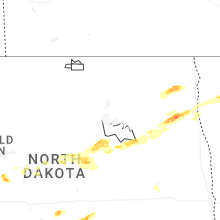
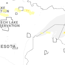
North Dakota
| Local Time | Report Details |
|---|---|
| 10:52 PM CDT | Quarter sized hail reported near Wilton, ND, 36.2 miles N of Bismarck, ND, report from mping: quarter (1.00 in.). |
| 12:05 AM CDT | Half Dollar sized hail reported near Inkster, ND, 56.4 miles E of Devils Lake, ND, in town. |
| 12:08 AM CDT | Hen Egg sized hail reported near Inkster, ND, 56.4 miles E of Devils Lake, ND, in town. |
| 12:24 AM CDT | Golf Ball sized hail reported near Forest River, ND, 65.5 miles E of Devils Lake, ND, relayed via broadcast media. |
| 12:25 AM CDT | Quarter sized hail reported near Minto, ND, 70.5 miles E of Devils Lake, ND |
| 1:05 AM CDT | Half Dollar sized hail reported near Hoople, ND, 63.4 miles ENE of Devils Lake, ND |
Connect with Interactive Hail Maps