

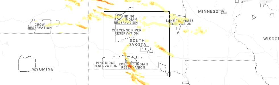
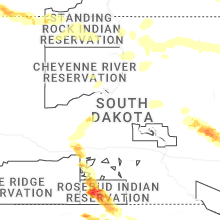
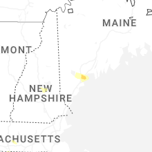
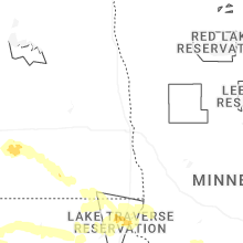
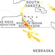
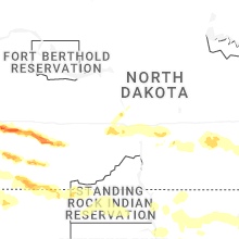
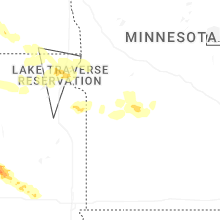
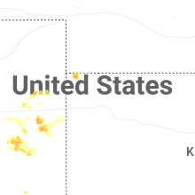
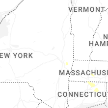
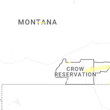
Hail Map for Sunday, July 20, 2025
Number of Impacted Households on 7/20/2025
0
Impacted by 1" or Larger Hail
0
Impacted by 1.75" or Larger Hail
0
Impacted by 2.5" or Larger Hail
Square Miles of Populated Area Impacted on 7/20/2025
0
Impacted by 1" or Larger Hail
0
Impacted by 1.75" or Larger Hail
0
Impacted by 2.5" or Larger Hail

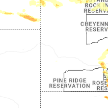
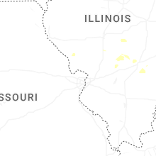

Cities Most Affected by Hail Storms of 7/20/2025
| Hail Size | Demographics of Zip Codes Affected | ||||||
|---|---|---|---|---|---|---|---|
| City | Count | Average | Largest | Pop Density | House Value | Income | Age |
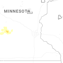
| Rosebud, SD | 2 | 3.63 | 4.50 | 0 | $33k | $19.8k | 22.9 |
| Saint Francis, SD | 2 | 2.25 | 2.50 | 0 | $10k | $19.4k | 22.8 |
| Parmelee, SD | 1 | 4.00 | 4.00 | 0 | $56k | $12.6k | 21.3 |
| Belfield, ND | 2 | 1.75 | 1.75 | 1 | $38k | $28.4k | 45.6 |
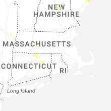
| Gilford, NH | 2 | 1.75 | 1.75 | 236 | $0k | $0.0k | 48.0 |
| Fort Pierre, SD | 1 | 2.50 | 2.50 | 2 | $85k | $41.6k | 41.8 |
| South Heart, ND | 1 | 2.25 | 2.25 | 1 | $64k | $35.1k | 40.5 |
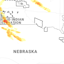
| Cody, NE | 1 | 1.75 | 1.75 | 0 | $34k | $26.7k | 41.3 |
| Lefor, ND | 1 | 1.75 | 1.75 | 1 | $51k | $26.3k | 51.8 |
| Crookston, NE | 1 | 1.75 | 1.75 | 1 | $26k | $27.0k | 46.0 |
| Mott, ND | 1 | 1.75 | 1.75 | 2 | $29k | $28.8k | 51.1 |
| Rhame, ND | 1 | 1.75 | 1.75 | 0 | $31k | $22.9k | 47.0 |
Hail and Wind Damage Spotted on 7/20/2025
Filter by Report Type:Hail ReportsWind Reports
States Impacted
New Hampshire, Maine, New York, South Dakota, Ohio, Georgia, Alabama, Massachusetts, Vermont, Kentucky, West Virginia, Connecticut, Montana, Nebraska, North Dakota, North Carolina, Virginia, Indiana, ColoradoNew Hampshire
| Local Time | Report Details |
|---|---|
| 1:52 PM EDT | Quarter sized hail reported near Conway, NH, 49.7 miles WNW of Portland, ME, reported by amateur radio. |
| 1:55 PM EDT | Quarter sized hail reported near Center Conway, NH, 44.5 miles WNW of Portland, ME |
| 5:00 PM EDT | Tree down on house. fire dept. dispatched. time estimated by rada in merrimack county NH, 76.6 miles W of Portland, ME |
| 5:02 PM EDT | Tree down on interstate 93 northbound... blocking one lane. time estimated by rada in belknap county NH, 68.4 miles W of Portland, ME |
| 5:05 PM EDT | Dispatch reported trees and wires down on a home in franklin. time estimated by rada in merrimack county NH, 72.1 miles WSW of Portland, ME |
| 5:10 PM EDT | Ping Pong Ball sized hail reported near Sanbornton, NH, 67.4 miles W of Portland, ME, reported by amateur radio. |
| 5:10 PM EDT | Ping Pong Ball sized hail reported near Hill, NH, 73.1 miles W of Portland, ME, report of 1.5 in hail shattering car wind shield. |
| 5:10 PM EDT | Spotter reported a large tree down blocking road-intersection of grange st and lancaster hill rd. time est. by rada in belknap county NH, 65.6 miles W of Portland, ME |
| 5:17 PM EDT | Observed trees and branches down on morin rd as well as nh highway 107. time estimated by rada in belknap county NH, 60.8 miles W of Portland, ME |
| 5:20 PM EDT | Half Dollar sized hail reported near Gilmanton, NH, 60.2 miles WSW of Portland, ME, half dollar size hail for about 7-8 minutes. |
| 5:21 PM EDT | Golf Ball sized hail reported near Gilford, NH, 59.1 miles W of Portland, ME, reported by weather spotter. |
| 5:22 PM EDT | Ping Pong Ball sized hail reported near Belmont, NH, 62.4 miles WSW of Portland, ME |
| 5:23 PM EDT | Golf Ball sized hail reported near Gilford, NH, 59.1 miles W of Portland, ME, corrects previous hail report from 4 se laconia. reported by weather spotter. |
| 5:30 PM EDT | Report of a large tree crushing a parked car on sawtooth r in belknap county NH, 58.9 miles WSW of Portland, ME |
| 6:26 PM EDT | Reported by weather spotter. large tree crushed a garage. time estimated by rada in hillsborough county NH, 69.9 miles N of Providence, RI |
| 6:44 PM EDT | Reported by weather spotter. large tree partially blocking musguash road. time estimated by rada in hillsborough county NH, 61.9 miles N of Providence, RI |
Maine
| Local Time | Report Details |
|---|---|
| 2:36 PM EDT | Multiple trees down near hanscom school rd in limington. time estimated by rada in york county ME, 22.8 miles WNW of Portland, ME |
| 2:37 PM EDT | Large pine tree down on hanscomb school rd in limington. time estimated by rada in york county ME, 22.8 miles WNW of Portland, ME |
| 2:38 PM EDT | Spotter sent pictures of large pine tree snapped near base across road and took down wires as well. time estimated by rada in york county ME, 22.8 miles WNW of Portland, ME |
| 2:40 PM EDT | Tree on a house on leisure lane. time estimated by rada in cumberland county ME, 18.5 miles NW of Portland, ME |
| 2:40 PM EDT | Tree down on a house on ridge rd. time estimated by rada in cumberland county ME, 17.7 miles NW of Portland, ME |
| 2:53 PM EDT | Multiple large trees down throughout the area. tree on a house on canal st in gorham. another on mosher rd in gorham where a roof came off a hous in cumberland county ME, 9.2 miles WNW of Portland, ME |
| 2:56 PM EDT | Multiple trees down on houses along route 302 in windham... just in from the westbrook lin in cumberland county ME, 8.1 miles NW of Portland, ME |
| 3:00 PM EDT | Quarter sized hail reported near Falmouth, ME, 7 miles N of Portland, ME, 1 in hail reported. patio umbrella with holes and gazebo roof damaged. time estimated by radar. |
| 3:05 PM EDT | Quarter sized hail reported near Falmouth, ME, 3.5 miles N of Portland, ME, report from mping: quarter (1.00 in.). |
New York
| Local Time | Report Details |
|---|---|
| 2:42 PM EDT | Downed tre in montgomery county NY, 21.4 miles W of Schenectady, NY |
| 2:44 PM EDT | Downed tre in montgomery county NY, 21.3 miles W of Schenectady, NY |
| 3:00 PM EDT | Downed tree and wires in pattersonvill in schenectady county NY, 8.9 miles NW of Schenectady, NY |
| 3:24 PM EDT | Pole and wires down in wood in saratoga county NY, 34.7 miles NNE of Schenectady, NY |
| 4:05 PM EDT | Tree and wires down near new york route 203 and alter alley way in nassa in rensselaer county NY, 26.8 miles SE of Schenectady, NY |
| 4:12 PM EDT | Downed tree across road at route 22 and provost r in rensselaer county NY, 35.1 miles ESE of Schenectady, NY |
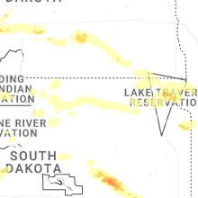
South Dakota
| Local Time | Report Details |
|---|---|
| 2:00 PM CDT | Mesonet station rhus2 danforth 5 e... time estimated from rada in hand county SD, 78.8 miles E of Pierre, SD |
| 2:00 PM CDT | Reported via facebook. 2 inch diameter tree branches down. time estimated from rada in hand county SD, 76.8 miles E of Pierre, SD |
| 2:33 PM CDT | Corrects previous tstm wnd dmg report from 4 nnw lane. reports of a camper blown over as well as several trees blown onto powerlines. report via social medi in jerauld county SD, 92.5 miles S of Aberdeen, SD |
| 2:44 PM CDT | Mesonet station 305 sd rwis lan in jerauld county SD, 93.3 miles WNW of Sioux Falls, SD |
| 2:49 PM CDT | Mesonet station 305 sd rwis lan in jerauld county SD, 93.3 miles WNW of Sioux Falls, SD |
| 3:00 PM CDT | Mesonet station wsms2 woonsocket 4nn in sanborn county SD, 88 miles WNW of Sioux Falls, SD |
| 3:04 PM CDT | Ping Pong Ball sized hail reported near Woonsocket, SD, 84.7 miles WNW of Sioux Falls, SD, relayed report from social media. |
| 3:05 PM CDT | Social media related report of numerous tree and branch damage across the town. sides blown in on an empty grain bin. grain truck tipped over. partial roof damage to sh in sanborn county SD, 85.2 miles WNW of Sioux Falls, SD |
| 3:05 PM CDT | Reports of numerous tree damage across the city of woonsocke in sanborn county SD, 84.7 miles WNW of Sioux Falls, SD |
| 3:05 PM CDT | Quarter sized hail reported near Woonsocket, SD, 84.7 miles WNW of Sioux Falls, SD |
| 3:22 PM CDT | Storm damage reported in sanborn county SD, 74.4 miles WNW of Sioux Falls, SD |
| 3:33 PM CDT | Reports of a camper blown over as well as several trees blown onto powerlines. report via social medi in jerauld county SD, 92.5 miles S of Aberdeen, SD |
| 3:36 PM CDT | Trained spotter estimated between 50-60 mph winds. time estimated via rada in davison county SD, 67.2 miles WNW of Sioux Falls, SD |
| 3:52 PM CDT | A trained weather spotter reported 4 inch tree branches down off a cottonwood tre in miner county SD, 57.8 miles WNW of Sioux Falls, SD |
| 6:40 PM CDT | Quarter sized hail reported near Parmelee, SD, 40.8 miles NW of Valentine, NE |
| 6:45 PM CDT | Grapefruit sized hail reported near Parmelee, SD, 39.2 miles NW of Valentine, NE, most baseball size. |
| 7:04 PM CDT | Tennis Ball sized hail reported near Saint Francis, SD, 30.9 miles NW of Valentine, NE |
| 7:14 PM CDT | Baseball sized hail reported near Rosebud, SD, 28.9 miles NNW of Valentine, NE |
| 7:15 PM CDT | Softball sized hail reported near Rosebud, SD, 29.1 miles NNW of Valentine, NE |
| 7:43 PM CDT | Hen Egg sized hail reported near Saint Francis, SD, 25.9 miles NW of Valentine, NE, most quarter size. been hailing for 15 minutes and still hailing. |
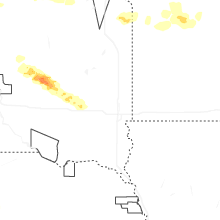
| 6:45 PM MDT | Storm damage reported in bennett county SD, 46.7 miles WNW of Valentine, NE |
| 6:55 PM MDT | Half Dollar sized hail reported near Belvidere, SD, 55.3 miles WSW of Pierre, SD |
| 7:01 PM MDT | Tennis Ball sized hail reported near Fort Pierre, SD, 35.4 miles W of Pierre, SD, estimated 2.5 inch hailstone. mostly quarter size and small. no damage reported. |
| 1:49 AM CDT | Quarter sized hail reported near Bowdle, SD, 56.5 miles W of Aberdeen, SD, public comment on facebook of dime to quarter sized hail along with high winds producing some light damage. time estimated by radar. |
| 2:57 AM CDT | Personal weather station 2 miles ene aberdeen measured 62 mph peak wind gust. exact time estimated by rada in brown county SD, 2.3 miles NE of Aberdeen, SD |
| 3:45 AM CDT | Mesonet station 2 lake city (sddot in marshall county SD, 54.8 miles ENE of Aberdeen, SD |
Ohio
| Local Time | Report Details |
|---|---|
| 3:34 PM EDT | Tree down along macedonia road in eagle township. time estimated from rada in vinton county OH, 47.1 miles SSE of Columbus, OH |
| 3:35 PM EDT | Tree down on diamond brick road. time estimated from rada in athens county OH, 52.2 miles SE of Columbus, OH |
| 3:37 PM EDT | Power line down near pretty run road and garrett ridge road. time estimated from rada in vinton county OH, 49.6 miles SSE of Columbus, OH |
| 4:06 PM EDT | Tree down on power line at fossil rock road and sargent road in guysville. power line was smoking. time estimated from rada in athens county OH, 65.1 miles NNW of Charleston, WV |
| 5:20 PM EDT | Tree down on state route 650 near blocking one lane. time estimated from rada in lawrence county OH, 62 miles WNW of Charleston, WV |
| 5:55 PM EDT | Tree hanging in roadway on state route 77 in lawrence county OH, 41.9 miles WNW of Charleston, WV |
Georgia
| Local Time | Report Details |
|---|---|
| 3:47 PM EDT | Ccso reported a couple trees down and blocking roadways on highway 121 n near hendricks roa in candler county GA, 64.1 miles WNW of Savannah, GA |
| 3:56 PM EDT | Emergency manager reported a tree down at the intersection of metter road and westside roa in bulloch county GA, 58.7 miles WNW of Savannah, GA |
| 4:20 PM EDT | Emergency manager reports tree down at intersection of highway 24 and franklin roa in bulloch county GA, 44.2 miles NW of Savannah, GA |
| 4:25 PM EDT | Emergency manager reports tree and live wires down at intersection of stiles street and south jackson roa in bulloch county GA, 45 miles WNW of Savannah, GA |
| 6:19 PM EDT | Tree down along parks mill road near alford lan in morgan county GA, 64 miles ESE of Atlanta, GA |
| 6:23 PM EDT | Tree and multiple large limbs down in parks ferry campgroun in greene county GA, 66.5 miles ESE of Atlanta, GA |
Alabama
| Local Time | Report Details |
|---|---|
| 3:27 PM CDT | Tree down across cr 86. time estimated from rada in lauderdale county AL, 23.5 miles ENE of Florence, AL |
| 3:33 PM CDT | Tree down blocking south bound lane of roadway. time estimated based on rada in lauderdale county AL, 12.1 miles NE of Florence, AL |
Massachusetts
| Local Time | Report Details |
|---|---|
| 4:39 PM EDT | A couple of trees and a large branch were downed near lee including on prospect street... william parkway and on the massachusetts turnpike westboun in berkshire county MA, 50.2 miles SE of Schenectady, NY |
| 4:45 PM EDT | Tree down on wires blocking road - washington mountain r in berkshire county MA, 51.4 miles SE of Schenectady, NY |
| 5:30 PM EDT | Several trees downs in belchertown near turkey hill road... chauncey walker street... summir street... and shaw road (tree on car in hampshire county MA, 58.8 miles WNW of Providence, RI |
| 7:05 PM EDT | Tree down blocking roa in middlesex county MA, 58.7 miles N of Providence, RI |
| 7:05 PM EDT | Tree and multiple power lines dow in middlesex county MA, 57.3 miles N of Providence, RI |
| 7:12 PM EDT | Tree down near on newton street near route 3 in middlesex county MA, 38.4 miles N of Providence, RI |
| 7:23 PM EDT | Tree down blocking road near linebrook and haverhill roa in essex county MA, 60.9 miles NNE of Providence, RI |
| 7:25 PM EDT | Tree down blocking part of a roa in essex county MA, 59.4 miles NNE of Providence, RI |
| 7:25 PM EDT | Tree and wires dow in essex county MA, 57.2 miles NNE of Providence, RI |
| 7:40 PM EDT | Several trees down across tow in essex county MA, 57.7 miles NNE of Providence, RI |
| 7:42 PM EDT | Tree and wires down. another tree down on two cars on durnell avenu in suffolk county MA, 40.3 miles NNE of Providence, RI |
| 8:00 PM EDT | Tree downed on wires near whiting st in hingham. relayed by amateur radi in plymouth county MA, 36.4 miles NE of Providence, RI |
| 8:03 PM EDT | Tree dow in plymouth county MA, 35 miles NE of Providence, RI |
Vermont
| Local Time | Report Details |
|---|---|
| 5:00 PM EDT | Downed tree on house in saxtons rive in windham county VT, 76 miles ENE of Schenectady, NY |
Kentucky
| Local Time | Report Details |
|---|---|
| 5:21 PM EDT | Tree down blocking state route 7 in load. time estimated from rada in greenup county KY, 73.5 miles WNW of Charleston, WV |
| 7:40 PM EDT | Reports large branch down at circlewood drive. possible tornado. time estimated from rada in kenton county KY, 9.6 miles SSW of Cincinnati, OH |
| 7:42 PM EDT | Tree down on richardson road and madison pike. photo on social medi in kenton county KY, 8.9 miles SSW of Cincinnati, OH |
| 7:44 PM EDT | Branches down on kieffer ridge. photo shared on social medi in kenton county KY, 11 miles S of Cincinnati, OH |
West Virginia
| Local Time | Report Details |
|---|---|
| 5:23 PM EDT | Tree down blocking one lane of camp creek road. time estimated from rada in wayne county WV, 38.8 miles WSW of Charleston, WV |
| 6:25 PM EDT | Tree and lines down blocking jones branch road in jeffrey. time estimated from rada in boone county WV, 28.4 miles SSW of Charleston, WV |
| 6:35 PM EDT | Tree and power lines down. time estimated from rada in boone county WV, 11.9 miles S of Charleston, WV |
| 6:37 PM EDT | Tree down. time estimated from rada in boone county WV, 13.8 miles SSW of Charleston, WV |
| 7:45 PM EDT | Small streams starting to flood in the east lynn area. photos provided... one of which shows part of a garden floodin in wayne county WV, 42.7 miles WSW of Charleston, WV |
Connecticut
| Local Time | Report Details |
|---|---|
| 5:45 PM EDT | 3 trees downed on powerline wires on bushy hill rd in granby. relayed by amateur radi in hartford county CT, 72.8 miles W of Providence, RI |
| 5:50 PM EDT | A few trees down on top of wire in hartford county CT, 60.6 miles W of Providence, RI |
| 6:00 PM EDT | A tree down on wires. another tree down on a hous in hartford county CT, 62.4 miles W of Providence, RI |
| 6:00 PM EDT | Tree downed on a car near pinney rd in somers. no injuries. time estimated by radar. relayed by amateur radi in tolland county CT, 55.8 miles W of Providence, RI |
| 6:05 PM EDT | A tree was downed and a powerline was snapped near ward st in vernon. relayed by amateur radi in tolland county CT, 53.7 miles W of Providence, RI |
| 6:45 PM EDT | Tree downed on wires on pleasant valley rd at mansfield ave in mansfield. relayed by amateur radi in tolland county CT, 42.8 miles W of Providence, RI |
| 6:45 PM EDT | Corrects previous tstm wnd dmg report from 2 wnw willimantic ap. downed powerlines on browns rd in mansfield... with a tree downed on browns rd as well... which was blo in tolland county CT, 42 miles W of Providence, RI |
| 6:55 PM EDT | Tree limbs down causing a power outage reported by eversourc in new london county CT, 46.8 miles WSW of Providence, RI |
| 7:00 PM EDT | Tree branch down on wires on champion road with the road impassabl in new london county CT, 41.4 miles WSW of Providence, RI |
| 7:00 PM EDT | Tree and wires down on ct 8 in new london county CT, 41.9 miles WSW of Providence, RI |
Montana
| Local Time | Report Details |
|---|---|
| 3:48 PM MDT | Storm damage reported in garfield county MT, 61.5 miles SSW of Glasgow, MT |
| 5:50 PM MDT | Asos station kmls miles cit in custer county MT, 2.2 miles NW of Miles City, MT |
| 6:02 PM MDT | Spotter reports their screen door was completely ripped off its hinge in custer county MT, 1.9 miles SSE of Miles City, MT |
| 6:20 PM MDT | Quarter sized hail reported near Terry, MT, 36.9 miles NE of Miles City, MT, lots of rain with hail up to quarter size. |
| 6:20 PM MDT | Big horn county airpor in big horn county MT, 41 miles E of Billings, MT |
| 6:24 PM MDT | Quarter sized hail reported near Terry, MT, 37.2 miles NE of Miles City, MT, report from mping: quarter (1.00 in.). |
| 6:34 PM MDT | Blowing debris caused car damage at campgroun in big horn county MT, 43.3 miles E of Billings, MT |
| 6:45 PM MDT | Ping Pong Ball sized hail reported near Terry, MT, 33.9 miles NE of Miles City, MT, report from mping: ping pong ball (1.50 in.). |
| 7:34 PM MDT | Quarter sized hail reported near Baker, MT, 71.2 miles E of Miles City, MT |
| 8:05 PM MDT | Storm damage reported in fallon county MT, 79.5 miles ESE of Miles City, MT |
| 8:23 PM MDT | Tree damage reported with estimated maximum branch diameter of 5 inche in fallon county MT, 90 miles ESE of Miles City, MT |
| 8:40 PM MDT | Storm damage reported in powder river county MT, 64 miles S of Miles City, MT |
| 8:53 PM MDT | Quarter sized hail reported near Broadus, MT, 63.5 miles SSE of Miles City, MT |
| 8:54 PM MDT | Large tree (cottonwood) fell over in backyar in powder river county MT, 63.5 miles SSE of Miles City, MT |
| 9:00 PM MDT | Mesonet station mtm32 2.4 e broadus (mt-meso in powder river county MT, 70.8 miles SSE of Miles City, MT |
| 9:04 PM MDT | Quarter sized hail reported near Broadus, MT, 68.7 miles SSE of Miles City, MT |
| 9:04 PM MDT | Ping Pong Ball sized hail reported near Broadus, MT, 67.6 miles SSE of Miles City, MT |
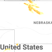
Nebraska
| Local Time | Report Details |
|---|---|
| 4:24 PM MDT | Ping Pong Ball sized hail reported near Nenzel, NE, 28.6 miles W of Valentine, NE, report from mping: ping pong ball (1.50 in.). |
| 4:24 PM MDT | Ping Pong Ball sized hail reported near Nenzel, NE, 28 miles W of Valentine, NE |
| 4:26 PM MDT | Ping Pong Ball sized hail reported near Nenzel, NE, 29.5 miles W of Valentine, NE, report from mping: ping pong ball (1.50 in.). |
| 4:35 PM MDT | Golf Ball sized hail reported near Cody, NE, 28.6 miles WSW of Valentine, NE |
| 4:42 PM MDT | Half Dollar sized hail reported near Nenzel, NE, 29.5 miles W of Valentine, NE, report from mping: half dollar (1.25 in.). |
| 7:45 PM CDT | Updated location. 8 sse of tuthill was the incorrect locatio in todd county SD, 17.8 miles NW of Valentine, NE |
| 7:50 PM CDT | Golf Ball sized hail reported near Crookston, NE, 19.2 miles NW of Valentine, NE |
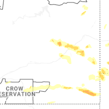
| 8:00 PM CDT | Estimated 60 mph winds... large tree limb in cherry county NE, 12.9 miles NW of Valentine, NE |
| 8:25 PM CDT | Half Dollar sized hail reported near Valentine, NE, 3.9 miles N of Valentine, NE |
| 8:29 PM CDT | Half Dollar sized hail reported near Valentine, NE, 0.3 miles S of Valentine, NE, 60-70 mph winds will the hail. |
| 8:30 PM CDT | Storm damage reported in cherry county NE, 3.5 miles NNW of Valentine, NE |
| 8:33 PM CDT | Quarter sized hail reported near Valentine, NE, 0.3 miles S of Valentine, NE |
| 8:33 PM CDT | Storm damage reported in cherry county NE, 0.3 miles S of Valentine, NE |
| 8:35 PM CDT | Quarter sized hail reported near Valentine, NE, 1 miles S of Valentine, NE, had 1 inch hail and 54 mph wind gust on his home weather station. |
| 8:53 PM CDT | Quarter sized hail reported near Wood Lake, NE, 18.7 miles SE of Valentine, NE |
North Dakota
| Local Time | Report Details |
|---|---|
| 4:45 PM MDT | Storm damage reported in billings county ND, 97.9 miles S of Williston, ND |
| 4:48 PM MDT | Hen Egg sized hail reported near South Heart, ND, 96.6 miles SSE of Williston, ND, hail lasted until 6:05 pm. broken windows and hail covered much of the ground. |
| 4:52 PM MDT | Golf Ball sized hail reported near Belfield, ND, 97.2 miles SSE of Williston, ND, hail ongoing at the time of the call. ground is white with hail. |
| 5:30 PM MDT | Golf Ball sized hail reported near Belfield, ND, 97.2 miles SSE of Williston, ND, heavy rain and widespread hail covering the ground and several vehicles in ditches. hail ranged from dime to golf ball size. |
| 5:55 PM MDT | Golf Ball sized hail reported near Lefor, ND, 88.5 miles W of Bismarck, ND, hail for about 10 to 15 minutes. |
| 6:15 PM MDT | Golf Ball sized hail reported near Mott, ND, 82.3 miles W of Bismarck, ND, heavy rain and estimated wind gusts to 50 mph. hail lasted for about 20 minutes. |
| 6:42 PM MDT | Severe thunderstorm winds were accompanied by large hail. see related hail lsr for more informatio in golden valley county ND, 96.3 miles S of Williston, ND |
| 6:42 PM MDT | Ping Pong Ball sized hail reported near Sentinel Butte, ND, 96.3 miles S of Williston, ND, 60 mph winds accompanied the large hail. wind driven large hail resulted in 3 broken windows and damage to siding. heavy rain also occurred... 1 - 1.5 inches in 20 minu |
| 7:00 PM MDT | Quarter sized hail reported near Scranton, ND, 114.3 miles WSW of Bismarck, ND, hail started around 8 pm and was ongoing at the time of the call around 815 pm. |
| 9:00 PM CDT | Quarter sized hail reported near Mandan, ND, 5.5 miles WNW of Bismarck, ND, facebook post. |
| 8:18 PM MDT | Golf Ball sized hail reported near Rhame, ND, 108.8 miles E of Miles City, MT, relayed through bowman county emergency manager. ongoing at time of call. |
| 8:22 PM MDT | Spotter estimated winds of 60 mph and half dollar sized hai in bowman county ND, 107.8 miles E of Miles City, MT |
| 8:38 PM MDT | Many vehicles hydroplaning south of bowman on hwy 8 in bowman county ND, 118.2 miles E of Miles City, MT |
North Carolina
| Local Time | Report Details |
|---|---|
| 7:43 PM EDT | Massive oak tree down across robin roa in surry county NC, 64 miles SW of Roanoke, VA |
| 9:05 PM EDT | Tree down along glenwood stree in forsyth county NC, 69.5 miles NNE of Charlotte, NC |
| 9:09 PM EDT | A couple trees and a power line down along pacific driv in forsyth county NC, 73.7 miles NNE of Charlotte, NC |
| 10:00 PM EDT | Tree and power line down along cypress park roa in guilford county NC, 69.2 miles WNW of Raleigh, NC |
| 10:00 PM EDT | Tree and power line down near the intersection of south holden road and west vandalia roa in guilford county NC, 69.6 miles WNW of Raleigh, NC |
Virginia
| Local Time | Report Details |
|---|---|
| 8:18 PM EDT | Tree down blocking allison gap roa in smyth county VA, 33.7 miles NE of Bristol, TN |
| 8:33 PM EDT | Tree down blocking part of wassona circl in smyth county VA, 43.8 miles ENE of Bristol, TN |
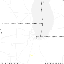
Indiana
| Local Time | Report Details |
|---|---|
| 8:55 PM EDT | Trees dow in daviess county IN, 72.6 miles NNE of Evansville, IN |
Colorado
| Local Time | Report Details |
|---|---|
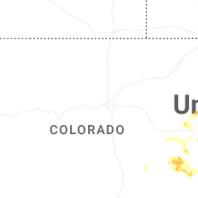
| 11:16 PM MDT | Site kemp well service measured 62 mph wind gus in cheyenne county CO, 79.7 miles WSW of Colby, KS |
Connect with Interactive Hail Maps