

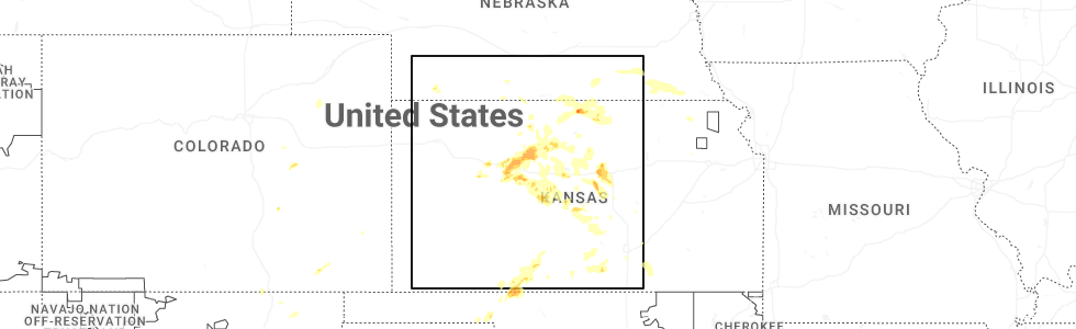
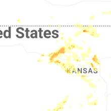
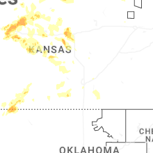
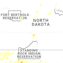
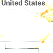
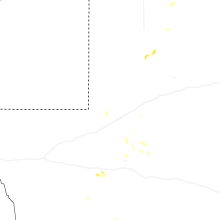
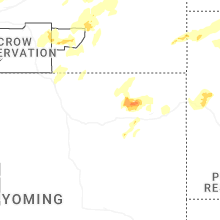
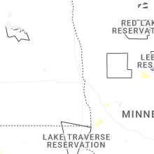
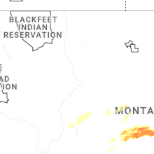
Hail Map for Monday, July 21, 2025
Number of Impacted Households on 7/21/2025
0
Impacted by 1" or Larger Hail
0
Impacted by 1.75" or Larger Hail
0
Impacted by 2.5" or Larger Hail
Square Miles of Populated Area Impacted on 7/21/2025
0
Impacted by 1" or Larger Hail
0
Impacted by 1.75" or Larger Hail
0
Impacted by 2.5" or Larger Hail
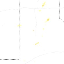
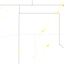
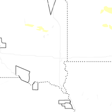
Cities Most Affected by Hail Storms of 7/21/2025
| Hail Size | Demographics of Zip Codes Affected | ||||||
|---|---|---|---|---|---|---|---|
| City | Count | Average | Largest | Pop Density | House Value | Income | Age |
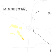
| Madison Lake, MN | 2 | 2.00 | 2.00 | 59 | $138k | $52.6k | 43.4 |
| Plainville, KS | 2 | 1.75 | 1.75 | 8 | $43k | $30.7k | 42.6 |
| Shawmut, MT | 1 | 2.00 | 2.00 | 0 | $48k | $33.3k | 52.4 |
| Two Dot, MT | 1 | 1.75 | 1.75 | 0 | $75k | $25.6k | 53.3 |
| Lavina, MT | 1 | 1.75 | 1.75 | 1 | $45k | $26.4k | 48.0 |
| Saint Peter, MN | 1 | 1.75 | 1.75 | 91 | $112k | $43.4k | 29.9 |
| Mankato, KS | 1 | 1.75 | 1.75 | 5 | $32k | $30.9k | 53.1 |
Hail and Wind Damage Spotted on 7/21/2025
Filter by Report Type:Hail ReportsWind Reports
States Impacted
Minnesota, West Virginia, Kentucky, Texas, Kansas, Georgia, Wyoming, Oklahoma, Utah, Tennessee, New Mexico, Montana, South Dakota, Alabama, North DakotaMinnesota
| Local Time | Report Details |
|---|---|
| 1:20 PM CDT | Many 3 to 4 inch branches down... and one tree dow in sibley county MN, 51.3 miles WSW of Minneapolis, MN |
| 1:50 PM CDT | Golf Ball sized hail reported near Saint Peter, MN, 53 miles SW of Minneapolis, MN, quarter to golfball size hail. |
| 1:58 PM CDT | Quarter sized hail reported near Saint Peter, MN, 55 miles SW of Minneapolis, MN, quarter sized hail near the kwik trip in st peter. |
| 2:15 PM CDT | Quarter sized hail reported near Madison Lake, MN, 57.7 miles SSW of Minneapolis, MN |
| 2:15 PM CDT | Hen Egg sized hail reported near Madison Lake, MN, 57.7 miles SSW of Minneapolis, MN, corrects previous hail report from 5 ssw cleveland. time estimated via radar. |
| 2:52 PM CDT | Hen Egg sized hail reported near Madison Lake, MN, 57.7 miles SSW of Minneapolis, MN, time estimated via radar. |
West Virginia
| Local Time | Report Details |
|---|---|
| 2:58 PM EDT | Tree fell on power lines in wilcoe... lines smoking. time estimated from rada in mcdowell county WV, 66.3 miles NE of Bristol, TN |
Kentucky
| Local Time | Report Details |
|---|---|
| 3:12 PM CDT | Multiple large trees down near intersection of brooklyn chapel and tarvin embry road in butler county KY, 66.5 miles SW of Louisville, KY |
Texas
| Local Time | Report Details |
|---|---|
| 3:25 PM CDT | Thunderstorm winds did damage to a barn roof... with part of the roof removed and hanging off the sid in carson county TX, 43.7 miles ENE of Amarillo, TX |
| 7:10 PM CDT | Storm damage reported in crane county TX, 30.3 miles S of Odessa, TX |
| 10:48 PM CDT | Storm damage reported in swisher county TX, 42.8 miles SSE of Amarillo, TX |
| 12:09 AM CDT | West texas mesone in lubbock county TX, 12.1 miles NNW of Lubbock, TX |
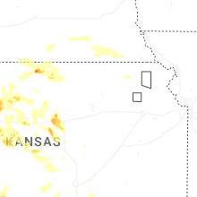
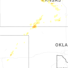
Kansas
| Local Time | Report Details |
|---|---|
| 3:40 PM CDT | Golf Ball sized hail reported near Plainville, KS, 25.6 miles NNE of Hays, KS, trained spotter reports golf ball sized hail east of plainville. |
| 3:46 PM CDT | Quarter sized hail reported near Plainville, KS, 25.6 miles NNE of Hays, KS, spotter reports penny to quarter sized hail and 50-60mph wind gusts east of plainville. |
| 3:56 PM CDT | Quarter sized hail reported near Plainville, KS, 26.5 miles N of Hays, KS, sheriff department reports quarter sized hail northeast of plainville. |
| 4:01 PM CDT | Golf Ball sized hail reported near Plainville, KS, 25.5 miles N of Hays, KS, sheriff department reports golf ball sized hail on the northwest side of plainville. |
| 4:24 PM CDT | Golf Ball sized hail reported near Mankato, KS, 76.9 miles S of Grand Island, NE |
| 4:26 PM CDT | Ping Pong Ball sized hail reported near Burr Oak, KS, 72.8 miles S of Grand Island, NE |
| 4:53 PM CDT | Personal weather station reports gust to 68mp in osborne county KS, 34 miles NNE of Hays, KS |
| 5:24 PM CDT | Quarter sized hail reported near Wakeeney, KS, 31.5 miles WNW of Hays, KS |
| 5:42 PM CDT | Emergency management report tree damage just north of protectio in comanche county KS, 53 miles N of Woodward, OK |
| 6:21 PM CDT | Ambient wind measuring station reported 78 mph gust in comanche county KS, 57.8 miles N of Woodward, OK |
| 6:26 PM CDT | Quarter sized hail reported near Collyer, KS, 42.1 miles WNW of Hays, KS |
| 6:29 PM CDT | Downed powerlines on highway 160 going from the kdot building to about 1.6 miles eas in comanche county KS, 58.6 miles N of Woodward, OK |
| 6:36 PM CDT | Trained spotter estimated winds of 65 to 70 mph and a large tree limb was knocked dow in lincoln county KS, 72.4 miles ENE of Hays, KS |
| 6:44 PM CDT | Storm damage reported in ottawa county KS, 71.7 miles W of Manhattan, KS |
| 7:00 PM CDT | Social media report of broken windows... downed trees... and downed power pole in comanche county KS, 57.8 miles N of Woodward, OK |
| 7:13 PM CDT | A mesonet station reported 65 mph gust in ellis county KS, 14.4 miles NNW of Hays, KS |
| 7:22 PM CDT | Reported a 75mph wind gust on i-70 south of westfal in lincoln county KS, 71.3 miles E of Hays, KS |
| 7:31 PM CDT | Storm damage reported in ellsworth county KS, 67.6 miles E of Hays, KS |
| 7:35 PM CDT | Storm damage reported in ellsworth county KS, 60.1 miles E of Hays, KS |
| 7:40 PM CDT | Storm damage reported in russell county KS, 27.6 miles E of Hays, KS |
| 7:45 PM CDT | Storm damage reported in ellsworth county KS, 75.1 miles E of Hays, KS |
| 7:54 PM CDT | Reported a semi blown over at mile marker 222 on i-70 from thunderstorm wind gust in ellsworth county KS, 63.2 miles E of Hays, KS |
| 7:58 PM CDT | Storm damage reported in ellsworth county KS, 70.4 miles E of Hays, KS |
| 8:02 PM CDT | Storm damage reported in ellis county KS, 18 miles SE of Hays, KS |
| 8:15 PM CDT | Storm damage reported in rush county KS, 15.3 miles S of Hays, KS |
| 8:47 PM CDT | Also reported power poles and large tree limbs dow in barton county KS, 46.2 miles SE of Hays, KS |
| 8:48 PM CDT | Reports of several downed power lines and a transformer also dow in barton county KS, 45.3 miles SE of Hays, KS |
| 8:50 PM CDT | Storm damage reported in barton county KS, 38.4 miles SE of Hays, KS |
| 8:55 PM CDT | Nickel hail was also reporte in barton county KS, 53.8 miles SE of Hays, KS |
| 9:14 PM CDT | Measured on a personal weather statio in mcpherson county KS, 60.1 miles NNW of Wichita, KS |
| 9:21 PM CDT | Storm damage reported in pawnee county KS, 51.7 miles S of Hays, KS |
| 9:31 PM CDT | Storm damage reported in stafford county KS, 69.6 miles W of Wichita, KS |
| 9:32 PM CDT | Measured on a personal weather statio in kingman county KS, 33.2 miles W of Wichita, KS |
| 9:47 PM CDT | Storm damage reported in pratt county KS, 76.6 miles W of Wichita, KS |
| 9:47 PM CDT | Report received from an awn weather statio in pratt county KS, 76.6 miles W of Wichita, KS |
| 9:53 PM CDT | Quarter sized hail reported near Harper, KS, 36.2 miles SW of Wichita, KS, nickel to quarter sized hail. |
| 10:07 PM CDT | Measured on a personal weather statio in sedgwick county KS, 19.4 miles WNW of Wichita, KS |
| 10:16 PM CDT | Multiple 3 inch diameter limbs were snappe in sedgwick county KS, 2.6 miles WNW of Wichita, KS |
| 10:19 PM CDT | Measured on a handheld anemomete in sedgwick county KS, 5.9 miles WNW of Wichita, KS |
| 10:25 PM CDT | The caller also noted a few transformers had blow in sedgwick county KS, 3.2 miles ENE of Wichita, KS |
| 10:32 PM CDT | Measured with a personal weather statio in sedgwick county KS, 9.5 miles SSE of Wichita, KS |
| 10:55 PM CDT | Storm damage reported in marion county KS, 46.3 miles N of Wichita, KS |
| 11:00 PM CDT | Quarter sized hail reported near Haysville, KS, 8.1 miles S of Wichita, KS |
| 11:12 PM CDT | 8 to 10 inch tree limbs reported down as wel in marion county KS, 37 miles NE of Wichita, KS |
Georgia
| Local Time | Report Details |
|---|---|
| 4:50 PM EDT | Coffee county emergency management reports downed trees and powerlines in the vicinity of pridgen and broxton. time of damage based on radar dat in coffee county GA, 12.7 miles NNW of Douglas, GA |
Wyoming
| Local Time | Report Details |
|---|---|
| 3:39 PM MDT | Half Dollar sized hail reported near Rozet, WY, 19.2 miles NE of Gillette, WY |
| 3:39 PM MDT | Storm damage reported in campbell county WY, 19.2 miles NE of Gillette, WY |
| 3:45 PM MDT | Half Dollar sized hail reported near Rozet, WY, 19.2 miles NE of Gillette, WY, broken windshield on truck... damage to siding... several branches 2 inches to 6 inches in diameter down. |
| 3:45 PM MDT | Broken windshield on truck... damage to siding... several branches 2 inches to 6 inches in diameter dow in campbell county WY, 19.2 miles NE of Gillette, WY |
Oklahoma
| Local Time | Report Details |
|---|---|
| 4:55 PM CDT | Mesonet measured a gust to 60 mph at 1655cdt... then measured a gust to 71 mph at 1710cd in beaver county OK, 49.3 miles WNW of Woodward, OK |
| 5:15 PM CDT | Third of three severe wind gust in beaver county OK, 49.3 miles WNW of Woodward, OK |
Utah
| Local Time | Report Details |
|---|---|
| 4:00 PM MDT | Mesonet station dpg17 interstate 8 in tooele county UT, 83 miles W of Salt Lake City, UT |
| 4:20 PM MDT | Mesonet station utkno i-80 at mp 40 knoll in tooele county UT, 73.1 miles W of Salt Lake City, UT |
| 5:30 PM MDT | Mesonet station utwdk sr-177 at mp 5 kaysvill in davis county UT, 17.7 miles NNW of Salt Lake City, UT |
| 6:00 PM MDT | Mesonet station dpg24 w of wildca in tooele county UT, 85.9 miles WSW of Salt Lake City, UT |
| 6:30 PM MDT | Mesonet station utlak sr-68 at mp 15 mosid in utah county UT, 40 miles S of Salt Lake City, UT |
| 7:50 PM MDT | Mesonet station freut fremont island - miller hil in weber county UT, 35.5 miles NW of Salt Lake City, UT |
| 8:09 PM MDT | Asos station klgu logan-cache airpor in cache county UT, 70.5 miles N of Salt Lake City, UT |
| 8:37 PM MDT | Awos station kbmc brigham city rgnl airpor in box elder county UT, 55.4 miles N of Salt Lake City, UT |
| 8:50 PM MDT | Mesonet station utnbc i-15 north brigham cit in box elder county UT, 57.4 miles N of Salt Lake City, UT |
| 9:03 PM MDT | Mesonet station ucl04 crow mountai in cache county UT, 76.7 miles N of Salt Lake City, UT |
| 10:10 PM MDT | Mesonet station pc124 crow mountai in cache county UT, 76.7 miles N of Salt Lake City, UT |
Tennessee
| Local Time | Report Details |
|---|---|
| 5:15 PM CDT | A tree was blown down along new york av in davidson county TN, 4.6 miles W of Nashville, TN |
| 5:25 PM CDT | Numerous branches were blown down in the crieve hall are in davidson county TN, 7.5 miles S of Nashville, TN |
| 5:30 PM CDT | A downed tree was blocking randall driv in davidson county TN, 6.9 miles SSE of Nashville, TN |
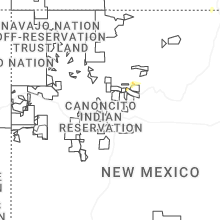
New Mexico
| Local Time | Report Details |
|---|---|
| 4:16 PM MDT | Quarter sized hail reported near Springer, NM, 74.2 miles E of Taos, NM, coop observer reports hail up to quarter size. |
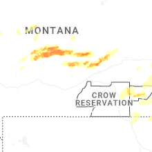
Montana
| Local Time | Report Details |
|---|---|
| 4:55 PM MDT | Golf Ball sized hail reported near Two Dot, MT, 69.2 miles NE of Bozeman, MT |
| 5:00 PM MDT | Storm damage reported in rosebud county MT, 60.1 miles SSW of Miles City, MT |
| 5:50 PM MDT | Quarter sized hail reported near Shawmut, MT, 66.3 miles NW of Billings, MT |
| 6:00 PM MDT | Mesonet station mtswc 5.2 w hathaway (mt dot in rosebud county MT, 24 miles WSW of Miles City, MT |
| 8:16 PM MDT | Hen Egg sized hail reported near Shawmut, MT, 62.5 miles NW of Billings, MT |
| 9:00 PM MDT | Golf Ball sized hail reported near Lavina, MT, 51.4 miles NNW of Billings, MT |
| 11:44 PM MDT | Mesonet station kigm8 king coule in valley county MT, 32.6 miles SSW of Glasgow, MT |
| 11:54 PM MDT | Mesonet station ggwfp 2.4 e fort peck (ggwwfo in mccone county MT, 16.8 miles SE of Glasgow, MT |
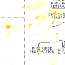
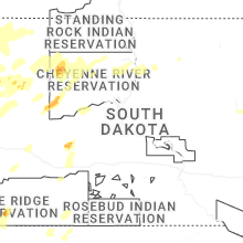
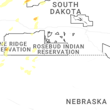
South Dakota
| Local Time | Report Details |
|---|---|
| 6:05 PM MDT | Storm damage reported in oglala lakota county SD, 64 miles SSE of Rapid City, SD |
| 7:45 PM MDT | Storm damage reported in meade county SD, 62.6 miles NNE of Rapid City, SD |
| 7:50 PM MDT | Storm damage reported in meade county SD, 62.6 miles NNE of Rapid City, SD |
| 9:15 PM MDT | Tree uprooted in ziebach county SD, 90.4 miles NW of Pierre, SD |
| 9:45 PM MDT | 73 mph wind gust reported from the sd mesonet 6 miles nnw of lantr in dewey county SD, 74.7 miles NW of Pierre, SD |
Alabama
| Local Time | Report Details |
|---|---|
| 9:06 PM CDT | Tree down on cr 38 in jackson county AL, 41.6 miles SW of Chattanooga, TN |
North Dakota
| Local Time | Report Details |
|---|---|
| 1:43 AM CDT | Quarter sized hail reported near Bismarck, ND, 2.6 miles SSW of Bismarck, ND, report from mping: quarter (1.00 in.). |
| 1:46 AM CDT | Quarter sized hail reported near Bismarck, ND, 3.3 miles SSW of Bismarck, ND, report from mping: quarter (1.00 in.). |
| 1:55 AM CDT | Awos station ky19 manda in morton county ND, 6.2 miles WSW of Bismarck, ND |
Connect with Interactive Hail Maps