

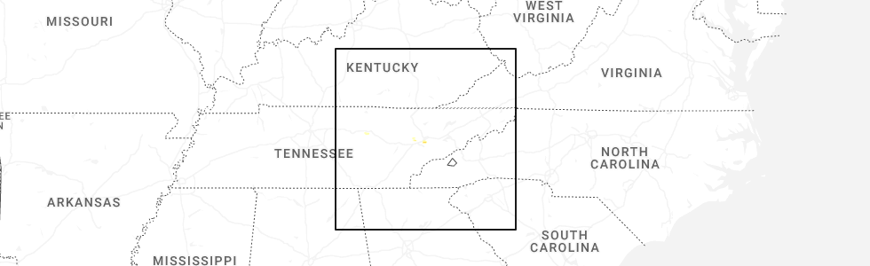
Hail Map for Thursday, September 4, 2025
Number of Impacted Households on 9/4/2025
0
Impacted by 1" or Larger Hail
0
Impacted by 1.75" or Larger Hail
0
Impacted by 2.5" or Larger Hail
Square Miles of Populated Area Impacted on 9/4/2025
0
Impacted by 1" or Larger Hail
0
Impacted by 1.75" or Larger Hail
0
Impacted by 2.5" or Larger Hail
Cities Most Affected by Hail Storms of 9/4/2025
| Hail Size | Demographics of Zip Codes Affected | ||||||
|---|---|---|---|---|---|---|---|
| City | Count | Average | Largest | Pop Density | House Value | Income | Age |
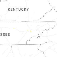
| Knoxville, TN | 1 | 1.75 | 1.75 | 960 | $112k | $45.3k | 37.0 |
Hail and Wind Damage Spotted on 9/4/2025
Filter by Report Type:Hail ReportsWind Reports
States Impacted
Kentucky, Tennessee, New York, North Carolina, Virginia, Minnesota, Pennsylvania, Oregon, Texas, Arizona, CaliforniaKentucky
| Local Time | Report Details |
|---|---|
| 10:38 AM EDT | Picture on social media of downed trees blocking fairview road in middlesboro between mudlick road and gordon lane. time estimated via rada in bell county KY, 45.2 miles NNE of Knoxville, TN |
| 10:39 AM EDT | The middlesboro police department posted pictures of a large tree down on balmoral road in between pike road and rochester avenue. the tree fell on power lines... and a in bell county KY, 45.5 miles NNE of Knoxville, TN |
Tennessee
| Local Time | Report Details |
|---|---|
| 11:00 AM EDT | Reports of several trees down along cedar fork road east of tazewel in claiborne county TN, 42.8 miles NNE of Knoxville, TN |
| 12:25 PM EDT | Trees down across cedar creek r in hamblen county TN, 44.3 miles ENE of Knoxville, TN |
| 12:30 PM EDT | Social media photos of downed trees and power lines. time estimated based on rada in sullivan county TN, 11.6 miles ESE of Bristol, TN |
| 12:55 PM EDT | Report of trees and powerlines down near fairview rd and coalfield school. currently does not look to be located near where the funnel cloud was reporte in morgan county TN, 28.4 miles W of Knoxville, TN |
| 1:00 PM EDT | Trees blown down onto power line in greene county TN, 44.3 miles SW of Bristol, TN |
| 1:30 PM EDT | Quarter sized hail reported near Knoxville, TN, 12.9 miles W of Knoxville, TN, nickel to quarter-sized hail near hardin valley area. |
| 1:30 PM EDT | Half Dollar sized hail reported near Knoxville, TN, 15.1 miles W of Knoxville, TN, broadcast media report of half dollar size hail off of solway road. similar report in karns. |
| 1:35 PM EDT | Golf Ball sized hail reported near Knoxville, TN, 10.7 miles W of Knoxville, TN, social media photo of multiple golf ball size hail stones. |
| 1:35 PM EDT | Ping Pong Ball sized hail reported near Knoxville, TN, 10.1 miles W of Knoxville, TN |
| 2:07 PM EDT | Quarter sized hail reported near Knoxville, TN, 3.8 miles SSW of Knoxville, TN, report from mping: quarter (1.00 in.). |
| 2:30 PM EDT | Large tree branch (6-8in) snapped off blocking stone mill d in knox county TN, 8.4 miles WSW of Knoxville, TN |
| 2:35 PM EDT | Quarter sized hail reported near Sevierville, TN, 19.7 miles ESE of Knoxville, TN, social media video of dime to quarter size hail... time estimated based on radar. |
| 2:40 PM EDT | Trees down around walter state colleg in sevier county TN, 24.6 miles ESE of Knoxville, TN |
| 2:45 PM EDT | Large tree down over power line in sevier county TN, 13.8 miles ESE of Knoxville, TN |
| 2:55 PM EDT | Social media photo of large tree down across the road. time estimated based on rada in sevier county TN, 10.1 miles ESE of Knoxville, TN |
| 2:57 PM EDT | Quarter sized hail reported near Knoxville, TN, 11.2 miles WSW of Knoxville, TN, report from mping: quarter (1.00 in.). |
| 3:20 PM EDT | Several trees knocked down around mooresbur in hawkins county TN, 47 miles NE of Knoxville, TN |
| 3:20 PM EDT | Several trees knocked down around mooresbur in sevier county TN, 10.1 miles ESE of Knoxville, TN |
| 3:50 PM EDT | Tree limbs dow in roane county TN, 28.2 miles W of Knoxville, TN |
New York
| Local Time | Report Details |
|---|---|
| 12:30 PM EDT | A few reports of trees down in the town of genev in ontario county NY, 44.7 miles WSW of Syracuse, NY |
| 1:12 PM EDT | Trees and wires down on emerson r in cayuga county NY, 22.1 miles W of Syracuse, NY |
| 1:12 PM EDT | Trees down on cooper stree in cayuga county NY, 25.4 miles WNW of Syracuse, NY |
| 1:43 PM EDT | Trees and wires down on peter scott r in oswego county NY, 15.8 miles NNW of Syracuse, NY |
| 2:14 PM EDT | Tree down on dog hill r in jefferson county NY, 44 miles SSW of Ogdensburg, NY |
| 2:30 PM EDT | Tree down down on alexander stree in jefferson county NY, 46.4 miles SSW of Ogdensburg, NY |
| 3:12 PM EDT | Tree down on new york route 81 in st. lawrence county NY, 33.2 miles S of Ogdensburg, NY |
| 3:40 PM EDT | Tree down on ny-37 near serenity view campgroun in st. lawrence county NY, 11.9 miles NE of Ogdensburg, NY |
| 3:55 PM EDT | Tree down on wires and on fire at the intersection of state route 49 and meadowbrook lan in oswego county NY, 17.4 miles N of Syracuse, NY |
| 3:58 PM EDT | Tree down on ny-37 near serenity view campgroun in st. lawrence county NY, 11.9 miles NE of Ogdensburg, NY |
| 6:01 PM EDT | Large tree down. time estimated from rada in oneida county NY, 42.3 miles NE of Syracuse, NY |
| 6:02 PM EDT | Photo of tree down on a house on flint town road. time and exact location estimated by rada in oneida county NY, 43.5 miles NE of Syracuse, NY |
North Carolina
| Local Time | Report Details |
|---|---|
| 1:30 PM EDT | Tree down on a power line on staggs creek road in warrensville... n in ashe county NC, 38.3 miles ESE of Bristol, TN |
| 1:38 PM EDT | Utility line damage leading to outages along culvin creek roa in madison county NC, 48 miles SSW of Bristol, TN |
| 2:38 PM EDT | Tree down blocking country club roa in surry county NC, 63.7 miles SW of Roanoke, VA |
| 2:38 PM EDT | Tree down in the road near intersection of crossroad church road and judsville school road. time estimated from rada in surry county NC, 76.7 miles SW of Roanoke, VA |
| 2:38 PM EDT | Thunderstorm winds downed a tree at the intersection of edgewood road and walker street. time estimate in wilkes county NC, 64.8 miles NNW of Charlotte, NC |
| 2:47 PM EDT | Tree down on springs road near riverside drive. time estimated from rada in surry county NC, 62.5 miles SW of Roanoke, VA |
| 2:48 PM EDT | Tree down near turkey ford baptist church. time estimated from rada in surry county NC, 72.7 miles SSW of Roanoke, VA |
| 2:50 PM EDT | Tree down on edgewood road near its intersection with walker street. time estimated from rada in wilkes county NC, 64.8 miles NNW of Charlotte, NC |
| 2:53 PM EDT | Tree down near intersection of snody road and athey simmons roa in surry county NC, 60.7 miles SSW of Roanoke, VA |
| 2:57 PM EDT | Two trees down near mount herman church and brim roa in surry county NC, 58.7 miles SSW of Roanoke, VA |
| 2:58 PM EDT | Tree down near intersection of brim road and sheba trai in surry county NC, 58.3 miles SSW of Roanoke, VA |
| 3:02 PM EDT | Tree down along w mount herman church and us 601 intersectio in surry county NC, 73.8 miles N of Charlotte, NC |
| 3:04 PM EDT | Tree down near intersection of wild boys lane and albion church roa in surry county NC, 60.2 miles SSW of Roanoke, VA |
| 3:04 PM EDT | Tree down blocking one lane of woodville church roa in surry county NC, 60.6 miles SSW of Roanoke, VA |
| 3:46 PM EDT | Tree down on dillard road in dillard. time estimated from rada in stokes county NC, 60.7 miles S of Roanoke, VA |
| 3:57 PM EDT | Tree down along pine hall road. time estimated from rada in stokes county NC, 65.9 miles S of Roanoke, VA |
| 5:05 PM EDT | Quarter sized hail reported near Black Mountain, NC, 56.5 miles NNE of Greenville, SC, observed along laurel circle. |
| 5:20 PM EDT | Trees downed near ivey church and union church road in lincoln county NC, 28.5 miles NW of Charlotte, NC |
| 5:30 PM EDT | Utility damage leading to outages near brawley school r in iredell county NC, 23.1 miles NNW of Charlotte, NC |
| 5:40 PM EDT | Social media report of large branches downed along unity church r in lincoln county NC, 20.1 miles NNW of Charlotte, NC |
| 8:35 PM EDT | Downed trees and/or utility lines leading to power outage in rutherford county NC, 48.9 miles ENE of Greenville, SC |
Virginia
| Local Time | Report Details |
|---|---|
| 2:11 PM EDT | *** 1 inj *** tree fell on camper resulting in one injur in grayson county VA, 69.2 miles E of Bristol, TN |
| 2:16 PM EDT | Tree down on cliffview road near the ranger station on the new river trail. time estimated from rada in carroll county VA, 67.8 miles SW of Roanoke, VA |
| 2:20 PM EDT | Roof blown off of building with people still insid in city of galax county VA, 65.6 miles SW of Roanoke, VA |
| 2:22 PM EDT | Tree down on cranberry road near kenwood lane. time estimated from rada in carroll county VA, 64.3 miles SW of Roanoke, VA |
| 2:44 PM EDT | Tree fell onto a power line on webbs mill road near its intersection with nursery lane. time estimated from rada in floyd county VA, 32 miles SW of Roanoke, VA |
| 2:49 PM EDT | Power lines downed on noble avenue ne near the intersection with courtland road ne. time estimated from rada in city of roanoke county VA, 1.3 miles N of Roanoke, VA |
| 2:54 PM EDT | Power line down along sunrise avenu in city of roanoke county VA, 2 miles NNW of Roanoke, VA |
| 2:55 PM EDT | Power line down near the intersection of herberger road nw and peters creek road nw. time estimated from rada in city of roanoke county VA, 4.3 miles WNW of Roanoke, VA |
| 2:55 PM EDT | Power lines down along stewart avenu in city of roanoke county VA, 1.1 miles E of Roanoke, VA |
| 2:57 PM EDT | Power lines down on dell avenue near its intersection with ceylon street ne. time estimated from rada in city of roanoke county VA, 2.6 miles ENE of Roanoke, VA |
| 3:00 PM EDT | A few trees were downed near stewartsvill in bedford county VA, 5.6 miles E of Roanoke, VA |
| 3:11 PM EDT | Tree down blocking iron ridge road near the bridge over little creek. time estimated from rada in franklin county VA, 15.4 miles S of Roanoke, VA |
| 4:06 PM EDT | Power lines down along smoky hollow roa in campbell county VA, 49.3 miles E of Roanoke, VA |
| 4:07 PM EDT | Tree down near intersection of oxford furnace road and country roa in campbell county VA, 49.8 miles E of Roanoke, VA |
| 4:23 PM EDT | Power line snapped along calvary roa in halifax county VA, 61.4 miles NNW of Raleigh, NC |
| 4:51 PM EDT | Tree blown down along cherry hill church roa in halifax county VA, 60.1 miles NNW of Raleigh, NC |
| 4:53 PM EDT | 20-30 trees blown down... multiple power lines down... power pole snapped on newton farm roa in halifax county VA, 60.6 miles NNW of Raleigh, NC |
| 4:55 PM EDT | Tree down blocking road near intersection of east hyco and loftis roa in halifax county VA, 61.1 miles NNW of Raleigh, NC |
| 5:27 PM EDT | Trees reported down along us-15 in the town of clarksville. time is radar estimate in mecklenburg county VA, 57.7 miles N of Raleigh, NC |
| 6:57 PM EDT | Report of large tree down off the side of the road on i-95 northbound near mile marker 60. time estimated via rada in chesterfield county VA, 17.8 miles SE of Richmond, VA |
Minnesota
| Local Time | Report Details |
|---|---|
| 5:23 PM CDT | Awos station kgdb granite falls a in yellow medicine county MN, 16.2 miles SSE of Montevideo, MN |
| 5:24 PM CDT | Awos station kmml marshall municipal airpor in lyon county MN, 35 miles S of Montevideo, MN |
| 5:29 PM CDT | A 3 inch tree was snapped half way down by thunderstorm wind gust in lyon county MN, 50.4 miles S of Montevideo, MN |
| 6:20 PM CDT | Mping report of 3 inch tree limbs broke in cottonwood county MN, 81 miles SSE of Montevideo, MN |
Pennsylvania
| Local Time | Report Details |
|---|---|
| 6:45 PM EDT | Wires down on road. time estimated using rada in columbia county PA, 51.4 miles WSW of Scranton, PA |
Oregon
| Local Time | Report Details |
|---|---|
| 4:43 PM PDT | Mesonet station wtfo3 wagontir in harney county OR, 45.3 miles WSW of Burns, OR |
Texas
| Local Time | Report Details |
|---|---|
| 7:53 PM CDT | Most likely caused by virga as winds gusted from the west-southwest with the only near by thunderstorm to the northeas in hansford county TX, 87.6 miles NNE of Amarillo, TX |
Arizona
| Local Time | Report Details |
|---|---|
| 6:23 PM MST | 58 mph wind gust measured at the mohawk dunes raws statio in yuma county AZ, 51.6 miles E of Yuma, AZ |
| 6:30 PM MST | Bakers tank raws measured a 58 mph gust. timing adjusted based on rada in yuma county AZ, 36.1 miles E of Yuma, AZ |
| 7:42 PM MST | Highway 95 shut down due to a downed power line. timing estimated from rada in yuma county AZ, 11.5 miles E of Yuma, AZ |
| 8:10 PM MST | Power line dow in yuma county AZ, 3.8 miles S of Yuma, AZ |
| 8:10 PM MST | 60 mph peak wind gust measured at yuma international airport (knyl in yuma county AZ, 2.6 miles SSE of Yuma, AZ |
| 8:21 PM MST | Power line down. time estimated from rada in yuma county AZ, 1.1 miles NNE of Yuma, AZ |
| 8:25 PM MST | At least a couple power lines down along avenue a near 3rd st and 5th st. timing estimated from rada in yuma county AZ, 2.4 miles N of Yuma, AZ |
California
| Local Time | Report Details |
|---|---|
| 8:25 PM PDT | Tree down on railroad ave blocking both lanes. time estimated from rada in imperial county CA, 3.9 miles NNW of Yuma, AZ |
Connect with Interactive Hail Maps