

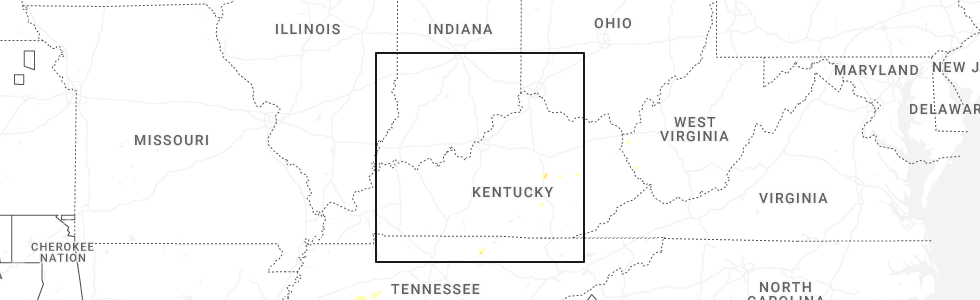
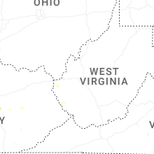
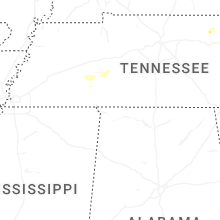
Hail Map for Friday, September 5, 2025
Number of Impacted Households on 9/5/2025
0
Impacted by 1" or Larger Hail
0
Impacted by 1.75" or Larger Hail
0
Impacted by 2.5" or Larger Hail
Square Miles of Populated Area Impacted on 9/5/2025
0
Impacted by 1" or Larger Hail
0
Impacted by 1.75" or Larger Hail
0
Impacted by 2.5" or Larger Hail
Cities Most Affected by Hail Storms of 9/5/2025
| Hail Size | Demographics of Zip Codes Affected | ||||||
|---|---|---|---|---|---|---|---|
| City | Count | Average | Largest | Pop Density | House Value | Income | Age |
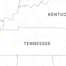
| Whitleyville, TN | 1 | 2.50 | 2.50 | 14 | $42k | $25.0k | 45.6 |
| Gainesboro, TN | 1 | 1.75 | 1.75 | 50 | $70k | $26.5k | 44.7 |
Hail and Wind Damage Spotted on 9/5/2025
Filter by Report Type:Hail ReportsWind Reports
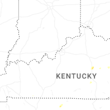
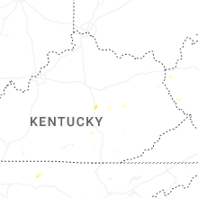
Kentucky
| Local Time | Report Details |
|---|---|
| 6:04 PM EDT | Picture on social media of a large downed tree blocking ky-1092 between flatgap and drake fork road. time estimated via rada in johnson county KY, 60.6 miles ENE of Irvine, KY |
| 5:12 PM CDT | Report of large tree down on orndorff mill r in logan county KY, 37.5 miles NNW of Nashville, TN |
| 6:18 PM EDT | Tree down on power line at the intersection of ky hwy 11 and ky highway 71 in wolfe county KY, 16.7 miles E of Irvine, KY |
| 5:40 PM CDT | Large tree down on salem rd... mostly blocking the road. off duty officer tried to move but was unabl in simpson county KY, 44.1 miles NNE of Nashville, TN |
| 6:05 PM CDT | Dispatch reported a tree down on a power line resulting in a power outag in allen county KY, 51.8 miles NE of Nashville, TN |
| 7:35 PM EDT | Quarter sized hail reported near Somerset, KY, 46.5 miles SW of Irvine, KY, multiple pictures on social media of measured quarter-sized hail in shopville... ky. time estimated via radar. |
| 8:30 PM EDT | Report of trees down on three forks rd. and boone trail r in madison county KY, 19.4 miles WNW of Irvine, KY |
| 9:40 PM EDT | Ping Pong Ball sized hail reported near Berea, KY, 15.5 miles WSW of Irvine, KY, ping pong size hail. |
| 11:00 PM EDT | Resends previous tstm wnd dmg report from bethany due to iris error message. social media report of a large tree down on a fence on bethany school lane in wolfe count in wolfe county KY, 27.3 miles E of Irvine, KY |
| 11:01 PM EDT | Social media report of a dumpster that was tossed/flipped from the wind at the bethany christian school. time estimated via rada in wolfe county KY, 27.9 miles E of Irvine, KY |
| 11:06 PM EDT | Social media report of downed trees one mile south of the wolfe/breathitt county line on ky-15. report corroborated with a traffic slowdown on online gps software. time in breathitt county KY, 29.5 miles E of Irvine, KY |
| 11:07 PM EDT | Off-duty nws employee relayed a report of a down tree near the 6000 block of ky-1812. time estimated from rada in wolfe county KY, 31 miles E of Irvine, KY |
| 11:08 PM EDT | Social media report of a downed tree at the vancleve park and ride immediately after the exit ramp from ky-15. time estimated via rada in breathitt county KY, 31.3 miles E of Irvine, KY |
Tennessee
| Local Time | Report Details |
|---|---|
| 5:20 PM CDT | Tree down on cypress creek road near drop anchor rv park. entire road was blocke in perry county TN, 46.8 miles SE of Mc Kenzie, TN |
| 5:24 PM CDT | Tree down on sanderson roa in henderson county TN, 47.9 miles SSE of Mc Kenzie, TN |
| 5:37 PM CDT | Tree down blocking roadway. report originated with highway troope in perry county TN, 53.2 miles SE of Mc Kenzie, TN |
| 5:51 PM CDT | Quarter sized hail reported near Williamsport, TN, 40.3 miles SW of Nashville, TN, social media photos of hail at least quarter size near duck river. time estimated. |
| 6:18 PM CDT | Tree fell on a car along the natchez trace parkwa in lewis county TN, 44 miles NNE of Florence, AL |
| 6:44 PM CDT | Picture of a barn with tin roofing peeled up. time estimated by radar. in lafayette though exact location unknow in macon county TN, 48.6 miles ENE of Nashville, TN |
| 6:44 PM CDT | Quarter sized hail reported near Lafayette, TN, 49 miles ENE of Nashville, TN, social media photos of hail up to quarter size near lafayette. time estimated. |
| 6:48 PM CDT | Social media report of trees and powerlines down in several locations across jackson county. time estimated from rada in jackson county TN, 59.1 miles ENE of Nashville, TN |
| 6:53 PM CDT | Tree down on a mobile home along taurus roa in macon county TN, 54.5 miles ENE of Nashville, TN |
| 6:57 PM CDT | Tennis Ball sized hail reported near Whitleyville, TN, 64.8 miles ENE of Nashville, TN, picture received of tennis ball size hail on social media from whitleyville. time estimated from radar. |
| 7:07 PM CDT | Golf Ball sized hail reported near Gainesboro, TN, 63.8 miles ENE of Nashville, TN, pictures received on social media of large hail being held. public reports golf ball size. |
| 7:15 PM CDT | Many trees down on west end of clay county. time estimated from rada in clay county TN, 67.2 miles ENE of Nashville, TN |
| 7:56 PM CDT | 56 mph wind gust reported via automated weather senso in jackson county TN, 63.7 miles ENE of Nashville, TN |
| 8:07 PM CDT | Trees and powerlines down on a home. time estimated from rada in overton county TN, 85.3 miles WNW of Knoxville, TN |
West Virginia
| Local Time | Report Details |
|---|---|
| 7:13 PM EDT | Over 500 homes in the shively area without power due to tree damage along main hart road. time estimated from rada in logan county WV, 38.3 miles SW of Charleston, WV |
| 7:23 PM EDT | Tree damage along route 152 resulted in over 100 local homes to be without powe in wayne county WV, 48.7 miles WSW of Charleston, WV |
| 7:26 PM EDT | Portions of a downed tree fell onto a home in the lenore area heading towards laurel creek lake. time estimated from rada in mingo county WV, 50.7 miles SW of Charleston, WV |
| 7:30 PM EDT | Tree down blocking hensley big branch road near lenore... wv. time estimated by rada in mingo county WV, 51.5 miles SW of Charleston, WV |
| 7:31 PM EDT | Mingo county 911 reports a tree down blocking the road in the 500 block of right fork laurel cr in laurel creek. time estimated via rada in mingo county WV, 48 miles SW of Charleston, WV |
| 7:34 PM EDT | Mingo county 911 reports a tree down involving power lines and a vehicle around the 800 block of day star rd near belo... wv. time is estimated by rada in mingo county WV, 51 miles SW of Charleston, WV |
| 7:39 PM EDT | Logan county 911 reports a tree down in the 200 block of hanging rock hwy in logan. tree is blocking one side of the road. time estimated by rada in logan county WV, 39.5 miles SSW of Charleston, WV |
| 7:40 PM EDT | Logan county 911 center reports a tree and a power line down in the 100 block area of gentry ave in logan... wv. time estimated by rada in logan county WV, 41.1 miles SSW of Charleston, WV |
| 7:42 PM EDT | Local utility company reports power outages affecting 70-100 some customers in the myrtle and delbarton areas due to downed trees. time estimated by rada in mingo county WV, 50.6 miles SW of Charleston, WV |
| 8:00 PM EDT | Tree damage along conrad run road resulted in over 200 homes to be without power near the community of hazelgreen. time estimated from rada in ritchie county WV, 62.2 miles W of Elkins, WV |
| 8:21 PM EDT | A downed tree was observed along pullman drive in coxs mills. time estimated from rada in gilmer county WV, 54.7 miles WNW of Elkins, WV |
Texas
| Local Time | Report Details |
|---|---|
| 6:19 PM CDT | Denton enterprise airport recorded a 63 mph wind gust with strong winds behind the outflow boundary of a severe stor in denton county TX, 37.4 miles NW of Dallas, TX |
| 6:35 PM CDT | A home weather station in robson ranch recorded a 60 mph wind gus in denton county TX, 35.9 miles NW of Dallas, TX |
| 6:40 PM CDT | Denton enterprise airport recorded a 75 mph wind gust. minor damage was reported to a hanger... and a number of small planes were damage in denton county TX, 37.4 miles NW of Dallas, TX |
| 7:03 PM CDT | Lots of tree damage and broken tree damage in aubre in denton county TX, 38.3 miles NNW of Dallas, TX |
| 7:03 PM CDT | Half Dollar sized hail reported near Aubrey, TX, 32.6 miles NNW of Dallas, TX, report from mping: half dollar (1.25 in.). |
| 7:05 PM CDT | Quarter sized hail reported near Little Elm, TX, 30.9 miles NNW of Dallas, TX, report from mping: quarter (1.00 in.). |
| 7:05 PM CDT | Mesonet station twb73 mustang special utility district on fm 293 in denton county TX, 37.6 miles NNW of Dallas, TX |
| 7:19 PM CDT | The roof covering and wood boards were partially torn off the side of a house in north preston lakes... north of celin in collin county TX, 41.5 miles N of Dallas, TX |
| 7:24 PM CDT | Shingle and small limb damage in gunter reported via faceboo in grayson county TX, 46.4 miles N of Dallas, TX |
| 7:24 PM CDT | Half Dollar sized hail reported near Celina, TX, 36.1 miles N of Dallas, TX, report from mping: half dollar (1.25 in.). |
| 7:25 PM CDT | The roof of a horse barn collapsed along massey road to the east of gunter. this was reported via faceboo in grayson county TX, 46.6 miles N of Dallas, TX |
| 7:43 PM CDT | Street signs... tree limbs and trees were reported down across anna. an rv was also blown over on highway 75 on the anna/van alstyne lin in collin county TX, 41.7 miles NNE of Dallas, TX |
| 7:55 PM CDT | Several trees down and 8000 power outages across southern fannin county especially in the trenton and leonard area in fannin county TX, 52.1 miles NNE of Dallas, TX |
| 9:53 PM CDT | Asos station kdto denton enterprise airpor in denton county TX, 37.4 miles NW of Dallas, TX |
| 10:02 PM CDT | Wind gust of 60 mph measured at twu guinn hal in denton county TX, 36.7 miles NNW of Dallas, TX |
| 10:18 PM CDT | Report of a single tree down within the city limits of clarksvill in red river county TX, 73.4 miles WSW of Nashville, AR |
North Carolina
| Local Time | Report Details |
|---|---|
| 9:18 PM EDT | Tree down blocking portion of key road near ararat roa in surry county NC, 71.2 miles SSW of Roanoke, VA |
Arkansas
| Local Time | Report Details |
|---|---|
| 11:00 PM CDT | Corrects previous tstm wnd dmg report from 1 s gillham. report of tree down along highway 71 south of gillha in sevier county AR, 30.3 miles WNW of Nashville, AR |
| 11:02 PM CDT | Corrects previous tstm wnd dmg report from 1 wnw de queen. reports of trees down on johnson bridge road just off of highway 70 in sevier county AR, 30.3 miles WNW of Nashville, AR |
| 11:02 PM CDT | Corrects previous tstm wnd dmg report from 2 sse de queen. report of trees down on east red bridge road just to the south of highway 4 in sevier county AR, 28.2 miles W of Nashville, AR |
| 11:27 PM CDT | Corrects previous tstm wnd dmg report from 3 wnw dierks. report of tree down on dierks lake roa in howard county AR, 18.9 miles NW of Nashville, AR |
| 12:48 AM CDT | Report of a powerline down on county road 27 north of stamp in lafayette county AR, 43.3 miles SSE of Nashville, AR |
| 12:50 AM CDT | Report of trees down near hilltop drive on the north side of stamp in lafayette county AR, 44.8 miles SSE of Nashville, AR |
Connect with Interactive Hail Maps