

Hail Map for Friday, July 23, 2021

Number of Impacted Households on 7/23/2021
0
Impacted by 1" or Larger Hail
0
Impacted by 1.75" or Larger Hail
0
Impacted by 2.5" or Larger Hail
Square Miles of Populated Area Impacted on 7/23/2021
0
Impacted by 1" or Larger Hail
0
Impacted by 1.75" or Larger Hail
0
Impacted by 2.5" or Larger Hail


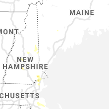


Cities Most Affected by Hail Storms of 7/23/2021
| Hail Size | Demographics of Zip Codes Affected | ||||||
|---|---|---|---|---|---|---|---|
| City | Count | Average | Largest | Pop Density | House Value | Income | Age |
| Northome, MN | 1 | 2.00 | 2.00 | 2 | $57k | $27.3k | 50.0 |
| Corona, NM | 1 | 1.75 | 1.75 | 0 | $47k | $34.1k | 52.3 |
| Madison, NH | 1 | 1.75 | 1.75 | 30 | $108k | $45.3k | 46.4 |
Hail and Wind Damage Spotted on 7/23/2021
Filter by Report Type:Hail ReportsWind Reports
States Impacted
New Hampshire, Georgia, New Mexico, Minnesota, Massachusetts, Colorado, Maine, South Carolina, South Dakota, Nevada, North DakotaNew Hampshire
| Local Time | Report Details |
|---|---|
| 12:35 PM EDT | Half Dollar sized hail reported near Effingham, NH, 38.1 miles W of Portland, ME, observed hail up to 1.25 inch; near the intersection of highway 153 and old pound rd. hail lasted about 3 minutes. gusty winds occurred as well. |
| 1:00 PM EDT | Quarter sized hail reported near Effingham, NH, 39.5 miles W of Portland, ME, quarter-sized hail fell from approximately 12:55 to 1pm at the pine river state forest. measured hail with ruler. |
| 2:25 PM EDT | Multiple branches down due to thunderstorm wind in carroll county NH, 47.7 miles WNW of Portland, ME |
| 2:25 PM EDT | Golf Ball sized hail reported near Madison, NH, 45.8 miles WNW of Portland, ME, golf ball size hail reported... which cracked a car windshield. |
| 2:25 PM EDT | Several tree branches down across the area. time estimated based on rada in carroll county NH, 45.8 miles WNW of Portland, ME |
| 2:50 PM EDT | Quarter sized hail reported near Moultonborough, NH, 60.9 miles W of Portland, ME |
| 2:50 PM EDT | A tree down along with several tree limbs on bennett roa in carroll county NH, 43.6 miles WNW of Portland, ME |
| 2:50 PM EDT | Quarter sized hail reported near Freedom, NH, 43.6 miles WNW of Portland, ME, bennett road. |
| 4:25 PM EDT | Tree limbs down due to wind in merrimack county NH, 73 miles W of Portland, ME |
| 4:25 PM EDT | Quarter sized hail reported near Hill, NH, 73.5 miles W of Portland, ME |
| 4:30 PM EDT | Half Dollar sized hail reported near Kingston, NH, 64 miles SW of Portland, ME |
| 4:35 PM EDT | Trees down on borrage and penacock road in merrimack county NH, 78.9 miles WSW of Portland, ME |
| 4:53 PM EDT | Ping Pong Ball sized hail reported near Contoocook, NH, 78.8 miles WSW of Portland, ME |
| 4:53 PM EDT | Branches down on briar hill roa in merrimack county NH, 77.6 miles WSW of Portland, ME |
| 5:00 PM EDT | Half Dollar sized hail reported near Weare, NH, 79.7 miles WSW of Portland, ME, occurred at hopkinton reservoir. |
Georgia
| Local Time | Report Details |
|---|---|
| 1:00 PM EDT | Tree down across roadway along hwy 12 in twiggs county GA, 87.5 miles SE of Atlanta, GA |
| 1:51 PM EDT | Tree down near intersection of langston and lake joy roa in houston county GA, 83.1 miles NW of Douglas, GA |
| 2:15 PM EDT | Tree down along county line roa in houston county GA, 71.4 miles NW of Douglas, GA |
| 3:30 PM EDT | Large truck trailer blew over in strong winds near jr suber road and ellenton norman roa in colquitt county GA, 49.6 miles WSW of Douglas, GA |
| 3:41 PM EDT | Tree down on rountree bridge roa in cook county GA, 43 miles WSW of Douglas, GA |
| 5:30 PM EDT | Numerous trees reported down within the grant park/glenwood park/ormewood park/east atlanta villiage neighborhoods in east atlant in fulton county GA, 1.9 miles ESE of Atlanta, GA |
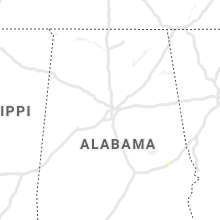
New Mexico
| Local Time | Report Details |
|---|---|
| 2:34 PM MDT | Golf Ball sized hail reported near Corona, NM, 76.5 miles SE of Albuquerque, NM |
| 3:30 PM MDT | Large tree limb downed at fruit ave and luna blvd in bernalillo county NM, 0.7 miles WNW of Albuquerque, NM |
Minnesota
| Local Time | Report Details |
|---|---|
| 4:05 PM CDT | Quarter sized hail reported near Ponemah, MN, 39.9 miles N of Bemidji, MN, public report of 1 inch hail in ponemah. |
| 4:30 PM CDT | Koochiching county dispatch reported a tree down on a power line along county road 2 just south of cripple creek. time estimated from rada in koochiching county MN, 3 miles SSW of International Falls, MN |
| 4:53 PM CDT | Hen Egg sized hail reported near Northome, MN, 34.2 miles NE of Bemidji, MN, numerous 1" hail stones with 2" ones mixed in. |
| 5:30 PM CDT | Spotter reported a tree down onto power lines about two miles west of their home. time estimated by rada in itasca county MN, 37.2 miles ENE of Bemidji, MN |
| 5:39 PM CDT | The spotter reported a few trees down at his location and his power was ou in itasca county MN, 42.5 miles ENE of Bemidji, MN |
| 5:50 PM CDT | Photos shared on social media shows an uprooted red pine tree as well as a white pine broken in half about halfway up the tree. tree heights are estimated to be around in itasca county MN, 41.3 miles ENE of Bemidji, MN |
| 6:23 PM CDT | Quarter sized hail reported near Bemidji, MN, 2.9 miles W of Bemidji, MN, relayed via social media. |
| 6:30 PM CDT | Quarter sized hail reported near Bemidji, MN, 2.9 miles W of Bemidji, MN, relayed via social media. |
| 6:30 PM CDT | Trees down at bemidji high school. time is estimate in beltrami county MN, 0.5 miles N of Bemidji, MN |
| 6:41 PM CDT | Multiple canoes flipped over from thunderstorm wind gusts on trout lake. crew of one canoe unaccounted for. additional water emergencies ongoing in other portions of th in st. louis county MN, 67.2 miles SE of International Falls, MN |
| 6:46 PM CDT | Photo and report received via social media of trees down and damage to tents at a festival in downtown ely. time estimated by rada in st. louis county MN, 77.6 miles N of Duluth, MN |
| 6:46 PM CDT | Numerous reports of trees down in ely with multiple roads blocked. time estimated by rada in st. louis county MN, 77.6 miles N of Duluth, MN |
| 6:47 PM CDT | Photos and measurements were received from the damaged trees in whiteside park. the two largest trees were elms. one was uprooted and had a diameter of 1 foot at the ba in st. louis county MN, 77.6 miles N of Duluth, MN |
| 7:45 PM CDT | Power lines were reported down on trees along mitawan lake road northwest of isabella. time estimated by rada in lake county MN, 66.7 miles NNE of Duluth, MN |
| 8:40 PM CDT | Two trees were reported down north of highway 8 along highway 7. time estimated by rada in st. louis county MN, 23.8 miles WNW of Duluth, MN |
| 8:42 PM CDT | Three trees were downed 1 mile south of highway 8 along highway 7 with one tree completely blocking the road. time estimated by rada in st. louis county MN, 23.2 miles WNW of Duluth, MN |
| 12:47 AM CDT | Quarter sized hail reported near Detroit Lakes, MN, 46.8 miles E of Fargo, ND, hail on east side of big detroit lake. |
| 12:50 AM CDT | Measured wind gust on personal weather statio in wilkin county MN, 32.9 miles SSE of Fargo, ND |
| 1:08 AM CDT | Half Dollar sized hail reported near Frazee, MN, 52.3 miles E of Fargo, ND |
| 1:15 AM CDT | Measured by personal weather statio in grant county MN, 68.7 miles NNW of Montevideo, MN |
| 1:15 AM CDT | Measured on personal weather station in north ottawa townshi in grant county MN, 67.4 miles SSE of Fargo, ND |
| 1:30 AM CDT | 3 inch tree limbs dow in otter tail county MN, 53.3 miles SE of Fargo, ND |
| 1:40 AM CDT | Kd39 measured a 60 mph wind gus in stearns county MN, 64.9 miles NE of Montevideo, MN |
| 2:38 AM CDT | Storm damage reported in hubbard county MN, 39.1 miles SSW of Bemidji, MN |
| 3:30 AM CDT | Numerous power lines... 18-24 inch diameter trees down in and around chisago city. time estimated by spotter... corroborated by rada in chisago county MN, 32.3 miles NE of Minneapolis, MN |
| 3:46 AM CDT | Large tree down on state highway 200 approximately 6 miles west of hill city. time estimated based on rada in aitkin county MN, 63.6 miles ESE of Bemidji, MN |
| 5:06 AM CDT | Storm damage reported in st. louis county MN, 5.2 miles NW of Duluth, MN |
Massachusetts
| Local Time | Report Details |
|---|---|
| 5:09 PM EDT | Quarter sized hail reported near Merrimac, MA, 68.4 miles SSW of Portland, ME |
| 5:20 PM EDT | Quarter sized hail reported near Haverhill, MA, 68 miles NNE of Providence, RI |
| 7:49 PM EDT | Large tree branch down in the road at oak street and marilyn way. relayed by amateur radi in plymouth county MA, 30 miles ENE of Providence, RI |
| 7:50 PM EDT | Quarter sized hail reported near Kingston, MA, 38.2 miles ENE of Providence, RI, photos posted to social media. relayed by amateur radio. |
Colorado
| Local Time | Report Details |
|---|---|
| 3:45 PM MDT | 6 power poles blown dow in fremont county CO, 27.9 miles WNW of Pueblo, CO |
Maine
| Local Time | Report Details |
|---|---|
| 6:00 PM EDT | Branches and some large trees down on the south shore of forest lake. time estimated based on rada in cumberland county ME, 11.7 miles NNW of Portland, ME |
| 6:12 PM EDT | Quarter sized hail reported near Baileyville, ME, 70.7 miles ENE of Bangor, ME, photo taken 2 hours after storm of dime to penny size hail. source estimated quarter size hail during the storm. |
South Carolina
| Local Time | Report Details |
|---|---|
| 6:35 PM EDT | Public reported (via social media) a tree down on two vehicles on lindsay r in pickens county SC, 16.3 miles SW of Greenville, SC |
South Dakota
| Local Time | Report Details |
|---|---|
| 5:32 PM MDT | Half Dollar sized hail reported near Prairie City, SD, 93 miles N of Rapid City, SD, wind gust estimated at 40 mph |
| 6:30 PM MDT | Quarter sized hail reported near Lemmon, SD, 105.2 miles SW of Bismarck, ND, mostly pea to dime size... a few pieces the size of a quarter. |
| 7:20 PM MDT | Storm damage reported in perkins county SD, 84.6 miles SW of Bismarck, ND |
| 7:20 PM MDT | Quarter sized hail reported near Lemmon, SD, 83.9 miles SW of Bismarck, ND |
| 7:25 PM MDT | Quarter sized hail reported near Lemmon, SD, 86.1 miles SW of Bismarck, ND |
| 7:25 PM MDT | Storm damage reported in perkins county SD, 86.1 miles SW of Bismarck, ND |
| 8:16 PM MDT | Mesonet station 205 mclaughlin (sddot in corson county SD, 66.3 miles S of Bismarck, ND |
| 10:01 PM CDT | Radar estimated tim in mcpherson county SD, 54.1 miles NW of Aberdeen, SD |
| 10:14 PM CDT | Storm damage reported in mcpherson county SD, 57.8 miles WNW of Aberdeen, SD |
| 10:28 PM CDT | Storm damage reported in marshall county SD, 55.3 miles ENE of Aberdeen, SD |
| 12:14 AM CDT | Storm damage reported in marshall county SD, 55.3 miles ENE of Aberdeen, SD |
| 12:29 AM CDT | Mesonet station 58 victor (sddot in roberts county SD, 66.1 miles S of Fargo, ND |
| 12:59 AM CDT | Mesonet station mrls2 hillhead 3 ws in marshall county SD, 55.5 miles ENE of Aberdeen, SD |
Nevada
| Local Time | Report Details |
|---|---|
| 5:27 PM PDT | Mesonet station pann2 pancake raw in nye county NV, 95.7 miles SW of Ely, NV |
| 6:41 PM PDT | 75mph gust reported at the kane springs raws sit in lincoln county NV, 62.9 miles W of Saint George, UT |
North Dakota
| Local Time | Report Details |
|---|---|
| 9:23 PM CDT | Thunderstorm winds gusting up to 68 mph lasted 15 minutes from 9:23 pm until 9:38 p in mcintosh county ND, 65.3 miles SE of Bismarck, ND |
| 10:15 PM CDT | Storm damage reported in mcintosh county ND, 50.6 miles NW of Aberdeen, SD |
Connect with Interactive Hail Maps