

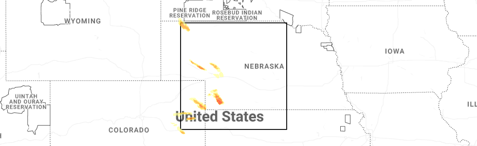
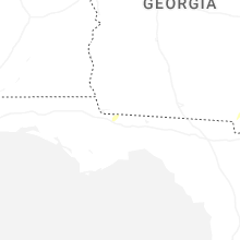
Hail Map for Sunday, June 21, 2026
Number of Impacted Households on 6/21/2026
0
Impacted by 1" or Larger Hail
0
Impacted by 1.75" or Larger Hail
0
Impacted by 2.5" or Larger Hail
Square Miles of Populated Area Impacted on 6/21/2026
0
Impacted by 1" or Larger Hail
0
Impacted by 1.75" or Larger Hail
0
Impacted by 2.5" or Larger Hail
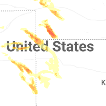
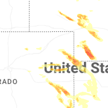
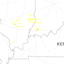
Cities Most Affected by Hail Storms of 6/21/2026
| Hail Size | Demographics of Zip Codes Affected | ||||||
|---|---|---|---|---|---|---|---|
| City | Count | Average | Largest | Pop Density | House Value | Income | Age |
| Wauneta, NE | 4 | 2.74 | 3.20 | 1 | $40k | $30.1k | 50.2 |
| Imperial, NE | 1 | 1.75 | 1.75 | 2 | $67k | $34.4k | 41.3 |
Hail and Wind Damage Spotted on 6/21/2026
Filter by Report Type:Hail ReportsWind Reports
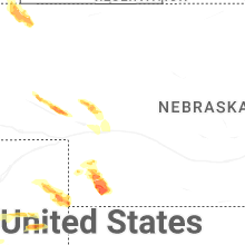
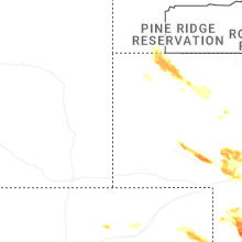
Nebraska
| Local Time | Report Details |
|---|---|
| 12:59 PM MDT | Ping Pong Ball sized hail reported near Lisco, NE, 52.8 miles ESE of Scottsbluff, NE, report via mping. |
| 1:43 PM MDT | Quarter sized hail reported near Imperial, NE, 56.5 miles SW of North Platte, NE, mping report. |
| 1:54 PM MDT | Quarter sized hail reported near Lewellen, NE, 74.3 miles WNW of North Platte, NE |
| 2:14 PM MDT | Half Dollar sized hail reported near Enders, NE, 60 miles SW of North Platte, NE, report from mping: half dollar (1.25 in.). |
| 2:14 PM MDT | Golf Ball sized hail reported near Imperial, NE, 61.8 miles SW of North Platte, NE, mping report. |
| 2:43 PM MDT | Tennis Ball sized hail reported near Wauneta, NE, 65.8 miles SSW of North Platte, NE, report from mping: tennis ball (2.50 in.). |
| 2:52 PM MDT | Hen Egg sized hail reported near Wauneta, NE, 61.5 miles NNW of Colby, KS, report from mping: hen egg+ (2.25 in.). |
| 2:53 PM MDT | Tea Cup sized hail reported near Wauneta, NE, 64.8 miles NNW of Colby, KS, spotter network report: measured with calipers 3 inch hail. |
| 3:02 PM MDT | Personal weather statio in keith county NE, 33.9 miles W of North Platte, NE |
| 3:05 PM MDT | Tea Cup sized hail reported near Wauneta, NE, 63.8 miles NNW of Colby, KS, social media report of pictured 3.2 inch hail measured with calipers. |
| 3:10 PM MDT | Personal weather statio in keith county NE, 37.5 miles W of North Platte, NE |
| 4:20 PM CDT | Quarter sized hail reported near Stratton, NE, 52.9 miles N of Colby, KS, spotter network: report of 1.00 inch hail. |
| 4:20 PM CDT | Ping Pong Ball sized hail reported near Stratton, NE, 52 miles NNW of Colby, KS, report from mping: ping pong ball (1.50 in.). |
Georgia
| Local Time | Report Details |
|---|---|
| 3:15 PM EDT | A pine tree fell across city blvd between seminole trail and baltimore circle. radar estimated tim in ware county GA, 36.5 miles ESE of Douglas, GA |
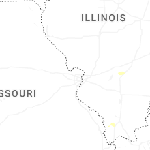
Illinois
| Local Time | Report Details |
|---|---|
| 3:43 PM CDT | Photo of debris strewn in field about one-half mile east of town. possible tornad in cumberland county IL, 11.5 miles SSW of Mattoon, IL |
| 4:01 PM CDT | Multiple trees down... multiple branches strewn about... and power lines down along cr 1900n near n 1300 in fayette county IL, 53.2 miles SW of Mattoon, IL |
| 4:06 PM CDT | Semi flipped over on interstate 57 at neog in cumberland county IL, 10.8 miles SSW of Mattoon, IL |
Colorado
| Local Time | Report Details |
|---|---|
| 2:51 PM MDT | Davis weatherlink station: p&k farms reported a 61 mph gus in yuma county CO, 23.5 miles E of Yuma, CO |
| 2:55 PM MDT | Awos station k2v5 2 nw wra in yuma county CO, 25.1 miles E of Yuma, CO |
| 3:15 PM MDT | Davis weatherlink site: osmus farm reported 64 mph gus in yuma county CO, 29.6 miles ESE of Yuma, CO |
Wyoming
| Local Time | Report Details |
|---|---|
| 3:11 PM MDT | Asos station kriw riverton airport (asos in fremont county WY, 5.5 miles NW of Riverton, WY |
Indiana
| Local Time | Report Details |
|---|---|
| 6:13 PM EDT | Tree branch and shingles blown off by thunderstorm wind in vigo county IN, 51.6 miles E of Mattoon, IL |
| 6:19 PM EDT | Storm damage reported in sullivan county IN, 58.1 miles ESE of Mattoon, IL |
| 6:19 PM EDT | Storm damage reported in sullivan county IN, 58.1 miles ESE of Mattoon, IL |
| 6:19 PM EDT | Storm damage reported in sullivan county IN, 58.1 miles ESE of Mattoon, IL |
Connect with Interactive Hail Maps