

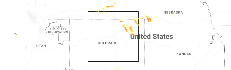
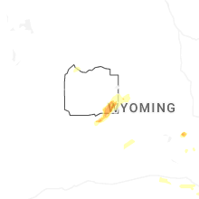
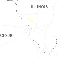
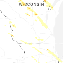
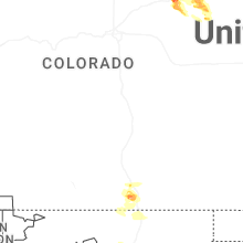
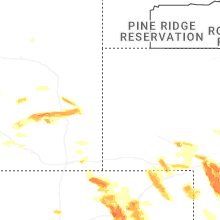
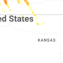
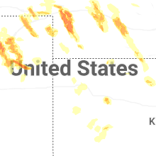
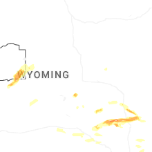
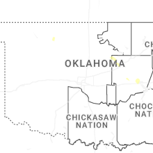
Hail Map for Wednesday, June 24, 2026
Number of Impacted Households on 6/24/2026
0
Impacted by 1" or Larger Hail
0
Impacted by 1.75" or Larger Hail
0
Impacted by 2.5" or Larger Hail
Square Miles of Populated Area Impacted on 6/24/2026
0
Impacted by 1" or Larger Hail
0
Impacted by 1.75" or Larger Hail
0
Impacted by 2.5" or Larger Hail

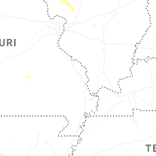
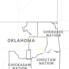
Cities Most Affected by Hail Storms of 6/24/2026
| Hail Size | Demographics of Zip Codes Affected | ||||||
|---|---|---|---|---|---|---|---|
| City | Count | Average | Largest | Pop Density | House Value | Income | Age |
| Fort Morgan, CO | 9 | 2.08 | 2.75 | 26 | $100k | $34.5k | 33.6 |
| Haxtun, CO | 3 | 2.73 | 3.20 | 3 | $78k | $32.3k | 46.3 |
| Grant, NE | 2 | 2.13 | 2.50 | 1 | $62k | $34.1k | 44.7 |
| Trinidad, CO | 2 | 1.75 | 1.75 | 20 | $86k | $28.3k | 42.5 |
| Wauneta, NE | 1 | 2.75 | 2.75 | 1 | $40k | $30.1k | 50.2 |
| Iliff, CO | 1 | 2.50 | 2.50 | 4 | $57k | $35.7k | 41.0 |
| North Platte, NE | 1 | 2.00 | 2.00 | 50 | $79k | $36.3k | 38.7 |
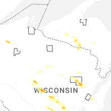
| Pulaski, WI | 1 | 1.75 | 1.75 | 75 | $110k | $48.4k | 37.6 |
| Berthoud, CO | 1 | 1.75 | 1.75 | 147 | $222k | $63.7k | 45.0 |
| Akron, CO | 1 | 1.75 | 1.75 | 2 | $73k | $31.6k | 44.7 |
| Brush, CO | 1 | 1.75 | 1.75 | 22 | $91k | $33.7k | 39.3 |
| Ogallala, NE | 1 | 1.75 | 1.75 | 30 | $72k | $34.3k | 45.5 |
| Green Bay, WI | 1 | 1.75 | 1.75 | 634 | $144k | $63.6k | 40.4 |
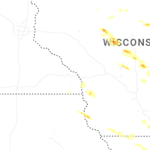
Hail and Wind Damage Spotted on 6/24/2026
Filter by Report Type:Hail ReportsWind Reports
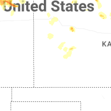
States Impacted
Wisconsin, Florida, Mississippi, Michigan, Utah, Illinois, Alabama, Arizona, Colorado, Wyoming, Nebraska, Indiana, New Mexico, TexasWisconsin
| Local Time | Report Details |
|---|---|
| 12:50 PM CDT | Quarter sized hail reported near Minong, WI, 46.1 miles SSE of Duluth, MN, report via social media photo. location and time approximate. |
| 1:40 PM CDT | Half Dollar sized hail reported near Withee, WI, 77.7 miles SW of Rhinelander, WI |
| 2:10 PM CDT | Half Dollar sized hail reported near Colby, WI, 72.2 miles SW of Rhinelander, WI |
| 2:43 PM CDT | Quarter sized hail reported near Marshfield, WI, 76 miles SSW of Rhinelander, WI, report from mping: quarter (1.00 in.). |
| 2:45 PM CDT | Quarter sized hail reported near Marshfield, WI, 76.8 miles SSW of Rhinelander, WI, report via social media with picture for reference. |
| 3:00 PM CDT | Power lines reported down south of belmon in lafayette county WI, 55.4 miles WSW of Madison, WI |
| 3:22 PM CDT | Tree down at lake rd and sidie hollow r in vernon county WI, 22.4 miles SE of La Crosse, WI |
| 3:34 PM CDT | Half Dollar sized hail reported near Rudolph, WI, 81 miles SSW of Rhinelander, WI, report from mping: half dollar (1.25 in.). |
| 3:46 PM CDT | Half Dollar sized hail reported near Milton, WI, 32.4 miles SE of Madison, WI |
| 4:25 PM CDT | Report of a downed powerlin in adams county WI, 72 miles ENE of La Crosse, WI |
| 4:39 PM CDT | Quarter sized hail reported near Lancaster, WI, 71.7 miles SSE of La Crosse, WI, report from mping: quarter (1.00 in.). |
| 4:56 PM CDT | Half Dollar sized hail reported near Wild Rose, WI, 66.6 miles WSW of Green Bay, WI, report from mping: half dollar (1.25 in.). |
| 5:20 PM CDT | Quarter sized hail reported near Krakow, WI, 20.8 miles NW of Green Bay, WI |
| 5:25 PM CDT | Golf Ball sized hail reported near Pulaski, WI, 14.9 miles NW of Green Bay, WI |
| 5:37 PM CDT | Quarter sized hail reported near Marshfield, WI, 70.9 miles SSW of Rhinelander, WI, report from mping: quarter (1.00 in.). |
| 5:52 PM CDT | Quarter sized hail reported near Green Bay, WI, 4.7 miles WNW of Green Bay, WI |
| 6:00 PM CDT | Golf Ball sized hail reported near Green Bay, WI, 4.8 miles WNW of Green Bay, WI |
| 6:01 PM CDT | Half Dollar sized hail reported near Green Bay, WI, 2.7 miles WNW of Green Bay, WI, report from mping: half dollar (1.25 in.). |
| 6:03 PM CDT | Ping Pong Ball sized hail reported near Green Bay, WI, 3.2 miles NW of Green Bay, WI |
| 6:10 PM CDT | Large tree branch down near intersection of elm st and west st. time est from rada in fond du lac county WI, 52.9 miles NNE of Madison, WI |
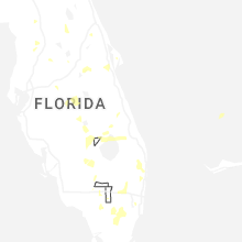
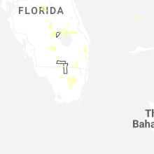
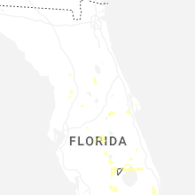
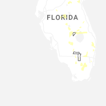
Florida
| Local Time | Report Details |
|---|---|
| 2:51 PM EDT | Quarter sized hail reported near Wellington, FL, 44 miles SSE of Port Saint Lucie, FL, pea to quarter size hail fell around the mall at wellington green. |
| 3:01 PM EDT | Tree was blown down near intersection of erica blvd just south of southern blvd and 441 are in palm beach county FL, 42 miles SSE of Port Saint Lucie, FL |
| 3:08 PM EDT | A tree was blown down and blocked the intersection at the 100 block of saratoga blvd e in royal palm beac in palm beach county FL, 38.1 miles S of Port Saint Lucie, FL |
| 3:17 PM EDT | The weatherflow station at melbourne south db8 measured a peak wind gust of 60mph/52kt from the west at 3:17 p in amz552 county FL, 56.4 miles NNW of Port Saint Lucie, FL |
| 3:37 PM EDT | The weatherflow station at indian river db27 measured a peak wind gust of 64mph/56kt from the north at 3:37 p in amz552 county FL, 48.3 miles NNW of Port Saint Lucie, FL |
| 5:25 PM EDT | The mesonet station wn4mdn fort pierce measured a peak wind gust of 58mph/50kt from the northeast at 5:25 p in st. lucie county FL, 22.4 miles WNW of Port Saint Lucie, FL |
| 6:11 PM EDT | Awos station kocf ocala airport - jim taylor fld measured a peak wind of 59 mph due to a downburs in marion county FL, 67.1 miles NW of Orlando, FL |
| 6:45 PM EDT | Sfwmd mesonet lz40 measured a gust to 59 mp in amz610 county FL, 36.8 miles SW of Port Saint Lucie, FL |
| 7:30 PM CDT | Tree down blocking the westbound lane on hwy 90 at the walton/holmes county lin in walton county FL, 30.5 miles NE of Miramar Beach, FL |
| 7:55 PM CDT | Elevated beachfront hazcam station reported a wind gust of 60 mp in bay county FL, 40.2 miles ESE of Miramar Beach, FL |
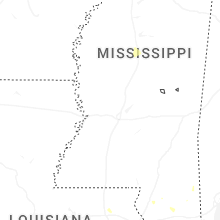
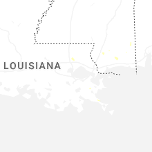
Mississippi
| Local Time | Report Details |
|---|---|
| 2:40 PM CDT | Tree down on a power line in millar in pearl river county MS, 60.6 miles NNE of New Orleans, LA |
| 3:10 PM CDT | Tree down on a power line on go go road in the silver hill are in pearl river county MS, 69.3 miles NE of New Orleans, LA |
| 3:25 PM CDT | Trees reported down on north carr bridge r in harrison county MS, 54.9 miles W of Mobile, AL |
| 3:35 PM CDT | Trees reported down on old biloxi roa in jackson county MS, 47 miles W of Mobile, AL |
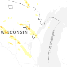
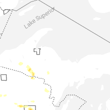
Michigan
| Local Time | Report Details |
|---|---|
| 3:46 PM EDT | Quarter sized hail reported near Trout Creek, MI, 55 miles NNE of Rhinelander, WI, image from social media of a hail stone the size of a quarter at bond falls. |
| 4:25 PM CDT | Quarter sized hail reported near Caspian, MI, 47.6 miles NE of Rhinelander, WI, estimated hail the size of quarters reported from local gas station. |
| 4:30 PM CDT | Quarter sized hail reported near Gaastra, MI, 48.8 miles NE of Rhinelander, WI, report from social media of 1 inch hail in gaastra. included pictures confirming size. |
Utah
| Local Time | Report Details |
|---|---|
| 2:00 PM MDT | Blackrock mesonet site (up094) measured wind gust of 62 mph due to nearby thunderstorm in millard county UT, 43.7 miles WNW of Monroe, UT |
| 3:28 PM MDT | Wendover awos (kenv) measured wind gust of 66 mph due to nearby showers and thunderstorm in tooele county UT, 91 miles E of Elko, NV |
| 4:15 PM MDT | Mesonet station vrh vernon hil in tooele county UT, 50.6 miles SSW of Salt Lake City, UT |
| 4:50 PM MDT | Mesonet station ut112 sr-112 at mp 6 utah avenu in tooele county UT, 27.8 miles WSW of Salt Lake City, UT |
| 5:20 PM MDT | Mesonet station utdcd us-189 at deer creek da in wasatch county UT, 30.6 miles SE of Salt Lake City, UT |
| 5:42 PM MDT | Mesonet station rsbu1 rosebu in box elder county UT, 79.4 miles SE of Twin Falls, ID |
| 7:00 PM MDT | Mesonet station pc492 rada in box elder county UT, 45 miles NW of Salt Lake City, UT |
| 8:10 PM MDT | Mesonet station gni gunnison islan in box elder county UT, 63.8 miles NW of Salt Lake City, UT |
Illinois
| Local Time | Report Details |
|---|---|
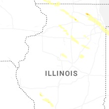
| 4:07 PM CDT | Power lines down in front yar in stephenson county IL, 42.8 miles S of Madison, WI |
| 5:39 PM CDT | Quarter sized hail reported near Huntley, IL, 44.9 miles WNW of Chicago, IL |
| 5:41 PM CDT | Ping Pong Ball sized hail reported near Lake In The Hills, IL, 44 miles WNW of Chicago, IL, public report of 1.5 inch hail near huntly. relayed via mping. |
| 5:42 PM CDT | Quarter sized hail reported near Stillman Valley, IL, 64.2 miles S of Madison, WI, quarter size hail near byron. relayed via amateur radio. time estimated by radar. |
| 5:54 PM CDT | Quarter sized hail reported near Algonquin, IL, 39.3 miles WNW of Chicago, IL, multiple public reports of quarter size hail near algonquin. relayed via mping. |
| 5:55 PM CDT | Quarter sized hail reported near Dundee, IL, 39 miles WNW of Chicago, IL, report from mping: quarter (1.00 in.). |
| 5:55 PM CDT | Quarter sized hail reported near Algonquin, IL, 39.9 miles WNW of Chicago, IL, report from mping: quarter (1.00 in.). |
| 5:57 PM CDT | Quarter sized hail reported near Algonquin, IL, 41.1 miles WNW of Chicago, IL, mchenry county ema reports quarter size hail near randall road and harnish drive. |
| 5:59 PM CDT | Quarter sized hail reported near Algonquin, IL, 37.6 miles WNW of Chicago, IL, public report of quarter size hail southeast of algonquin. relayed via mping. |
| 6:03 PM CDT | 50 to 60 mph wind gusts with torrential rai in whiteside county IL, 78.9 miles N of Peoria, IL |
| 6:10 PM CDT | Large tree branch blown down. time estimated from rada in whiteside county IL, 76.7 miles N of Peoria, IL |
| 6:12 PM CDT | Photo shared on social media showing a large tree branch downed in sleepy hollow. time estimated from rada in kane county IL, 38.2 miles WNW of Chicago, IL |
| 6:13 PM CDT | Kane county ema reported multiple large branches downed near barrington avenue and water street in east dundee. time estimated by rada in kane county IL, 36.5 miles WNW of Chicago, IL |
| 6:26 PM CDT | Quarter sized hail reported near Dekalb, IL, 63 miles W of Chicago, IL, photo shared to social media shows multiple hail stones of nickel size and one stone of quarter size near rich road and schafer road. time estimated by radar. |
| 6:35 PM CDT | Photo shared to social media shows uprooted tree in streamwood. time estimated by social medi in cook county IL, 29.7 miles WNW of Chicago, IL |
| 6:36 PM CDT | Photos shared to social media show numerous large branches downed at bartlett hills golf course. one large tree snaped near the base. small branches scattered across th in cook county IL, 30.3 miles WNW of Chicago, IL |
| 6:36 PM CDT | Tree limbs and power lines blown down in bartlet in cook county IL, 29.8 miles WNW of Chicago, IL |
| 6:38 PM CDT | Four inch diameter tree limbs blown dow in cook county IL, 27.8 miles WNW of Chicago, IL |
| 6:39 PM CDT | Private weather station kilhanovi2 measured a wind gust to 58 mp in dupage county IL, 27.5 miles WNW of Chicago, IL |
| 6:39 PM CDT | Large tree limb snapped and downed onto multiple parked vehicle in cook county IL, 27.7 miles WNW of Chicago, IL |
| 6:39 PM CDT | Large tree branches... fence posts... and fence panels downe in dupage county IL, 28 miles WNW of Chicago, IL |
| 6:40 PM CDT | Six inch diameter tree limb blown down on ring cour in dupage county IL, 27 miles WNW of Chicago, IL |
| 7:24 PM CDT | Storm damage reported in woodford county IL, 14.9 miles ENE of Peoria, IL |
| 7:35 PM CDT | Photos shared to social media show multiple large branches downed... one tree snapped at the base... near 99th street and california avenue. time estimated by rada in cook county IL, 12.4 miles SSW of Chicago, IL |
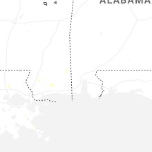
Alabama
| Local Time | Report Details |
|---|---|
| 4:20 PM CDT | Nws employee relayed a tree blocking the road just east of the roundabout at dawes rd and dawes lane in mobile county AL, 13.4 miles WSW of Mobile, AL |
| 4:25 PM CDT | Report of power lines down in the road at airport blvd and alverson rd. widespread power outages across west mobil in mobile county AL, 9.9 miles W of Mobile, AL |
| 4:35 PM CDT | Report with a photo of a large tree blocking the road at cottage hill rd and ashwood d in mobile county AL, 6.3 miles WSW of Mobile, AL |
| 4:35 PM CDT | Photo from the public relayed by broadcast media shows large limbs down that took out power lines on pleasant valley rd. time estimated by rada in mobile county AL, 3.8 miles WSW of Mobile, AL |
| 5:00 PM CDT | Report with a photo of a large tree limb blocking part of the road just north of al 181 and al 10 in baldwin county AL, 15.3 miles SE of Mobile, AL |
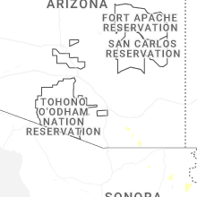
Arizona
| Local Time | Report Details |
|---|---|
| 2:50 PM MST | Half Dollar sized hail reported near Fort Huachuca, AZ, 49.6 miles WNW of Douglas, AZ, half-dollar sized hail reported by fort huachuca. |
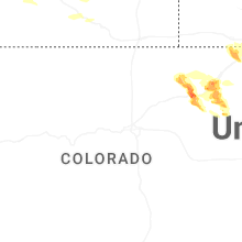
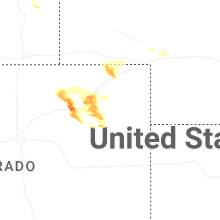
Colorado
| Local Time | Report Details |
|---|---|
| 4:09 PM MDT | Golf Ball sized hail reported near Fort Morgan, CO, 59.2 miles WNW of Yuma, CO, corrects time of previous hail report from 1 nne log lane village. time estimated from radar. |
| 4:14 PM MDT | Golf Ball sized hail reported near Fort Morgan, CO, 57.7 miles W of Yuma, CO, report from mping: golf ball (1.75 in.) time estimated from radar. |
| 4:15 PM MDT | Golf Ball sized hail reported near Fort Morgan, CO, 59.2 miles WNW of Yuma, CO |
| 4:16 PM MDT | Baseball sized hail reported near Fort Morgan, CO, 57.4 miles W of Yuma, CO, numerous reports of golfball to baseball size with considerable damage. |
| 4:18 PM MDT | Hen Egg sized hail reported near Fort Morgan, CO, 57.2 miles W of Yuma, CO, time estimated from radar. |
| 4:18 PM MDT | Tennis Ball sized hail reported near Fort Morgan, CO, 56.7 miles W of Yuma, CO, time estimated from radar. |
| 4:18 PM MDT | Golf Ball sized hail reported near Fort Morgan, CO, 57.2 miles WNW of Yuma, CO |
| 4:26 PM MDT | Storm damage reported in logan county CO, 44.2 miles WNW of Yuma, CO |
| 4:31 PM MDT | Tennis Ball sized hail reported near Fort Morgan, CO, 57.2 miles W of Yuma, CO |
| 4:32 PM MDT | Golf Ball sized hail reported near Trinidad, CO, 74.1 miles S of Pueblo, CO, corrects previous hail report from 3 n cokedale. report indicated shredded tree leaves and broken house windows. |
| 4:33 PM MDT | Quarter sized hail reported near Trinidad, CO, 74.1 miles S of Pueblo, CO |
| 4:41 PM MDT | Hen Egg sized hail reported near Fort Morgan, CO, 56.7 miles W of Yuma, CO, report from mping: hen egg (2.00 in.). |
| 5:02 PM MDT | Golf Ball sized hail reported near Trinidad, CO, 74.1 miles S of Pueblo, CO, report indicated shredded tree leaves and broken house windows. |
| 5:08 PM MDT | Ping Pong Ball sized hail reported near Brush, CO, 46.6 miles W of Yuma, CO, report from mping: ping pong ball (1.50 in.). |
| 5:29 PM MDT | Awos station kako akro in washington county CO, 26.6 miles W of Yuma, CO |
| 5:30 PM MDT | Ping Pong Ball sized hail reported near Woodrow, CO, 39.9 miles WSW of Yuma, CO, time estimated from radar. |
| 5:35 PM MDT | Golf Ball sized hail reported near Akron, CO, 38.9 miles WSW of Yuma, CO, time estimated from radar. |
| 5:38 PM MDT | Storm damage reported in washington county CO, 27 miles W of Yuma, CO |
| 6:12 PM MDT | Quarter sized hail reported near Akron, CO, 32 miles WSW of Yuma, CO, report from mping: quarter (1.00 in.) time estimated from radar. |
| 6:16 PM MDT | Tennis Ball sized hail reported near Iliff, CO, 47.9 miles NNW of Yuma, CO, time and location estimated from radar. |
| 6:16 PM MDT | Ping Pong Ball sized hail reported near Akron, CO, 30.4 miles WSW of Yuma, CO |
| 6:54 PM MDT | Hen Egg sized hail reported near Haxtun, CO, 31.2 miles N of Yuma, CO |
| 7:00 PM MDT | Ping Pong Ball sized hail reported near Haxtun, CO, 31.8 miles N of Yuma, CO |
| 7:00 PM MDT | Tea Cup sized hail reported near Haxtun, CO, 31.8 miles N of Yuma, CO |
| 7:00 PM MDT | Tea Cup sized hail reported near Haxtun, CO, 31.8 miles N of Yuma, CO, corrects previous hail report from 5 s dailey. |
| 7:04 PM MDT | Ping Pong Ball sized hail reported near Haxtun, CO, 28.8 miles N of Yuma, CO |
| 7:47 PM MDT | Ping Pong Ball sized hail reported near Berthoud, CO, 39.7 miles N of Denver, CO |
| 7:47 PM MDT | Ping Pong Ball sized hail reported near Berthoud, CO, 40.4 miles N of Denver, CO |
| 7:52 PM MDT | Golf Ball sized hail reported near Berthoud, CO, 38.9 miles N of Denver, CO |
| 8:26 PM MDT | Quarter sized hail reported near Fort Morgan, CO, 59.5 miles WNW of Yuma, CO |
| 8:46 PM MDT | Golf Ball sized hail reported near Brush, CO, 52.7 miles WNW of Yuma, CO, report from mping: golf ball (1.75 in.). |
| 8:57 PM MDT | Half Dollar sized hail reported near Brush, CO, 48.5 miles WNW of Yuma, CO |
| 11:23 PM MDT | Site 24 & bb on weatherlink measured 62 mph wind gus in yuma county CO, 24.5 miles SE of Yuma, CO |
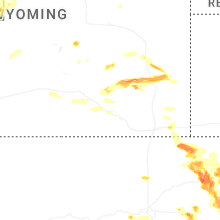
Wyoming
| Local Time | Report Details |
|---|---|
| 4:41 PM MDT | Quarter sized hail reported near Wheatland, WY, 70 miles NNE of Laramie, WY, time estimated from radar imagery. |
| 5:45 PM MDT | Quarter sized hail reported near Rock River, WY, 35 miles NW of Laramie, WY, rock river em reported quarter sized hail in rock river proper. |
| 5:58 PM MDT | Ping Pong Ball sized hail reported near Rock River, WY, 35 miles NW of Laramie, WY, albany county em reported hail sized up to 1.5 inches in rock river. |
| 6:06 PM MDT | Corrects previous non-tstm wnd gst report from 9 wnw elk mountain. mesonet station wy17 8.9 s hanna (wydot in carbon county WY, 58.8 miles WNW of Laramie, WY |
| 6:08 PM MDT | Ping Pong Ball sized hail reported near Yoder, WY, 38.7 miles W of Scottsbluff, NE, trained spotter reported ping pong sized hail stones. |
| 8:22 PM MDT | Quarter sized hail reported near Burns, WY, 56.6 miles E of Laramie, WY |
| 9:02 PM MDT | Quarter sized hail reported near Carpenter, WY, 66.3 miles ESE of Laramie, WY |
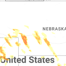
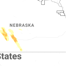
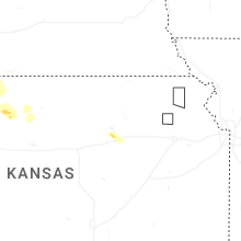
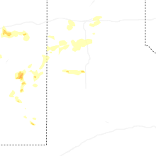
Nebraska
| Local Time | Report Details |
|---|---|
| 6:12 PM MDT | Quarter sized hail reported near Chappell, NE, 68.3 miles N of Yuma, CO, mostly nickels with a few quarters. time estimated from radar. |
| 6:19 PM MDT | Quarter sized hail reported near Ogallala, NE, 46.5 miles W of North Platte, NE, very heavy rain with hail ranging from peas to quarters. time estimated from radar. |
| 6:34 PM MDT | Golf Ball sized hail reported near Ogallala, NE, 52.2 miles W of North Platte, NE, time estimated from radar. |
| 6:42 PM MDT | Golf Ball sized hail reported near Grant, NE, 52.7 miles WSW of North Platte, NE, report relayed from county dispatch and time estimated from radar. |
| 6:55 PM MDT | Tennis Ball sized hail reported near Grant, NE, 50.4 miles WSW of North Platte, NE, report relayed with photos from vfd. time estimated from radar. |
| 7:01 PM MDT | Personal weather statio in perkins county NE, 52.3 miles WSW of North Platte, NE |
| 7:06 PM MDT | Personal weather statio in perkins county NE, 51.4 miles WSW of North Platte, NE |
| 7:10 PM MDT | Relayed report from vfd with photos. tree uprooted and laying on a house. time estimated from rada in perkins county NE, 50 miles WSW of North Platte, NE |
| 7:15 PM MDT | Delayed report. vfd reports multiple pivots overturned in the area. significant building damage from apparent straight line winds. time estimated from rada in perkins county NE, 48.2 miles WSW of North Platte, NE |
| 8:20 PM CDT | Quarter sized hail reported near North Platte, NE, 3.3 miles E of North Platte, NE |
| 7:26 PM MDT | Personal weather statio in perkins county NE, 49.1 miles WSW of North Platte, NE |
| 7:30 PM MDT | Personal weather statio in perkins county NE, 50.1 miles WSW of North Platte, NE |
| 8:30 PM CDT | Hen Egg sized hail reported near North Platte, NE, 6 miles S of North Platte, NE, delayed report with photo via social media. time estimated from radar. |
| 8:36 PM CDT | Quarter sized hail reported near North Platte, NE, 8.5 miles SSE of North Platte, NE, time estimated from radar. |
| 8:37 PM CDT | Report via social media. approximately 7 to 8 power poles snapped along highway 83. video from different report confirms this. time estimated from rada in lincoln county NE, 12.2 miles S of North Platte, NE |
| 8:39 PM CDT | Caller reported 8 inch diameter branch on healthy tree downed. time estimated from rada in lincoln county NE, 11.5 miles S of North Platte, NE |
| 8:39 PM CDT | Quarter sized hail reported near North Platte, NE, 11.5 miles S of North Platte, NE, time estimated from radar. |
| 8:41 PM CDT | Power poles down/broken via mping report. time estimated from rada in lincoln county NE, 12.2 miles S of North Platte, NE |
| 7:55 PM MDT | Baseball sized hail reported near Wauneta, NE, 57.3 miles SSW of North Platte, NE |
| 8:58 PM CDT | Storm damage reported in dawson county NE, 34 miles ESE of North Platte, NE |
| 9:05 PM CDT | Half Dollar sized hail reported near Gothenburg, NE, 34.6 miles ESE of North Platte, NE, report received via facebook. |
| 9:25 PM CDT | Storm damage reported in dawson county NE, 45.2 miles ESE of North Platte, NE |
| 9:39 PM CDT | Storm damage reported in lincoln county NE, 4.4 miles E of North Platte, NE |
| 10:06 PM CDT | Quarter sized hail reported near Elwood, NE, 60.5 miles SE of North Platte, NE, repot received via facebook. |
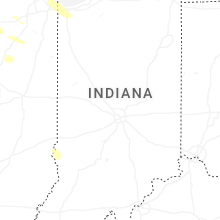
Indiana
| Local Time | Report Details |
|---|---|
| 8:10 PM CDT | Public report of branch downed onto power lines near carolina avenue and 167th street. time estimated by rada in lake county IN, 22.4 miles SSE of Chicago, IL |
| 8:13 PM CDT | Quarter sized hail reported near Highland, IN, 24.7 miles SSE of Chicago, IL, video shared to social media shows dime to quarter size hail near ridge road and 5th street in highland. |
| 8:16 PM CDT | Multiple reports of tree branches downed in highland and griffith. time estimated by rada in lake county IN, 25.1 miles SSE of Chicago, IL |
| 8:18 PM CDT | Photo shared to social media shows large tree uprooted near brinwood drive and arbogast street. time estimated by rada in lake county IN, 26.2 miles SSE of Chicago, IL |
| 8:18 PM CDT | Public reports of branches downed onto indiana street and elmer street. time estimated by rada in lake county IN, 26.8 miles SSE of Chicago, IL |
| 8:19 PM CDT | Large branches downe in lake county IN, 26.4 miles SSE of Chicago, IL |
| 8:19 PM CDT | Public report of multiple branches downed along broad street near main street in griffith. time estimated by rada in lake county IN, 27.2 miles SSE of Chicago, IL |
| 8:20 PM CDT | Multiple public reports of tree branches downed on to ridge road near clark road. time estimated by rada in lake county IN, 26.2 miles SSE of Chicago, IL |
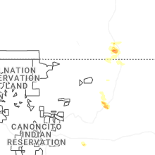
New Mexico
| Local Time | Report Details |
|---|---|
| 7:15 PM MDT | Measured wind gust of 58 mph at wtm 2sw tatum n in lea county NM, 68.7 miles E of Roswell, NM |
| 8:41 PM MDT | Asos station ktcc tucumcari muni airpor in quay county NM, 7.1 miles E of Tucumcari, NM |
Texas
| Local Time | Report Details |
|---|---|
| 10:12 PM CDT | Reports of downed trees and power lines in littlefield. time estimate in lamb county TX, 35.4 miles NW of Lubbock, TX |
| 10:38 PM CDT | Initial severe gust occurred 2 minutes prior with a 59 mph gust at 10:36 pm cd in deaf smith county TX, 46.2 miles ESE of Tucumcari, NM |
| 11:14 PM CDT | Gusts of 58 to 64 mph from 1109 pm to 1116 pm. measured by west texas mesone in parmer county TX, 61.5 miles SW of Amarillo, TX |
| 11:35 PM CDT | Gusts of 58 to 61 mph from 1135 pm to 1140 pm. measured by west texas mesone in castro county TX, 51 miles SSW of Amarillo, TX |
| 11:53 PM CDT | Also gusted to 60 mph at 1154 pm. measured by west texas mesone in castro county TX, 55.8 miles SSW of Amarillo, TX |
| 12:06 AM CDT | Storm damage reported in deaf smith county TX, 36.9 miles SW of Amarillo, TX |
| 12:13 AM CDT | Gusts of 59 to 74 mph from 1207 am to 1219 am. measured by the west texas mesone in swisher county TX, 31.5 miles S of Amarillo, TX |
| 12:25 AM CDT | West texas mesonet measurement at site located 11 miles ne of happ in randall county TX, 26.4 miles SSE of Amarillo, TX |
| 12:29 AM CDT | Gusts of 59 to 67 mph from 1228 am to 1230 am. measured by west texas mesone in swisher county TX, 45.6 miles S of Amarillo, TX |
| 12:32 AM CDT | Also gusted to 62 mph at 1231 am. measured by west texas mesone in swisher county TX, 42.2 miles SSE of Amarillo, TX |
| 12:47 AM CDT | Storm damage reported in potter county TX, 6.5 miles E of Amarillo, TX |
Connect with Interactive Hail Maps