

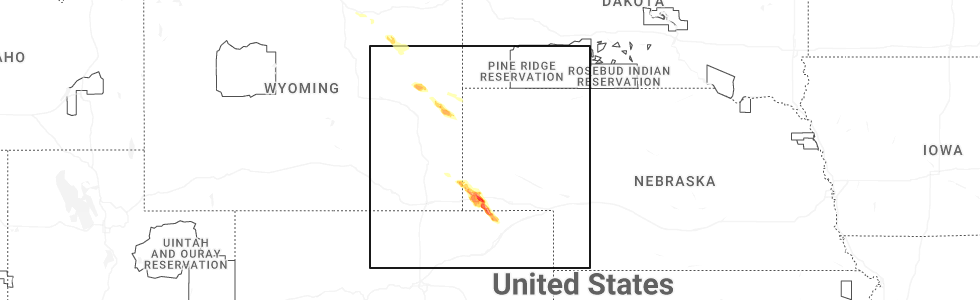
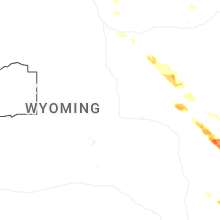
Hail Map for Monday, June 22, 2026
Number of Impacted Households on 6/22/2026
0
Impacted by 1" or Larger Hail
0
Impacted by 1.75" or Larger Hail
0
Impacted by 2.5" or Larger Hail
Square Miles of Populated Area Impacted on 6/22/2026
0
Impacted by 1" or Larger Hail
0
Impacted by 1.75" or Larger Hail
0
Impacted by 2.5" or Larger Hail
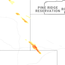
Cities Most Affected by Hail Storms of 6/22/2026
| Hail Size | Demographics of Zip Codes Affected | ||||||
|---|---|---|---|---|---|---|---|
| City | Count | Average | Largest | Pop Density | House Value | Income | Age |
| Kimball, NE | 6 | 2.08 | 2.50 | 7 | $54k | $30.6k | 45.6 |
| Wright, WY | 1 | 1.75 | 1.75 | 0 | $86k | $53.4k | 32.7 |
| Dix, NE | 1 | 1.75 | 1.75 | 1 | $30k | $32.0k | 42.7 |
Hail and Wind Damage Spotted on 6/22/2026
Filter by Report Type:Hail ReportsWind Reports
States Impacted
Arkansas, West Virginia, Mississippi, Pennsylvania, New Jersey, Alabama, Wyoming, Virginia, Tennessee, Nebraska, Colorado, North CarolinaArkansas
| Local Time | Report Details |
|---|---|
| 7:00 AM CDT | A tree down on a house near this location in lama in johnson county AR, 57.2 miles E of Fort Smith, AR |
| 7:09 AM CDT | A report of a tree down on a house in the community of haskell near this locatio in saline county AR, 26.5 miles SW of Little Rock, AR |
| 7:10 AM CDT | Reports of multiple power lines down in russellvill in pope county AR, 59.9 miles NW of Little Rock, AR |
| 7:25 AM CDT | Multiple power outages reported in the vicinity of tyndall park area of bento in saline county AR, 21.7 miles SW of Little Rock, AR |
| 7:26 AM CDT | Reports of a tree blown down on a house near the 1900 block of highway 113... west of morrilton. there were also other trees down in the are in conway county AR, 39.9 miles NW of Little Rock, AR |
| 7:57 AM CDT | A tree blown down blocking southbound lanes of i-530 near white hal in jefferson county AR, 34.3 miles SSE of Little Rock, AR |
| 8:02 AM CDT | A power line was blown down and caught fire along west 24th ave in pine bluf in jefferson county AR, 40.5 miles SSE of Little Rock, AR |
| 8:03 AM CDT | A tree was blown down at the intersection of highway 79 and island harbor marina road in white hal in jefferson county AR, 35.9 miles SSE of Little Rock, AR |
| 8:30 AM CDT | Several large trees were blown down in this are in arkansas county AR, 45 miles ESE of Little Rock, AR |
West Virginia
| Local Time | Report Details |
|---|---|
| 10:32 AM EDT | Tree down on big sandy river road near underpass blocking half the roadway. time estimated from rada in wayne county WV, 51.7 miles W of Charleston, WV |
| 10:45 AM EDT | Trees and power lines down across garretts creek road at cloverleaf lane. time estimated from rada in wayne county WV, 45.3 miles W of Charleston, WV |
| 1:24 PM EDT | Tree down blocking sandy huff road. time estimated from rada in mcdowell county WV, 59.8 miles S of Charleston, WV |
| 1:51 PM EDT | Tree blocking coal river road between horse creek road and peachtree road. time estimated from rada in raleigh county WV, 34.1 miles SSE of Charleston, WV |
| 2:55 PM EDT | Tree down blocking edray road in slippery hill. time estimated from rada in pocahontas county WV, 43.7 miles SSW of Elkins, WV |
| 3:04 PM EDT | Tree down. wire and power pole also on ground. road is blocke in greenbrier county WV, 39.6 miles NW of Roanoke, VA |
| 3:17 PM EDT | Tree and power line dow in greenbrier county WV, 44.6 miles NNW of Roanoke, VA |
Mississippi
| Local Time | Report Details |
|---|---|
| 10:50 AM CDT | Lines down and power ou in sunflower county MS, 100.8 miles NNW of Jackson, MS |
| 12:00 PM CDT | Lines down and multiple areas of power outage in hinds county MS, 5 miles NNW of Jackson, MS |
| 12:43 PM CDT | Tree down on old hwy 2 in warren county MS, 37.5 miles W of Jackson, MS |
| 1:00 PM CDT | Line down and power outage in madison county MS, 22.9 miles N of Jackson, MS |
| 1:00 PM CDT | Tree down in tow in attala county MS, 53 miles WSW of Starkville, MS |
| 1:03 PM CDT | Tree down along hwy 35 in attala county MS, 53.5 miles SW of Starkville, MS |
| 1:18 PM CDT | Tree down along hwy 48 in newton county MS, 53.2 miles E of Jackson, MS |
| 1:28 PM CDT | Tree dow in newton county MS, 55.1 miles E of Jackson, MS |
| 1:42 PM CDT | Tree and lines down on hight moore r in winston county MS, 37.7 miles SSW of Starkville, MS |
Pennsylvania
| Local Time | Report Details |
|---|---|
| 2:24 PM EDT | Multiple large tree branches and a tree snapped. time estimated from rada in philadelphia county PA, 71 miles SW of Brooklyn, NY |
| 4:52 PM EDT | Quarter sized hail reported near Chester Springs, PA, 74.3 miles NE of Baltimore, MD, report from mping: quarter (1.00 in.). |
| 9:18 PM UTC | Multiple large tree branches snapped near the intersection of newark road and clonmell mill road. a tree is also down on newark road. time estimated from rada in chester county PA, 61 miles NE of Baltimore, MD |
| 5:20 PM EDT | Multiple reports of wires down along clayton road. time estimated from rada in chester county PA, 67.3 miles NE of Baltimore, MD |
| 9:20 PM UTC | Trees and power lines down. the power lines are smoking. ham-ares southwest pa. time estimated via rada in fayette county PA, 32 miles SE of Pittsburgh, PA |
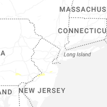
New Jersey
| Local Time | Report Details |
|---|---|
| 2:48 PM EDT | Half Dollar sized hail reported near Burlington, NJ, 60.5 miles SW of Brooklyn, NY, trained spotter reports a lot of pea sized hail... but a few hailstones up to half dollar sized. time estimated from radar. |
| 2:48 PM EDT | Quarter sized hail reported near Burlington, NJ, 60.5 miles SW of Brooklyn, NY, a trained spotter shared a photo of quarter sized hail. time estimated from radar. |
| 2:48 PM EDT | Ping Pong Ball sized hail reported near Burlington, NJ, 60 miles SW of Brooklyn, NY, 2 minutes of hail up to 1.5 inch diameter. time estimated from radar. |
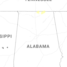
Alabama
| Local Time | Report Details |
|---|---|
| 2:27 PM CDT | Tree down on county road 2 west of county road 4. time estimated from rada in lauderdale county AL, 8.3 miles W of Florence, AL |
| 2:40 PM CDT | Trees down on power line on cr 49 in jackson county AL, 21.5 miles WSW of Chattanooga, TN |
| 2:54 PM CDT | Trees down on power lines on county road 77 at guffey roa in jackson county AL, 57.5 miles SW of Chattanooga, TN |
| 2:54 PM CDT | Tree down on county road 78 at cr 34 in jackson county AL, 33.7 miles SW of Chattanooga, TN |
| 2:56 PM CDT | Tree down blocking both lanes on county road 76 near the intersection of cr 55... cr 51... and cr 76. time estimated from rada in lauderdale county AL, 20.6 miles ENE of Florence, AL |
| 3:03 PM CDT | Tree down on the road near county road 50 and 51. time estimated from rada in lauderdale county AL, 21.6 miles ENE of Florence, AL |
| 3:35 PM CDT | Tree down - i65 southbound... just south of buccee in limestone county AL, 42.9 miles E of Florence, AL |
| 3:40 PM CDT | Tree and powerlines dow in madison county AL, 53.3 miles E of Florence, AL |
| 3:51 PM CDT | Powerlines dow in madison county AL, 60.7 miles E of Florence, AL |
| 8:53 PM UTC | Powerlines dow in madison county AL, 64.8 miles E of Florence, AL |
| 3:53 PM CDT | Tree dow in madison county AL, 57.8 miles E of Florence, AL |
| 3:56 PM CDT | Powerlines dow in madison county AL, 63 miles E of Florence, AL |
| 8:56 PM UTC | Tree down near moores mill fire station on moores mill r in madison county AL, 65.7 miles E of Florence, AL |
| 3:57 PM CDT | Trees down near intersection of moores mill and riverside d in madison county AL, 65.7 miles E of Florence, AL |
| 8:58 PM UTC | Powerlines dow in madison county AL, 67 miles W of Chattanooga, TN |
| 4:03 PM CDT | Large tree branches dow in madison county AL, 67.4 miles E of Florence, AL |
| 9:04 PM UTC | Powerlines dow in madison county AL, 64.3 miles W of Chattanooga, TN |
| 4:35 PM CDT | Power poles leaning across roadwa in madison county AL, 60.6 miles E of Florence, AL |
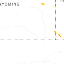
Wyoming
| Local Time | Report Details |
|---|---|
| 1:39 PM MDT | Quarter sized hail reported near Albin, WY, 34.7 miles SW of Scottsbluff, NE |
| 2:44 PM MDT | Storm damage reported in campbell county WY, 35 miles SW of Gillette, WY |
| 2:47 PM MDT | Quarter sized hail reported near Van Tassell, WY, 69 miles NNW of Scottsbluff, NE |
| 3:18 PM MDT | Quarter sized hail reported near Lusk, WY, 76.3 miles NW of Scottsbluff, NE |
| 9:23 PM UTC | Golf Ball sized hail reported near Wright, WY, 39 miles S of Gillette, WY, reported along highway 387. emergency manager reports no damage in wright. |
| 3:25 PM MDT | Ping Pong Ball sized hail reported near Wright, WY, 37.5 miles S of Gillette, WY |
| 9:47 PM UTC | Quarter sized hail reported near Lusk, WY, 65.9 miles NW of Scottsbluff, NE |
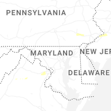
Virginia
| Local Time | Report Details |
|---|---|
| 3:49 PM EDT | Trees down on mill creek road in page county VA, 75.9 miles ESE of Elkins, WV |
| 4:19 PM EDT | Trees down sperryville pike (us-522 in rappahannock county VA, 83.9 miles NNW of Richmond, VA |
| 5:04 PM EDT | Numerous trees down in vicinity of pond spice lane and heron pond terrace. siding and shingle damage as wel in fairfax county VA, 50.7 miles SW of Baltimore, MD |
| 9:35 PM UTC | Large branches and trees down in kents store area. time estimated by rada in fluvanna county VA, 36.9 miles NW of Richmond, VA |
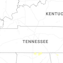
Tennessee
| Local Time | Report Details |
|---|---|
| 3:57 PM EDT | Tree(s) reported down on campbell st. timing based on rada in hamilton county TN, 4.3 miles ENE of Chattanooga, TN |
Nebraska
| Local Time | Report Details |
|---|---|
| 2:24 PM MDT | Golf Ball sized hail reported near Kimball, NE, 39 miles S of Scottsbluff, NE |
| 2:44 PM MDT | Golf Ball sized hail reported near Kimball, NE, 43 miles S of Scottsbluff, NE, reports of 1-2 inches of hail on the ground. |
| 2:44 PM MDT | Hen Egg sized hail reported near Kimball, NE, 43 miles S of Scottsbluff, NE, corrects previous hail report from 2 w kimball. reports of 1-2 inches of hail on the ground. |
| 2:52 PM MDT | Tennis Ball sized hail reported near Kimball, NE, 43 miles S of Scottsbluff, NE, car windows busted. |
| 3:00 PM MDT | Quarter sized hail reported near Kimball, NE, 43.6 miles S of Scottsbluff, NE |
| 3:03 PM MDT | Tennis Ball sized hail reported near Kimball, NE, 41.7 miles S of Scottsbluff, NE, picture report via social media from a meteorologist and trained spotter. |
| 3:13 PM MDT | Ping Pong Ball sized hail reported near Kimball, NE, 51.9 miles S of Scottsbluff, NE |
| 3:13 PM MDT | Half Dollar sized hail reported near Kimball, NE, 49.8 miles S of Scottsbluff, NE, report from mping: half dollar (1.25 in.). |
| 3:28 PM MDT | Golf Ball sized hail reported near Dix, NE, 54.2 miles S of Scottsbluff, NE |
| 10:05 PM UTC | Hen Egg sized hail reported near Kimball, NE, 56.7 miles S of Scottsbluff, NE, trained spotter reported 2 inch hail falling out of core on hwy 71. |
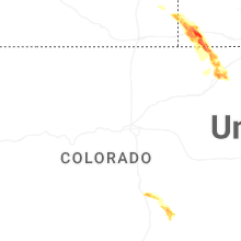
Colorado
| Local Time | Report Details |
|---|---|
| 3:07 PM MDT | Quarter sized hail reported near Fountain, CO, 31.8 miles N of Pueblo, CO |
| 3:15 PM MDT | Quarter sized hail reported near Fountain, CO, 29.6 miles N of Pueblo, CO |
| 3:18 PM MDT | Ping Pong Ball sized hail reported near Fountain, CO, 31.8 miles N of Pueblo, CO |
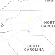
North Carolina
| Local Time | Report Details |
|---|---|
| 9:24 PM UTC | Power lines down along highway 16 north a few miles from the wilkes/alexander county lin in alexander county NC, 58.5 miles NNW of Charlotte, NC |
| 9:27 PM UTC | A large tree was blown down by thunderstorm winds near the intersection of brookfall dairy road and poplar springs roa in surry county NC, 73.6 miles N of Charlotte, NC |
| 9:27 PM UTC | A large tree was blown down by thunderstorm winds along ebenezer church roa in surry county NC, 73.6 miles N of Charlotte, NC |
| 9:32 PM UTC | A power line was blown down by thunderstorms winds along newsome street in the community of mount air in surry county NC, 65.7 miles SW of Roanoke, VA |
| 9:32 PM UTC | A large tree was blown down by thunderstorm winds near the intersection of cc camp road and still meadows lan in surry county NC, 73 miles N of Charlotte, NC |
| 9:33 PM UTC | A power line was blown down by thunderstorm winds along bronco trai in surry county NC, 75 miles N of Charlotte, NC |
| 9:37 PM UTC | A power line was blown down by thunderstorm winds along highway 60 in surry county NC, 76.6 miles N of Charlotte, NC |
| 9:38 PM UTC | A large tree was blown down by thunderstorm winds near the intersection of highway 268 and bear creek church roa in surry county NC, 76.6 miles N of Charlotte, NC |
| 9:38 PM UTC | A large tree was blown down by thunderstorm winds near the intersection of highway 268 and chariot lan in surry county NC, 76.6 miles N of Charlotte, NC |
| 9:54 PM UTC | A large tree was blown down by thunderstorm winds along pilot church roa in surry county NC, 73.1 miles SSW of Roanoke, VA |
Connect with Interactive Hail Maps