

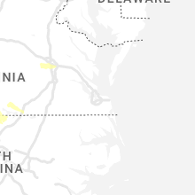
Hail Map for Tuesday, May 16, 2023

Number of Impacted Households on 5/16/2023
0
Impacted by 1" or Larger Hail
0
Impacted by 1.75" or Larger Hail
0
Impacted by 2.5" or Larger Hail
Square Miles of Populated Area Impacted on 5/16/2023
0
Impacted by 1" or Larger Hail
0
Impacted by 1.75" or Larger Hail
0
Impacted by 2.5" or Larger Hail


Cities Most Affected by Hail Storms of 5/16/2023
| Hail Size | Demographics of Zip Codes Affected | ||||||
|---|---|---|---|---|---|---|---|
| City | Count | Average | Largest | Pop Density | House Value | Income | Age |
| Kimper, KY | 2 | 1.75 | 1.75 | 48 | $68k | $24.5k | 38.8 |
| Raccoon, KY | 1 | 2.50 | 2.50 | 74 | $65k | $28.2k | 40.3 |
| Hazard, KY | 1 | 1.75 | 1.75 | 92 | $60k | $22.6k | 40.2 |
| Clay City, KY | 1 | 1.75 | 1.75 | 93 | $57k | $23.0k | 37.7 |
| Casar, NC | 1 | 1.75 | 1.75 | 54 | $68k | $33.8k | 43.5 |
Hail and Wind Damage Spotted on 5/16/2023
Filter by Report Type:Hail ReportsWind Reports
States Impacted
Kentucky, Alabama, Mississippi, Tennessee, Virginia, Texas, Georgia, South Carolina, Oregon, North Carolina, West Virginia, Nebraska, Kansas, MontanaKentucky
| Local Time | Report Details |
|---|---|
| 12:25 PM CDT | Delayed report: dispatch reported tree down on raider hallow r in hart county KY, 43.9 miles SSW of Louisville, KY |
| 2:10 PM EDT | Trees down across from marion county public librar in marion county KY, 38.5 miles SE of Louisville, KY |
| 2:18 PM EDT | Tree down on a power line on tatum lan in marion county KY, 43.1 miles SE of Louisville, KY |
| 1:22 PM CDT | A tree fell across 31 east near un in hart county KY, 56.1 miles S of Louisville, KY |
| 1:32 PM CDT | Dead tree came down on his driveway. time estimated from rada in russell county KY, 77.8 miles SW of Irvine, KY |
| 2:33 PM EDT | Trees down in the forkland are in boyle county KY, 50.4 miles SE of Louisville, KY |
| 2:41 PM EDT | Received two reports of a tree down on red house roa in madison county KY, 18.5 miles WNW of Irvine, KY |
| 2:44 PM EDT | Tree down on the 10000 block of highway 78 wes in lincoln county KY, 49 miles WSW of Irvine, KY |
| 2:44 PM EDT | Tree down on southridge r in lincoln county KY, 47.5 miles WSW of Irvine, KY |
| 2:53 PM EDT | Tree down on highway 69 in lincoln county KY, 41.6 miles WSW of Irvine, KY |
| 2:55 PM EDT | Tree and power line down on danville avenue between portman avenue and maxwell stree in lincoln county KY, 39.9 miles WSW of Irvine, KY |
| 2:59 PM EDT | Tree down on horton cutoff roa in lincoln county KY, 35.7 miles WSW of Irvine, KY |
| 3:00 PM EDT | Tree down on the 9000 block of us 12 in casey county KY, 64.8 miles WSW of Irvine, KY |
| 3:03 PM EDT | Tree down on river driv in casey county KY, 66.1 miles SE of Louisville, KY |
| 3:07 PM EDT | Tree down on the 9000 block of kentucky 124 in lincoln county KY, 42.3 miles WSW of Irvine, KY |
| 2:09 PM CDT | Large limb was blocking the intersection at liberty road and bull run road. the road department was dispatched to remove the lim in adair county KY, 64.9 miles SSE of Louisville, KY |
| 3:09 PM EDT | Tree down along highway 3245 about a half mile west of the u.s. 150 intersection. time estimated from rada in rockcastle county KY, 33.7 miles SW of Irvine, KY |
| 3:10 PM EDT | Tree down on a vehicle at 142 proffitt street. time estimated from rada in rockcastle county KY, 32 miles SW of Irvine, KY |
| 3:10 PM EDT | Tree down in broadhead along highway 1505. time estimated from rada in rockcastle county KY, 31.6 miles SW of Irvine, KY |
| 3:11 PM EDT | Tree down along highway 1505 near the intersection of highway 1326. time estimated from rada in rockcastle county KY, 31.2 miles SW of Irvine, KY |
| 3:12 PM EDT | Multiple trees down at 1490 barnett road. time estimated from rada in rockcastle county KY, 30 miles SW of Irvine, KY |
| 3:12 PM EDT | Golf Ball sized hail reported near Clay City, KY, 7.8 miles NNE of Irvine, KY, picture on social media shows hail up golf-ball size near vaughn mill. |
| 3:13 PM EDT | Tree down on a powerline off of koa campground road. time estimated from rada in rockcastle county KY, 28.4 miles SW of Irvine, KY |
| 3:13 PM EDT | Tree down on red bird road near lake linville road. time estimated from rada in rockcastle county KY, 29.2 miles SW of Irvine, KY |
| 3:15 PM EDT | Quarter sized hail reported near Clay City, KY, 9 miles NNE of Irvine, KY, nickel to quarter-sized hail covering the ground. |
| 3:24 PM EDT | Corrects previous tstm wnd dmg report from 2 s science hill. report of a tree down on a powerline off of highway 1247 near the intersection of raleigh road. time estima in pulaski county KY, 52.3 miles SW of Irvine, KY |
| 3:25 PM EDT | Tree down off of nelson valley road near the intersection of jeffries drive. time estimated from rada in pulaski county KY, 51.2 miles SW of Irvine, KY |
| 3:28 PM EDT | Powerline down on bourne avenue close to the intersection of murphy avenue. time estimated from rada in pulaski county KY, 55.2 miles SW of Irvine, KY |
| 3:29 PM EDT | A tree was reported down on ky 3403 near the harlan county line in the vicinity of partridge. the time of the event is radar estimate in letcher county KY, 47 miles NW of Bristol, TN |
| 3:32 PM EDT | Corrects previous tstm wnd dmg report from lewis creek. a tree was reported down on ky 3403 near the harlan county line in the vicinity of partridge. the time of the ev in letcher county KY, 47 miles NW of Bristol, TN |
| 3:45 PM EDT | Tree down near the 2000 block of old whitney road. time estimated from rada in pulaski county KY, 54.3 miles SSW of Irvine, KY |
| 3:45 PM EDT | Tree down along highway 30. time estimated from rada in breathitt county KY, 44.2 miles E of Irvine, KY |
| 3:49 PM EDT | 2 trees down along highway 30. time estimated from rada in breathitt county KY, 44.5 miles E of Irvine, KY |
| 3:51 PM EDT | A tree was blown down on north laurel road just north of the london city limit in laurel county KY, 38.6 miles S of Irvine, KY |
| 3:52 PM EDT | A tree was reported to have been blown down in east bernstadt. the time of the event is radar estimate in laurel county KY, 36.1 miles SSW of Irvine, KY |
| 4:10 PM EDT | Trees and large limbs were reported to have been blown down on marydell road near bus in laurel county KY, 42.3 miles S of Irvine, KY |
| 4:20 PM EDT | Half Dollar sized hail reported near Bonnyman, KY, 51.3 miles ESE of Irvine, KY, picture posted to social media shows approximately half dollar-sized hail at hazard animal shelter. time estimated from radar. |
| 4:23 PM EDT | A tree was reported down on ky hwy 777 near the kentucky hydrocarbon company plan in floyd county KY, 65.5 miles E of Irvine, KY |
| 4:25 PM EDT | Golf Ball sized hail reported near Hazard, KY, 55.1 miles ESE of Irvine, KY, picture on social media show approximately golf-ball size hail south of fisty... ky. time estimated from radar. |
| 4:42 PM EDT | Trees were reported to have been blown down on ky 108 in knott county KY, 60.2 miles ESE of Irvine, KY |
| 4:52 PM EDT | A tree was reported to have been downed along ky 522 near russell road. the time of the event is radar estimate in harlan county KY, 61.4 miles WNW of Bristol, TN |
| 4:55 PM EDT | A tree was reported to have been blown down on ky 1469 near the pike county line. the time of the event is radar estimate in letcher county KY, 52.8 miles NNW of Bristol, TN |
| 4:58 PM EDT | A tree was reported to have been blown down in mcroberts. the time of the event is radar estimate in letcher county KY, 49.3 miles NNW of Bristol, TN |
| 5:00 PM EDT | Several trees were reported to have bene blown down onto ky 3409 between jenkins and mcroberts. the time of the event is radar estimate in letcher county KY, 48.2 miles NNW of Bristol, TN |
| 5:00 PM EDT | A tree was downed onto ky hwy 3001 near the harlan country club. the time of the event is radar estimate in harlan county KY, 60 miles WNW of Bristol, TN |
| 5:00 PM EDT | A tree was blown down onto ky hwy 1556. the time of the event is radar estimate in harlan county KY, 59.1 miles WNW of Bristol, TN |
| 5:01 PM EDT | Tennis Ball sized hail reported near Raccoon, KY, 64.9 miles N of Bristol, TN, report of video provided to pike county em. at least tennis ball size hail. time estimated from radar. |
| 5:02 PM EDT | A tree was reported to have been blown down onto ky 3001 near mountain oaks drive. the time of the event is radar estimate in harlan county KY, 59.3 miles WNW of Bristol, TN |
| 5:02 PM EDT | A tree was reported to have been blown down onto ky hwy 987 near martins fork lake. the time of the event is radar estimate in harlan county KY, 58.6 miles W of Bristol, TN |
| 5:05 PM EDT | A tree was reported to have been blown down onto ky hwy 805 near big shelby creek roa in pike county KY, 47.2 miles NNW of Bristol, TN |
| 5:05 PM EDT | A tree was blown down onto ky highway 805 about 1 to 2 miles from the pike county line. the time of the event is radar estimate in letcher county KY, 46 miles NNW of Bristol, TN |
| 5:05 PM EDT | Report from mping: large limbs were blown dow in letcher county KY, 49.9 miles NNW of Bristol, TN |
| 5:08 PM EDT | A tree was reported to have been blown down on ky hwy 302 between on half mile and one mile before dewey da in floyd county KY, 68.2 miles E of Irvine, KY |
| 5:09 PM EDT | Golf Ball sized hail reported near Kimper, KY, 65.4 miles N of Bristol, TN, report forwarded via twitter off of lawsons branch near highway 194. |
| 5:09 PM EDT | A tree was reported down near 1106 ky highway 568 near cranks. the event time is radar estimate in harlan county KY, 53.7 miles WNW of Bristol, TN |
| 5:10 PM EDT | Golf Ball sized hail reported near Kimper, KY, 63 miles N of Bristol, TN, video provided to pike county em showed golf ball size hail. time estimated from radar. |
| 5:13 PM EDT | Pike county em referred to dispatch for reports of trees down in southern pike county. time estimated from rada in pike county KY, 47.8 miles NNW of Bristol, TN |
| 5:15 PM EDT | A tree was blown down onto old us 119 at partridge. the time of the event is radar estimate in letcher county KY, 47.4 miles NW of Bristol, TN |
Alabama
| Local Time | Report Details |
|---|---|
| 1:18 PM CDT | Large oak trees uprooted in mood in st. clair county AL, 22.4 miles ENE of Birmingham, AL |
| 1:22 PM CDT | Tree fell through the roof of a residence. no injuries reporte in jefferson county AL, 6.7 miles SE of Birmingham, AL |
| 1:33 PM CDT | Trees reported down in leed in jefferson county AL, 15.2 miles E of Birmingham, AL |
| 2:40 PM CDT | Fences and awnings blown down along county road 36. radar showed a microburst at this locatio in dale county AL, 78.4 miles S of Auburn, AL |
| 2:42 PM CDT | Trees down in numerous locations throughout talladega county. roadways blocked in several location in talladega county AL, 41.5 miles E of Birmingham, AL |
| 4:37 PM CDT | Multiple reports of downed trees along highway 20 and highway 22 between phil campbell and russellville. specific time of event based on radar dat in franklin county AL, 28.5 miles S of Florence, AL |
| 5:21 PM CDT | Section of roof blown off an outbuilding/barn-like structur in walker county AL, 50.7 miles NW of Birmingham, AL |
| 5:43 PM CDT | A large pine tree was uprooted near the intersection of cr 52 and cr 89 to the northwest of anderson. specific time of event based on radar dat in lauderdale county AL, 23.9 miles ENE of Florence, AL |
| 5:54 PM CDT | Limestone county ema director estimated a wind gust of at least 60 mph at this location. specific time of event based on radar dat in limestone county AL, 50 miles E of Florence, AL |
| 5:55 PM CDT | Power lines were blown down near the intersection of cr 58 and county line rd. along the lauderdale-limestone county border. specific time of event based on radar dat in limestone county AL, 29.2 miles ENE of Florence, AL |
| 5:55 PM CDT | Trees and power lines were blow down near the intersection of garrison rd. and targum rd. in hartselle... with reports relayed from ema and broadcast media. specific ti in morgan county AL, 43.5 miles ESE of Florence, AL |
Mississippi
| Local Time | Report Details |
|---|---|
| 2:23 PM CDT | Law enforcement reported several trees down near hwy 50 in jasper county MS, 68.4 miles E of Jackson, MS |
Tennessee
| Local Time | Report Details |
|---|---|
| 3:50 PM EDT | Quarter sized hail reported near Knoxville, TN, 10 miles NNE of Knoxville, TN, report from mping: quarter (1.00 in.). |
| 4:03 PM EDT | Quarter sized hail reported near Corryton, TN, 14.8 miles NE of Knoxville, TN, 1 inch hail in corryton... tn. time estimated from radar. |
| 4:20 PM EDT | Trees and large tree limbs down in and near seven oaks subdivisio in hamblen county TN, 33.5 miles ENE of Knoxville, TN |
| 5:00 PM EDT | 3 trees down. one tree on top of ca in knox county TN, 3.6 miles WNW of Knoxville, TN |
| 5:30 PM EDT | Quarter sized hail reported near Knoxville, TN, 4.1 miles N of Knoxville, TN |
| 5:35 PM EDT | Trees dow in campbell county TN, 31.8 miles NNW of Knoxville, TN |
| 5:45 PM EDT | Numerous trees dow in sevier county TN, 19.7 miles ESE of Knoxville, TN |
| 6:15 PM EDT | Tree dewon in rutledg in grainger county TN, 31 miles NE of Knoxville, TN |
| 6:15 PM EDT | Report from mping: 3-inch tree limbs broken; power poles broke in grainger county TN, 26.3 miles NE of Knoxville, TN |
| 6:35 PM EDT | Few trees dow in anderson county TN, 21.2 miles W of Knoxville, TN |
| 6:35 PM EDT | Multiple trees dow in johnson county TN, 16.9 miles ESE of Bristol, TN |
| 6:40 PM EDT | Few trees dow in hamblen county TN, 34 miles ENE of Knoxville, TN |
| 6:50 PM EDT | Few trees and power lines dow in bradley county TN, 26.5 miles ENE of Chattanooga, TN |
| 5:54 PM CDT | Broadcast media relayed viewer report of a tree blown down. specific location and time of event were based on radar dat in lincoln county TN, 63 miles W of Chattanooga, TN |
| 7:03 PM EDT | Multiple trees dow in polk county TN, 37.4 miles ENE of Chattanooga, TN |
| 7:10 PM EDT | Trees down across roadwa in polk county TN, 36.7 miles ENE of Chattanooga, TN |
| 7:25 PM EDT | Several trees dow in knox county TN, 3 miles NNE of Knoxville, TN |
Virginia
| Local Time | Report Details |
|---|---|
| 4:14 PM EDT | Thunderstorm winds blew down a tree on rockwood park road right before hickory hill driv in henry county VA, 31.8 miles S of Roanoke, VA |
| 4:27 PM EDT | Quarter sized hail reported near Axton, VA, 38.1 miles SSE of Roanoke, VA, reported by citizen on mt. vernon road. |
| 4:41 PM EDT | Tree down on dillions fork road... near the ramp to u.s. highway 22 in henry county VA, 39.4 miles S of Roanoke, VA |
| 4:51 PM EDT | Tree down on house on waller lan in pittsylvania county VA, 46.6 miles SSE of Roanoke, VA |
| 4:56 PM EDT | Two trees snapped by thunderstorm winds near the intersection of peppers ferry road and va route 61 in wythe county VA, 55.7 miles WSW of Roanoke, VA |
| 5:08 PM EDT | Multiple trees down in ringgold area... including ringgold depot rd.... oliver dr.... and gunn garland r in pittsylvania county VA, 57.8 miles SE of Roanoke, VA |
| 5:14 PM EDT | Tree down along the lake road and marina c in dickenson county VA, 43.4 miles N of Bristol, TN |
| 5:15 PM EDT | Trees dow in wise county VA, 33.3 miles NW of Bristol, TN |
| 5:16 PM EDT | Tree down on miami lane in clintwoo in dickenson county VA, 41.5 miles NNW of Bristol, TN |
| 5:17 PM EDT | Tree down on dc truck stop roa in dickenson county VA, 41.3 miles N of Bristol, TN |
| 5:19 PM EDT | Tree down along centennial heights roa in dickenson county VA, 42.9 miles N of Bristol, TN |
| 5:22 PM EDT | Tree down along newberry ridge and big ridge roa in dickenson county VA, 41.9 miles N of Bristol, TN |
| 5:22 PM EDT | Tree down along the lake road and dwale lane in clintwoo in dickenson county VA, 42.5 miles NNW of Bristol, TN |
| 5:23 PM EDT | Tree down at 212 dc truck stop road in clinch in dickenson county VA, 43.4 miles N of Bristol, TN |
| 5:24 PM EDT | Trees down along bartlick road and little rockhouse roa in dickenson county VA, 44.2 miles N of Bristol, TN |
| 5:24 PM EDT | Trees down all over vicey mountain road and 4 trees down on a hous in dickenson county VA, 43.3 miles N of Bristol, TN |
| 5:25 PM EDT | Multiple trees dow in lee county VA, 46.4 miles WNW of Bristol, TN |
| 5:25 PM EDT | Trees and power lines down on doe branc in dickenson county VA, 42.7 miles N of Bristol, TN |
| 5:30 PM EDT | Trees dow in scott county VA, 33.3 miles WNW of Bristol, TN |
| 5:33 PM EDT | Tree down along gc powers driv in dickenson county VA, 42.9 miles N of Bristol, TN |
| 5:33 PM EDT | Thunderstorm winds blew down one tree on to a power line along westover driv in city of danville county VA, 53.4 miles SSE of Roanoke, VA |
| 5:38 PM EDT | Tree down along robinson fork road in the area of garden cree in buchanan county VA, 39.6 miles NNE of Bristol, TN |
| 5:40 PM EDT | Tree down and water line buste in dickenson county VA, 44.7 miles NNW of Bristol, TN |
| 5:40 PM EDT | *** 1 fatal *** tree fell onto an occupied vehicle on welcome lan in dickenson county VA, 43.4 miles N of Bristol, TN |
| 5:45 PM EDT | Tree down along old stone drive. tree has fallen on a house and its hug in dickenson county VA, 44.6 miles NNW of Bristol, TN |
| 5:49 PM EDT | Tree down on a vehicle in a driveway along pat field road in hays in dickenson county VA, 44.3 miles N of Bristol, TN |
| 5:50 PM EDT | Multiple trees dow in russell county VA, 30.8 miles NNE of Bristol, TN |
| 5:50 PM EDT | One tree was blown down in red as in tazewell county VA, 40.7 miles NNE of Bristol, TN |
| 6:03 PM EDT | One tree down across earls branch roa in tazewell county VA, 46.9 miles NE of Bristol, TN |
| 6:30 PM EDT | Couple of large trees down along route 107 in saltvill in smyth county VA, 32.8 miles NE of Bristol, TN |
| 6:35 PM EDT | Couple of large trees down along allison gap roa in smyth county VA, 32.8 miles NE of Bristol, TN |
| 6:42 PM EDT | Large tree fell on hous in smyth county VA, 42.3 miles ENE of Bristol, TN |
| 6:43 PM EDT | Large tree dow in smyth county VA, 42.5 miles ENE of Bristol, TN |
| 6:45 PM EDT | Large tree dow in smyth county VA, 42.5 miles ENE of Bristol, TN |
| 6:46 PM EDT | One tree down on figsboro roa in henry county VA, 33.6 miles S of Roanoke, VA |
| 6:55 PM EDT | Flag pole broken. large limbs and three trees downed. trampoline blown in neighbors tree 500 yards awa in wythe county VA, 62.1 miles WSW of Roanoke, VA |
| 7:15 PM EDT | 15 inch diameter trees down at the intersect of meadowlark road and declaration lan in carroll county VA, 65 miles WSW of Roanoke, VA |
| 7:18 PM EDT | Half Dollar sized hail reported near Stuart, VA, 52.3 miles SSW of Roanoke, VA |
| 7:30 PM EDT | The franklin county sheriffs department reported numerous trees down across the county... as well as many power outages. many of the reports were received after 7:30 pm in franklin county VA, 19 miles S of Roanoke, VA |
| 7:33 PM EDT | Several trees were blown down in multiple locations around the community of meadows of da in patrick county VA, 45.8 miles SW of Roanoke, VA |
| 7:41 PM EDT | Thunderstorm winds blew down one tree onto forestdale driv in city of danville county VA, 54.6 miles SE of Roanoke, VA |
| 7:47 PM EDT | Large tree down on a roof of a house and another tree fell onto a large propane tan in pittsylvania county VA, 57.8 miles SE of Roanoke, VA |
| 7:47 PM EDT | Thunderstorm winds blew down about twenty trees along ringgold church road from the barker road intersection to the countryside drive intersectio in pittsylvania county VA, 57.2 miles SE of Roanoke, VA |
| 7:51 PM EDT | One tree down on willie craig roa in henry county VA, 35.6 miles S of Roanoke, VA |
| 7:54 PM EDT | Numerous trees were blown down near the intersection of jeb stuart highway and trot valley road. a nearby personal weather station recorded a 52 mph wind gust at the ti in patrick county VA, 43.9 miles SSW of Roanoke, VA |
| 7:58 PM EDT | Several trees were blown down in multiple locations around the town of stuar in patrick county VA, 48.1 miles SSW of Roanoke, VA |
| 7:58 PM EDT | A few downed tree in henry county VA, 36 miles S of Roanoke, VA |
| 8:00 PM EDT | Numerous trees were reported down around the bassett area of henry count in henry county VA, 35.4 miles S of Roanoke, VA |
| 8:06 PM EDT | One tree down on chatham roa in henry county VA, 38.9 miles SSE of Roanoke, VA |
| 8:25 PM EDT | Thunderstorm winds blew down three trees near the intersection of izaak walton road and blue ridge driv in pittsylvania county VA, 38.6 miles ESE of Roanoke, VA |
| 9:35 PM EDT | Quarter sized hail reported near Richmond, VA, 7.6 miles ESE of Richmond, VA, one inch hail reported in north chesterfield. time estimated from radar. |
| 9:35 PM EDT | Trees and powerpoles knocked down along avignon drive. time estimated from rada in chesterfield county VA, 5.9 miles ENE of Richmond, VA |
| 9:37 PM EDT | Tree knocked down along middlefield ct. time estimated from rada in chesterfield county VA, 7.9 miles SE of Richmond, VA |
Texas
| Local Time | Report Details |
|---|---|
| 3:16 PM CDT | Large tree limb downe in galveston county TX, 27.4 miles SE of Houston, TX |
| 6:01 PM CDT | Bush intercontinental asos station reported 58 mph wind gus in harris county TX, 15.9 miles N of Houston, TX |
Georgia
| Local Time | Report Details |
|---|---|
| 4:37 PM EDT | Tree down along macedonia church r in haralson county GA, 46.6 miles W of Atlanta, GA |
| 4:48 PM EDT | Tree down along hwy 78 in the town of wac in haralson county GA, 45.5 miles W of Atlanta, GA |
South Carolina
| Local Time | Report Details |
|---|---|
| 4:39 PM EDT | Corrects time of previous tstm wnd dmg report from 3 s seneca. a fallen tree was reported at the intersection of campbell bridge road and wild fern roa in oconee county SC, 23.9 miles WSW of Greenville, SC |
| 4:40 PM EDT | Corrects time of previous tstm wnd dmg report from 3 sse seneca. a fallen tree reported at the intersection of bent tree drive and friendship roa in oconee county SC, 23.4 miles SW of Greenville, SC |
| 5:20 PM EDT | Trees down at intersection of dixon rd and thaxton place ct in anderson county SC, 20.5 miles SSW of Greenville, SC |
| 6:39 PM EDT | A fallen tree was reported at the intersection of campbell bridge road and wild fern roa in oconee county SC, 23.9 miles WSW of Greenville, SC |
| 6:40 PM EDT | A fallen tree reported at the intersection of bent tree drive and friendship roa in oconee county SC, 23.4 miles SW of Greenville, SC |
| 10:20 PM EDT | Trees down along townsend d in pickens county SC, 0.6 miles E of Greenville, SC |
Oregon
| Local Time | Report Details |
|---|---|
| 2:15 PM PDT | Quarter sized hail reported near Baker City, OR, 94.5 miles SSE of Walla Walla, WA, hail covered the ground south of the city. mostly small hail pea to dime but there were a few quarter size hail stones. |
| 5:25 PM MDT | Quarter sized hail reported near Vale, OR, 58.4 miles WNW of Boise, ID, via social media. a few quarter size hail stones shown in a photo. |
North Carolina
| Local Time | Report Details |
|---|---|
| 5:18 PM EDT | Tree and power lines down in 5300 block of vein mtn r in mcdowell county NC, 62.6 miles NE of Greenville, SC |
| 5:48 PM EDT | Power outage due to fallen trees on utility equipmen in person county NC, 54.5 miles NNW of Raleigh, NC |
| 6:04 PM EDT | Quarter sized hail reported near Casar, NC, 48.4 miles WNW of Charlotte, NC, quarter size hail reported in casar. |
| 6:04 PM EDT | Golf Ball sized hail reported near Casar, NC, 48.4 miles WNW of Charlotte, NC, golf ball sized hail reported in casar... nc. |
| 6:05 PM EDT | Reports of the tops of 9 trees damage in cleveland county NC, 48.4 miles WNW of Charlotte, NC |
| 6:12 PM EDT | Power outage due to fallen trees on utility equipmen in person county NC, 47.4 miles NNW of Raleigh, NC |
| 6:25 PM EDT | Half Dollar sized hail reported near Lawndale, NC, 40.8 miles WNW of Charlotte, NC, mping user reported half dollar size hail |
| 6:40 PM EDT | Numerous trees and powerlines down in cherryville...especially the northeast side...including roy eaker rd...n cherry st...hwy 15 in gaston county NC, 32.2 miles WNW of Charlotte, NC |
| 6:42 PM EDT | Quarter sized hail reported near Lawndale, NC, 40.1 miles WNW of Charlotte, NC |
| 7:10 PM EDT | Half Dollar sized hail reported near Mount Airy, NC, 58.7 miles SSW of Roanoke, VA |
| 7:58 PM EDT | Quarter sized hail reported near Charlotte, NC, 0.5 miles NNW of Charlotte, NC, quarter size hail in uptown charlotte |
| 8:02 PM EDT | Quarter sized hail reported near Hays, NC, 64.7 miles ESE of Bristol, TN, 1 in. hail reported near hays... nc. |
| 8:04 PM EDT | Report of multiple trees down near the intersection of cc camp road and friendship church roa in surry county NC, 72.9 miles N of Charlotte, NC |
| 8:10 PM EDT | *** 1 inj *** numerous trees and power lines were blown down in multiple locations around the community of boonville. a least one tree was blown down onto a home and an in yadkin county NC, 69.8 miles N of Charlotte, NC |
| 8:12 PM EDT | Several trees were blown down in multiple locations across the town of yadkinville. a power pole was blown down onto a home. in addition... a shed was blown over and de in yadkin county NC, 63.4 miles N of Charlotte, NC |
| 8:12 PM EDT | Multiple downed trees caused power outages near hyco lak in person county NC, 51.6 miles NNW of Raleigh, NC |
| 8:22 PM EDT | Half Dollar sized hail reported near Roxboro, NC, 51.6 miles NNW of Raleigh, NC, large hail reported north of roxboro... nc near bethel hill school rd and hwy 501n. |
| 8:23 PM EDT | Multiple trees reported down north of roxboro... nc near bethel hill school rd and hwy 501 in person county NC, 51.6 miles NNW of Raleigh, NC |
| 8:30 PM EDT | Tree down. exact location unknow in clay county NC, 61.3 miles S of Knoxville, TN |
| 8:30 PM EDT | Trees down along leicester hw in buncombe county NC, 58.4 miles N of Greenville, SC |
| 8:43 PM EDT | Numerous trees reported down throughout forsyth count in forsyth county NC, 71.3 miles NNE of Charlotte, NC |
| 8:50 PM EDT | Tree down along captains driv in buncombe county NC, 49.6 miles N of Greenville, SC |
| 8:59 PM EDT | Trees were reported down on power lines along us highway 15... just north of puckett stree in granville county NC, 46.7 miles N of Raleigh, NC |
| 9:00 PM EDT | One tree down along tunnel r in buncombe county NC, 52.2 miles N of Greenville, SC |
| 9:00 PM EDT | Multiple downed trees caused power outages near the piedmont triad international airpor in guilford county NC, 77.2 miles NE of Charlotte, NC |
| 9:06 PM EDT | Multiple downed trees caused power outages near john kerr resevoi in vance county NC, 50.1 miles NNE of Raleigh, NC |
| 9:12 PM EDT | Tree reported down at intersection of pinecroft road and vanstory stree in guilford county NC, 69.4 miles WNW of Raleigh, NC |
| 9:14 PM EDT | Liberty road is closed in both directions due to a single-vehicle crash involving a downed tree and damaged utility equipmen in guilford county NC, 65.6 miles WNW of Raleigh, NC |
| 9:37 PM EDT | Corrects previous tstm wnd dmg report from 1 nne stovall. trees were reported down on power lines along us highway 15... just north of puckett stree in granville county NC, 46.7 miles N of Raleigh, NC |
| 9:45 PM EDT | 1 tree was blown down on belmont-mt herman road. time estimated by rada in alamance county NC, 45.1 miles WNW of Raleigh, NC |
| 10:00 PM EDT | Trees down along dunn commons parkwa in mecklenburg county NC, 9.3 miles NW of Charlotte, NC |
| 11:12 PM EDT | Multiple downed trees caused power outages southeast of walnut cree in wake county NC, 5.2 miles SE of Raleigh, NC |
| 11:17 PM EDT | A tree was reported down in the road near the intersection of medlin road windless trai in johnston county NC, 13.6 miles ESE of Raleigh, NC |
| 11:20 PM EDT | One tree was reported down near the intersection of archer lodge road and buffalo roa in johnston county NC, 16.2 miles ESE of Raleigh, NC |
| 11:34 PM EDT | One tree was reported down near the intersection of house road and flower hill roa in johnston county NC, 26.7 miles ESE of Raleigh, NC |
West Virginia
| Local Time | Report Details |
|---|---|
| 6:05 PM EDT | Tree down blocking most of the roa in mcdowell county WV, 57.6 miles NNE of Bristol, TN |
| 6:13 PM EDT | Tree in the road along rocket boys driv in mcdowell county WV, 57.6 miles NNE of Bristol, TN |
| 6:22 PM EDT | Tree down on stewart stree in mcdowell county WV, 62.9 miles S of Charleston, WV |
Nebraska
| Local Time | Report Details |
|---|---|
| 6:12 PM MDT | Quarter sized hail reported near Haigler, NE, 42.7 miles ENE of Yuma, CO |
| 6:59 PM MDT | Storm damage reported in dundy county NE, 44.2 miles E of Yuma, CO |
| 7:03 PM MDT | Storm damage reported in dundy county NE, 44.2 miles E of Yuma, CO |
Kansas
| Local Time | Report Details |
|---|---|
| 8:32 PM CDT | Storm damage reported in cheyenne county KS, 47.8 miles WNW of Colby, KS |
| 8:37 PM CDT | Quarter sized hail reported near Saint Francis, KS, 47.8 miles WNW of Colby, KS, pea to quarter sized hail measured in st. francis. reported via social media. |
| 8:37 PM CDT | Storm damage reported in cheyenne county KS, 47.4 miles WNW of Colby, KS |
| 8:45 PM CDT | Quarter sized hail reported near Saint Francis, KS, 47.8 miles WNW of Colby, KS, reported via social media. |
Montana
| Local Time | Report Details |
|---|---|
| 4:43 AM MDT | Asos station kolf wolf point airpor in roosevelt county MT, 49.3 miles E of Glasgow, MT |
Connect with Interactive Hail Maps