

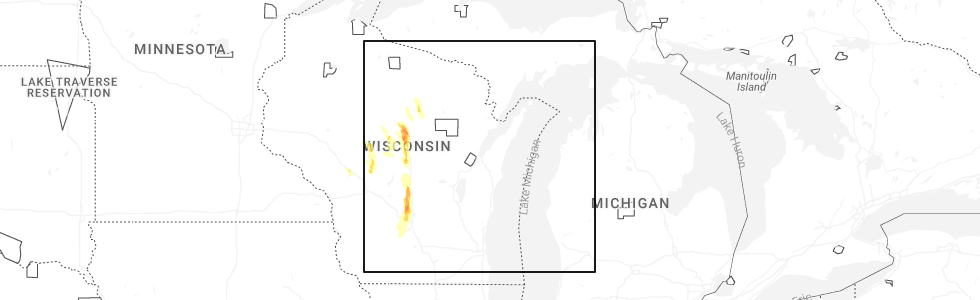
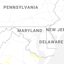
Hail Map for Wednesday, May 27, 2026
Number of Impacted Households on 5/27/2026
0
Impacted by 1" or Larger Hail
0
Impacted by 1.75" or Larger Hail
0
Impacted by 2.5" or Larger Hail
Square Miles of Populated Area Impacted on 5/27/2026
0
Impacted by 1" or Larger Hail
0
Impacted by 1.75" or Larger Hail
0
Impacted by 2.5" or Larger Hail
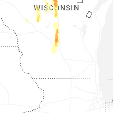
Cities Most Affected by Hail Storms of 5/27/2026
| Hail Size | Demographics of Zip Codes Affected | ||||||
|---|---|---|---|---|---|---|---|
| City | Count | Average | Largest | Pop Density | House Value | Income | Age |
| Wausau, WI | 2 | 1.88 | 2.00 | 381 | $94k | $44.1k | 39.4 |
Hail and Wind Damage Spotted on 5/27/2026
Filter by Report Type:Hail ReportsWind Reports
States Impacted
Texas, Ohio, Virginia, Indiana, West Virginia, North Carolina, Wisconsin, Oregon, Idaho, MontanaTexas
| Local Time | Report Details |
|---|---|
| 9:32 AM CDT | At 9:32 am... asos/awos site at port isabel-cameron county airport measured a wind gust of 61 mph associated with a thunderstor in cameron county TX, 20.4 miles NNE of Brownsville, TX |
| 10:06 AM CDT | Brazos santiago buo in gmz130 county TX, 23.9 miles ENE of Brownsville, TX |
| 10:15 AM CDT | At 1015 am... a spacex employee reported a 61 mph thunderstorm wind gust at starbas in cameron county TX, 20.6 miles ENE of Brownsville, TX |
Ohio
| Local Time | Report Details |
|---|---|
| 11:37 AM EDT | Trees reported down on stemen road. time estimated from rada in fairfield county OH, 19.9 miles ESE of Columbus, OH |
| 12:02 PM EDT | 5-6 inch branches down on pleasantville road. time estimated from rada in fairfield county OH, 25.8 miles ESE of Columbus, OH |
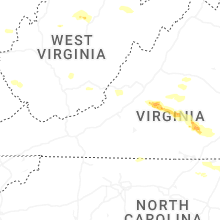
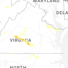
Virginia
| Local Time | Report Details |
|---|---|
| 12:30 PM EDT | There was a call for trees down near the intersection of elys frd road and yellow bottom roa in culpeper county VA, 63.7 miles N of Richmond, VA |
| 12:50 PM EDT | There was a report of tree damage near the intersection of woodlot court and millrace roa in stafford county VA, 64.8 miles N of Richmond, VA |
| 1:05 PM EDT | There was a call for trees blown down onto wires near the intersection of va-649 mill pond road and todds tavern driv in spotsylvania county VA, 50.8 miles N of Richmond, VA |
| 1:08 PM EDT | There was a call for trees blown down in the 1700 block of va-3 william stree in city of fredericks county VA, 55.6 miles N of Richmond, VA |
| 1:45 PM EDT | Tree downed onto newland roa in richmond county VA, 58.6 miles NE of Richmond, VA |
| 2:10 PM EDT | Multiple trees down along tidewater trail near occupacia road and hunters hill road. time estimated from rada in essex county VA, 51.4 miles NE of Richmond, VA |
| 2:15 PM EDT | Tree downed by thunderstorm winds near the intersection of liberty road and smith mountain road... and blocked the roadwa in pittsylvania county VA, 27.5 miles SE of Roanoke, VA |
| 2:20 PM EDT | Tree down on newland roa in richmond county VA, 56.5 miles NE of Richmond, VA |
| 2:24 PM EDT | Tree down on menokin road in richmond county. time estimated from rada in richmond county VA, 58.7 miles NE of Richmond, VA |
| 2:29 PM EDT | Tree down on kellys lane in richmond county. time estimated from rada in richmond county VA, 59.6 miles NE of Richmond, VA |
| 2:36 PM EDT | Tree down on mulberry road in richmond county. time estimated from rada in richmond county VA, 61.8 miles ENE of Richmond, VA |
| 2:36 PM EDT | Tree down on kings mill road in westmoreland county. time estimated from rada in westmoreland county VA, 64.7 miles ENE of Richmond, VA |
| 2:42 PM EDT | Multiple trees downed on ridge road at deer gap. time radar-estimate in northumberland county VA, 66.8 miles ENE of Richmond, VA |
| 2:45 PM EDT | Trees and power lines downed at dodlyt road and northumberland highway. time radar-estimate in northumberland county VA, 70.3 miles ENE of Richmond, VA |
| 2:55 PM EDT | *** 2 inj *** corrects previous tstm wnd dmg report from 1 ssw burgess. tree downed onto a vehicle with injuries reported on dupont memorial highway in heathsville. tim in northumberland county VA, 75.1 miles ENE of Richmond, VA |
| 2:55 PM EDT | *** 2 inj *** corrects previous tstm wnd dmg report from 1 ssw burgess. tree downed onto a vehicle with injuries reported on dupont memorial highway in heathsville. tim in northumberland county VA, 75.1 miles ENE of Richmond, VA |
| 2:56 PM EDT | Tree down in 1980 block of old mill roa in albemarle county VA, 61.5 miles NW of Richmond, VA |
| 3:00 PM EDT | Tree down on fontaine avenue extensio in city of charlottes county VA, 59.8 miles NW of Richmond, VA |
| 3:00 PM EDT | Large tree branches reported across the roadway in the area of a restaurant pm dupont highway. time radar-estimate in northumberland county VA, 75.8 miles WSW of Ocean City, MD |
| 3:05 PM EDT | Tree down on house off of whays creek road in northumberland count in northumberland county VA, 74.7 miles WSW of Ocean City, MD |
| 3:18 PM EDT | Tree down on hoecake road in lancaster county. time estimated from rada in lancaster county VA, 65.2 miles ENE of Richmond, VA |
| 3:31 PM EDT | 2 trees knocked down in the lake monticello area. time estimated from rada in fluvanna county VA, 47.4 miles NW of Richmond, VA |
| 3:51 PM EDT | Tree across the road on newbill school roa in halifax county VA, 67.1 miles ESE of Roanoke, VA |
| 4:26 PM EDT | Tree down on us route 58 in turbevill in halifax county VA, 61.7 miles NNW of Raleigh, NC |
| 5:30 PM EDT | A large tree was blown down by thunderstorm winds across j s holland road... blocking both lanes of the roa in henry county VA, 47.1 miles S of Roanoke, VA |
| 5:39 PM EDT | Thunderstorm winds blew down a large oak tree near the intersection of muse field road and ledbetter roa in franklin county VA, 18.9 miles SSE of Roanoke, VA |
| 6:15 PM EDT | Tree fallen across iron ridge road near rocky mount... va. time is estimated from rada in franklin county VA, 14.7 miles S of Roanoke, VA |
| 6:24 PM EDT | Tree fallen across booker t washington highway near rocky mount... va. time is estimated from rada in franklin county VA, 15.8 miles SSE of Roanoke, VA |
| 6:28 PM EDT | At least two trees were blown down along the s constitution highway by thunderstorm wind in buckingham county VA, 46.6 miles W of Richmond, VA |
| 6:30 PM EDT | Vdem called in reports of multiple trees down in botetourt county off ball park road near craig creek where front loaders were needed to remove the amount of trees that in botetourt county VA, 27.3 miles N of Roanoke, VA |
| 6:30 PM EDT | At least two large trees were blown down by thunderstorm winds in the community of eagle rock... including one tree down along craig creek roa in botetourt county VA, 26.4 miles NNE of Roanoke, VA |
| 7:00 PM EDT | A large tree was blown down by thunderstorm winds in the town of buchana in botetourt county VA, 22 miles NE of Roanoke, VA |
| 7:00 PM EDT | Multiple reports of trees down in the west end area of henrico county. time estimated from rada in henrico county VA, 10.4 miles NNE of Richmond, VA |
| 7:15 PM EDT | Tree down on crestwood dr in richmon in city of richmond county VA, 12.1 miles ENE of Richmond, VA |
| 7:39 PM EDT | Tree downed and blocking the entire road near the intersection of old wright shop road and maple driv in amherst county VA, 47.5 miles ENE of Roanoke, VA |
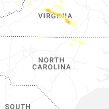
| 7:41 PM EDT | Quarter sized hail reported near Madison Heights, VA, 49.6 miles ENE of Roanoke, VA, one-inch diameter hail was observed along izaak walton road. |
| 7:45 PM EDT | A large tree was blown down onto a power line along mt. athos road... causing the power line to brea in campbell county VA, 51.2 miles ENE of Roanoke, VA |
| 7:52 PM EDT | A large tree was blown down by thunderstorm winds along stonewall roa in appomattox county VA, 54.5 miles E of Roanoke, VA |
| 7:52 PM EDT | Quarter sized hail reported near Gainesville, VA, 63.6 miles WSW of Baltimore, MD, quarter size hail reported in gainesville. |
| 7:55 PM EDT | Multiple trees down along airlie road due to thunderstorm wind in fauquier county VA, 73.3 miles WSW of Baltimore, MD |
| 8:00 PM EDT | Several reports of trees down throughout fauquier count in fauquier county VA, 73.6 miles WSW of Baltimore, MD |
| 8:00 PM EDT | Power line down near the intersection of police tower road and richmond highway near appomattox... va. time is estimated from rada in appomattox county VA, 59.3 miles E of Roanoke, VA |
| 8:00 PM EDT | Tree down on toddsbury road in lynchburg... va... blocking all lanes of traffic. time is estimated from rada in campbell county VA, 41.1 miles E of Roanoke, VA |
| 8:01 PM EDT | A large tree was blown down by thunderstorm winds along walton driv in appomattox county VA, 60.3 miles E of Roanoke, VA |
| 8:08 PM EDT | A large tree was blown down by thunderstorm winds near the intersection of morning star road and s fork roa in appomattox county VA, 62.7 miles W of Richmond, VA |
| 8:56 PM EDT | Quarter sized hail reported near Green Bay, VA, 44.1 miles SW of Richmond, VA, quarter sized hail reported at the intersection of us 360 and cheatham rd in prince edward county. |
| 8:58 PM EDT | Tree down on us 360 near virso rd in prince edward county. time estimated from rada in prince edward county VA, 50.1 miles SW of Richmond, VA |
| 9:00 PM EDT | Wire down on us 360 just south of burkeville. time estimated from rada in prince edward county VA, 39.4 miles SW of Richmond, VA |
| 9:09 PM EDT | Large tree fallen across the roadway near the intersection of harrison street and lynn street near brookneal... va. time is estimated by rada in campbell county VA, 57.3 miles ESE of Roanoke, VA |
Indiana
| Local Time | Report Details |
|---|---|
| 12:56 PM EDT | 700 e south of us 52 flooded and an 8-inch diameter limb down in the same area with 2.2 inches of rain. time very roughly estimated from rada in rush county IN, 47.7 miles ESE of Indianapolis, IN |
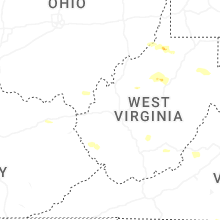
West Virginia
| Local Time | Report Details |
|---|---|
| 3:04 PM EDT | Tree down on middle horse creek rd in julian. time estimated by rada in boone county WV, 18.7 miles SW of Charleston, WV |
| 3:12 PM EDT | Tree down in the 4300 block of ashford-nellis rd near ashford... wv. time estimated via rada in boone county WV, 11.9 miles S of Charleston, WV |
| 3:18 PM EDT | Tree down on lines near richwood run rd. timing based on rada in wetzel county WV, 59.7 miles NW of Elkins, WV |
| 3:27 PM EDT | Tree blocking mannington roa in wetzel county WV, 55.3 miles NW of Elkins, WV |
| 3:27 PM EDT | Power line down on shortline hw in wetzel county WV, 58.1 miles NW of Elkins, WV |
| 3:29 PM EDT | Tree down near bates run rd... blocking both lanes of traffic... very hard to see due to weather conditions... there are busses being blocked by the tree as well (lat:3 in wetzel county WV, 59.4 miles NW of Elkins, WV |
| 3:36 PM EDT | Tree down blocking sycamore fork rd near the doddridge county line. time estimated by rada in harrison county WV, 49.8 miles NW of Elkins, WV |
| 3:46 PM EDT | Power lines and tree down in the 2900 block of gregorys run rd outside of clarksburg. no power in the area. time estimated via rada in harrison county WV, 40.9 miles NW of Elkins, WV |
| 3:47 PM EDT | Tree down at the 600 blk of trouser leg rd near benedum hollow rd. time estimated via rada in harrison county WV, 47.4 miles NW of Elkins, WV |
| 4:24 PM EDT | Pictures on social media of a tree down blocking part of bear wallow rd near thomas ridge rd. time estimated by rada in mason county WV, 36.8 miles NNW of Charleston, WV |
| 4:27 PM EDT | Pictures on social media of a large tree down blocking the entire road in the 3800 block of ten mile creek r in mason county WV, 35.9 miles NNW of Charleston, WV |
| 4:32 PM EDT | Received pictures via social media of various large hardwood trees down along left freemans creek road... churchville road... and freemans creek road. time estimated vi in lewis county WV, 41 miles WNW of Elkins, WV |
| 4:35 PM EDT | Several trees down along valley chapel road reported through social media. time estimated by rada in lewis county WV, 37.8 miles WNW of Elkins, WV |
| 4:37 PM EDT | Tree down in the 2300 block of baier ridge road near bar ridge road time estimated via rada in jackson county WV, 35.8 miles NNW of Charleston, WV |
| 4:55 PM EDT | Tree in roadway on cr-40/4 (bens run rd). coincident with a power outage affecting 35 customers due to inclement weathe in lewis county WV, 40.7 miles W of Elkins, WV |
| 5:06 PM EDT | Tree down on powerlines along haw run rd at alpin ridge rd. time estimated by rada in jackson county WV, 27.7 miles N of Charleston, WV |
| 5:11 PM EDT | Tree damage resulting in approximately 100 customers without power. time is estimated by rada in roane county WV, 24.3 miles NNE of Charleston, WV |
| 5:15 PM EDT | Trees down along route 21 in tucker county WV, 24.2 miles NE of Elkins, WV |
| 5:30 PM EDT | Tree is down on highland trail near alderson... wv... blocking one lane. time is estimated from rada in greenbrier county WV, 47.7 miles NW of Roanoke, VA |
| 5:35 PM EDT | A large tree was blown down by thunderstorm winds onto an unoccupied vehicle along mike stuart roa in greenbrier county WV, 43.6 miles NW of Roanoke, VA |
| 5:35 PM EDT | Tree down partially blocking tallmansville rd in the vicinity of tallmansville baptist church near goodwin rd and preacher tenney rd. time estimated by rada in upshur county WV, 17.1 miles W of Elkins, WV |
North Carolina
| Local Time | Report Details |
|---|---|
| 3:30 PM EDT | Wind gusts moved patio furniture from household out into the yard and snapped several branches around the area as thunderstorms moved through. report received via socia in onslow county NC, 58.1 miles NE of Wilmington, NC |
| 3:44 PM EDT | Tree down near the intersection of park road and tolbert stree in rockingham county NC, 53.5 miles S of Roanoke, VA |
| 3:56 PM EDT | Tree down on perkinson road near the nc/va state lin in rockingham county NC, 54.5 miles SSE of Roanoke, VA |
| 4:10 PM EDT | Trees down at eupeptic springs rd and jennings r in iredell county NC, 53.7 miles N of Charlotte, NC |
| 4:10 PM EDT | Corrects previous tstm wnd dmg report from 2 sse union grove. trees down on pioneer roa in iredell county NC, 53.6 miles N of Charlotte, NC |
| 4:10 PM EDT | Trees down on west memorial highway and myers mill roa in iredell county NC, 55.8 miles N of Charlotte, NC |
| 4:20 PM EDT | Trees down on pioneer roa in iredell county NC, 53.6 miles N of Charlotte, NC |
| 4:25 PM EDT | Trees down on campground rd at mocksville hw in iredell county NC, 45.2 miles N of Charlotte, NC |
| 6:24 PM EDT | Report of power outage caused by fallen trees or limbs damaging equipment from duke energ in halifax county NC, 58.4 miles NE of Raleigh, NC |
| 6:28 PM EDT | Halifax county em reported numerous trees down in western and central halifax count in halifax county NC, 61.2 miles NE of Raleigh, NC |
| 6:30 PM EDT | Several trees down... power lines down and damage to nearby farm between the inex and 3200 block of nc-5 in warren county NC, 44.2 miles NE of Raleigh, NC |
| 6:38 PM EDT | Tree down on a powerline near the hollister area co-located with nearly 400 power outage in halifax county NC, 51.2 miles NE of Raleigh, NC |
| 7:03 PM EDT | Several trees and power lines down across the city of gastoni in gaston county NC, 19.6 miles W of Charlotte, NC |
| 7:21 PM EDT | Numerous reports of trees down from littleton... halifax and into the scotland neck are in halifax county NC, 75.6 miles ENE of Raleigh, NC |
| 8:33 PM EDT | Tree down blocking the road near the intersection of siler city glendon rd and nc 90 in chatham county NC, 48.3 miles WSW of Raleigh, NC |
| 8:35 PM EDT | Tree down on powerlines on the 200 block of everette dowdy r in chatham county NC, 34.6 miles WSW of Raleigh, NC |
| 8:36 PM EDT | Tree down on 100 block of jesse phillips rd blocking both lanes of trave in moore county NC, 49.5 miles WSW of Raleigh, NC |
| 8:40 PM EDT | Tree down on bonlee carbonton rd and lucian hilliard r in chatham county NC, 44.6 miles WSW of Raleigh, NC |
| 8:50 PM EDT | Tree down blocking one lane of the 800 block of putnam glendon r in moore county NC, 48.6 miles WSW of Raleigh, NC |
| 9:05 PM EDT | Couple trees down in the area around the intersection between dycus road and camelot lan in lee county NC, 42.6 miles SW of Raleigh, NC |
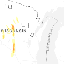
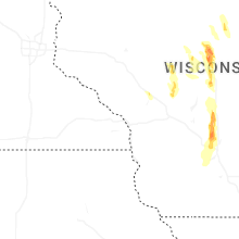
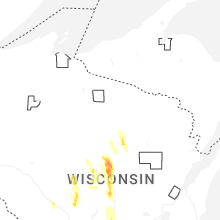
Wisconsin
| Local Time | Report Details |
|---|---|
| 4:12 PM CDT | Quarter sized hail reported near Wausau, WI, 48.2 miles SSW of Rhinelander, WI |
| 4:13 PM CDT | Quarter sized hail reported near Wausau, WI, 47.4 miles SSW of Rhinelander, WI |
| 4:15 PM CDT | Quarter sized hail reported near Wausau, WI, 49.9 miles SSW of Rhinelander, WI |
| 4:16 PM CDT | Several trees down in the city of wausau. vehicle windows were smashed by large hai in marathon county WI, 50.1 miles SSW of Rhinelander, WI |
| 4:16 PM CDT | Quarter sized hail reported near Wausau, WI, 46 miles SSW of Rhinelander, WI |
| 4:16 PM CDT | Ping Pong Ball sized hail reported near Wausau, WI, 48.6 miles SSW of Rhinelander, WI, reported at wsaw-tv. |
| 4:17 PM CDT | Half Dollar sized hail reported near Wausau, WI, 50.6 miles SSW of Rhinelander, WI, report from mping: half dollar (1.25 in.). |
| 4:18 PM CDT | Golf Ball sized hail reported near Wausau, WI, 51.6 miles SSW of Rhinelander, WI |
| 4:19 PM CDT | Quarter sized hail reported near Wausau, WI, 48.6 miles SSW of Rhinelander, WI, quarter size hail at the wausau downtown airport. |
| 4:19 PM CDT | Quarter sized hail reported near Wausau, WI, 48.8 miles SSW of Rhinelander, WI |
| 4:20 PM CDT | Ping Pong Ball sized hail reported near Wausau, WI, 47.8 miles SSW of Rhinelander, WI |
| 4:25 PM CDT | Quarter sized hail reported near Schofield, WI, 52.5 miles S of Rhinelander, WI |
| 4:34 PM CDT | Ping Pong Ball sized hail reported near Mosinee, WI, 55.4 miles S of Rhinelander, WI, report from mping: ping pong ball (1.50 in.). |
| 4:37 PM CDT | Hen Egg sized hail reported near Wausau, WI, 51.1 miles SSW of Rhinelander, WI, report from mping: hen egg (2.00 in.). |
| 4:46 PM CDT | Half Dollar sized hail reported near Mosinee, WI, 56 miles S of Rhinelander, WI, report from mping: half dollar (1.25 in.). |
| 4:48 PM CDT | Half Dollar sized hail reported near Mosinee, WI, 55.3 miles S of Rhinelander, WI, report from mping: half dollar (1.25 in.). |
| 4:49 PM CDT | Half Dollar sized hail reported near Mosinee, WI, 55.2 miles S of Rhinelander, WI, report from mping: half dollar (1.25 in.). |
| 4:50 PM CDT | Half Dollar sized hail reported near Mosinee, WI, 55.9 miles S of Rhinelander, WI, report from mping: half dollar (1.25 in.). |
| 4:50 PM CDT | Several trees down at river park in mosinee. time estimated by radar. report from wsaw-t in marathon county WI, 59.7 miles SSW of Rhinelander, WI |
| 4:51 PM CDT | Half Dollar sized hail reported near Mosinee, WI, 55.2 miles S of Rhinelander, WI, report from mping: half dollar (1.25 in.). |
| 5:38 PM CDT | Quarter sized hail reported near Plover, WI, 78.7 miles W of Green Bay, WI |
| 5:53 PM CDT | Quarter sized hail reported near Loyal, WI, 73.3 miles NNE of La Crosse, WI |
| 6:46 PM CDT | 1 tree blown dow in adams county WI, 72.5 miles N of Madison, WI |
| 6:51 PM CDT | 1 tree blown dow in adams county WI, 61.8 miles NNW of Madison, WI |
| 6:56 PM CDT | 1 tree blown dow in adams county WI, 64.2 miles NNW of Madison, WI |
| 6:58 PM CDT | Quarter sized hail reported near Black River Falls, WI, 39.9 miles NNE of La Crosse, WI, photo confirmed. |
| 7:15 PM CDT | Storm damage reported in marquette county WI, 49.7 miles N of Madison, WI |
| 7:15 PM CDT | Storm damage reported in marquette county WI, 49.7 miles N of Madison, WI |
| 7:16 PM CDT | Quarter sized hail reported near Oxford, WI, 49.7 miles N of Madison, WI |
| 7:40 PM CDT | Reports of a few trees down in northwestern columbia county. time estimated from rada in columbia county WI, 38.5 miles NNW of Madison, WI |
| 8:00 PM CDT | Reports of trees and powerlines down. time estimated from rada in sauk county WI, 23.9 miles NNW of Madison, WI |
| 8:02 PM CDT | Quarter sized hail reported near Black River Falls, WI, 38.6 miles NNE of La Crosse, WI |
| 8:27 PM CDT | Reports of a few trees and powerlines down near sauk city. time estimated from rada in sauk county WI, 22 miles NW of Madison, WI |
| 8:41 PM CDT | Report of a tree down across county highway y north of mazomanie. time estimated from rada in dane county WI, 22.2 miles WNW of Madison, WI |
Oregon
| Local Time | Report Details |
|---|---|
| 3:30 PM MDT | Asos station kreo rom in malheur county OR, 91.7 miles SE of Burns, OR |
| 2:43 PM PDT | Mesonet station rlfo3 riddle mountai in harney county OR, 43.7 miles SE of Burns, OR |
| 3:45 PM PDT | Quarter sized hail reported near Lakeview, OR, 25 miles WNW of Lakeview, OR, odot webcams show hail covering highway 140 estimated approx 1 inch deep. |
| 4:14 PM PDT | Gust reported by odot weather statio in klamath county OR, 38.7 miles WNW of Lakeview, OR |
| 4:22 PM PDT | Quarter sized hail reported near Bly, OR, 38.4 miles WNW of Lakeview, OR, odot cams show hail covering highway 140 at bly... or... estimated depth of >1 inch. |
| 4:45 PM PDT | Quarter sized hail reported near Bonanza, OR, 55 miles WNW of Lakeview, OR, odot road camera shows hail covering highway 140 at bly mountain at a depth estimated as >1 inch. |
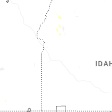
Idaho
| Local Time | Report Details |
|---|---|
| 4:15 PM MDT | Inl sand dune in butte county ID, 45.6 miles WNW of Idaho Falls, ID |
| 4:20 PM MDT | Quarter sized hail reported near Indian Valley, ID, 66.8 miles N of Boise, ID, social media post showing 1" hail. |
Montana
| Local Time | Report Details |
|---|---|
| 1:20 AM MDT | Augusta n montana mesonet reported a 60 mph wind gus in teton county MT, 49.6 miles W of Great Falls, MT |
| 1:50 AM MDT | Mesonet station gw6973 chotea in teton county MT, 42.8 miles WNW of Great Falls, MT |
| 1:55 AM MDT | Mesonet station gw6973 chotea in teton county MT, 42.8 miles WNW of Great Falls, MT |
| 2:00 AM MDT | Mesonet station gw6973 chotea in teton county MT, 42.8 miles WNW of Great Falls, MT |
Connect with Interactive Hail Maps