

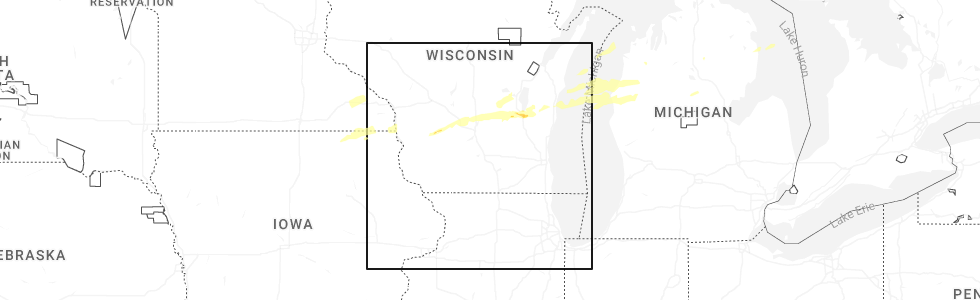
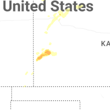
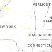
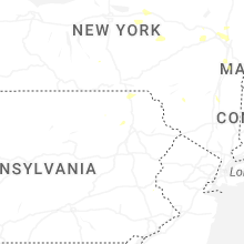
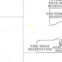
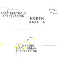
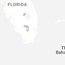
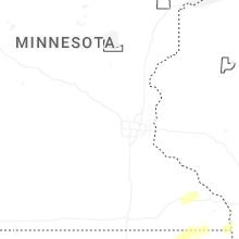
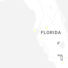
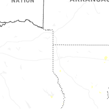
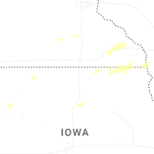
Hail Map for Wednesday, July 1, 2026
Number of Impacted Households on 7/1/2026
0
Impacted by 1" or Larger Hail
0
Impacted by 1.75" or Larger Hail
0
Impacted by 2.5" or Larger Hail
Square Miles of Populated Area Impacted on 7/1/2026
0
Impacted by 1" or Larger Hail
0
Impacted by 1.75" or Larger Hail
0
Impacted by 2.5" or Larger Hail
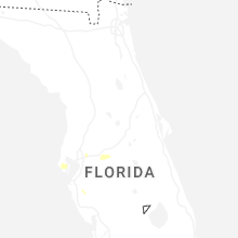
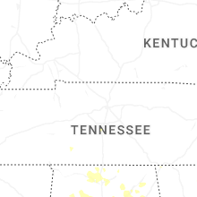
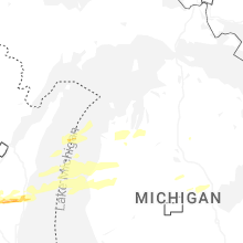
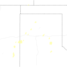
Cities Most Affected by Hail Storms of 7/1/2026
| Hail Size | Demographics of Zip Codes Affected | ||||||
|---|---|---|---|---|---|---|---|
| City | Count | Average | Largest | Pop Density | House Value | Income | Age |
| Fond Du Lac, WI | 8 | 2.28 | 3.25 | 466 | $97k | $44.4k | 40.1 |
| Plymouth, WI | 3 | 2.08 | 2.25 | 177 | $124k | $48.7k | 40.9 |
| Sheboygan, WI | 2 | 2.13 | 2.25 | 665 | $113k | $50.6k | 41.0 |
| Rosendale, WI | 1 | 2.50 | 2.50 | 49 | $112k | $51.9k | 39.7 |
| Glenbeulah, WI | 1 | 2.00 | 2.00 | 27 | $98k | $47.6k | 42.6 |
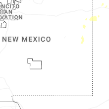
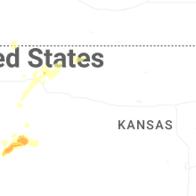
| Gem, KS | 1 | 2.00 | 2.00 | 2 | $29k | $41.7k | 40.7 |
| Syracuse, KS | 1 | 1.75 | 1.75 | 0 | $62k | $31.6k | 32.3 |
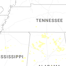
| Gadsden, AL | 1 | 1.75 | 1.75 | 280 | $60k | $27.6k | 39.3 |
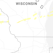
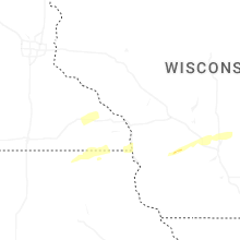
Hail and Wind Damage Spotted on 7/1/2026
Filter by Report Type:Hail ReportsWind Reports
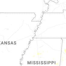
States Impacted
Wisconsin, Iowa, Michigan, Alabama, Pennsylvania, Louisiana, Georgia, New York, North Carolina, Mississippi, Texas, Tennessee, Vermont, Montana, South Dakota, Colorado, Arkansas, New Hampshire, Idaho, Kansas, Massachusetts, NebraskaWisconsin
| Local Time | Report Details |
|---|---|
| 7:11 AM CDT | One tree down on galilee roa in waupaca county WI, 50.5 miles WSW of Green Bay, WI |
| 7:39 AM CDT | Trees and powerlines down in the city of appleto in outagamie county WI, 25.9 miles SW of Green Bay, WI |
| 7:44 AM CDT | Storm damage reported in winnebago county WI, 45.8 miles SW of Green Bay, WI |
| 7:45 AM CDT | Trees and powerlines dow in winnebago county WI, 43.8 miles SW of Green Bay, WI |
| 7:53 AM CDT | Trees and power lines dow in calumet county WI, 26.6 miles SSW of Green Bay, WI |
| 8:12 AM CDT | Trees and powerlines dow in brown county WI, 4.5 miles WSW of Green Bay, WI |
| 8:12 AM CDT | Western portion of village of howard. many large trees uprooted. willow tree collapsed. time estimated from rada in brown county WI, 8.8 miles NW of Green Bay, WI |
| 8:13 AM CDT | Trees and powerlines dow in brown county WI, 1 miles W of Green Bay, WI |
| 8:14 AM CDT | Trees and powerlines dow in brown county WI, 6.4 miles S of Green Bay, WI |
| 8:19 AM CDT | Wire down 1806 oak leaf d in brown county WI, 0.5 miles ESE of Green Bay, WI |
| 8:30 AM CDT | Wires down on main and klondik in brown county WI, 0.5 miles ESE of Green Bay, WI |
| 8:34 AM CDT | Trees and power lines dow in kewaunee county WI, 15.4 miles E of Green Bay, WI |
| 8:40 AM CDT | Trees and powerlines dow in kewaunee county WI, 19.5 miles E of Green Bay, WI |
| 8:51 AM CDT | Trees and power lines down in the city... including at peterson par in kewaunee county WI, 29.1 miles ENE of Green Bay, WI |
| 8:51 AM CDT | Trees and power lines dow in door county WI, 28.9 miles ENE of Green Bay, WI |
| 9:04 AM CDT | Trees dow in door county WI, 38.8 miles NE of Green Bay, WI |
| 9:26 AM CDT | Trees and powerlines dow in door county WI, 57.2 miles NE of Green Bay, WI |
| 10:17 AM CDT | Quarter sized hail reported near La Valle, WI, 51.3 miles NW of Madison, WI, time est from radar. |
| 10:43 AM CDT | Quarter sized hail reported near Wisconsin Dells, WI, 42.8 miles NNW of Madison, WI, from social media. time est from radar. |
| 10:45 AM CDT | Tree downe in adams county WI, 44.5 miles NNW of Madison, WI |
| 11:37 AM CDT | Quarter sized hail reported near Markesan, WI, 47.7 miles NNE of Madison, WI, from social media. time est from radar. |
| 11:50 AM CDT | Ping Pong Ball sized hail reported near Brandon, WI, 54.7 miles NNE of Madison, WI, size est from social media pics sent to local media shared by county em. time est from radar. |
| 12:00 PM CDT | Tennis Ball sized hail reported near Rosendale, WI, 59 miles NE of Madison, WI, size est from social media pics sent to local media shared by county em. time est from radar. |
| 12:00 PM CDT | Quarter sized hail reported near Brandon, WI, 58.7 miles NE of Madison, WI, report from mping: quarter (1.00 in.). |
| 12:10 PM CDT | Half Dollar sized hail reported near Brandon, WI, 58.7 miles NE of Madison, WI, report from mping: half dollar (1.25 in.). |
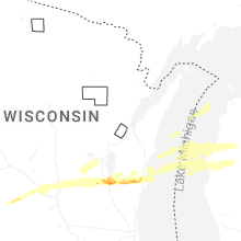
| 12:15 PM CDT | Hen Egg sized hail reported near Fond Du Lac, WI, 58.7 miles SSW of Green Bay, WI, from social media picture. time est from radar. |
| 12:20 PM CDT | Hen Egg sized hail reported near Fond Du Lac, WI, 56.8 miles SSW of Green Bay, WI, picture shared by local media. time est from radar. |
| 12:23 PM CDT | Quarter sized hail reported near Fond Du Lac, WI, 58.2 miles SSW of Green Bay, WI, report from mping: quarter (1.00 in.). |
| 12:23 PM CDT | Quarter sized hail reported near Fond Du Lac, WI, 59.4 miles SSW of Green Bay, WI, report from mping: quarter (1.00 in.). |
| 12:24 PM CDT | Golf Ball sized hail reported near Fond Du Lac, WI, 57.2 miles SSW of Green Bay, WI, corner of rolling meadows and hickory. |
| 12:25 PM CDT | Golf Ball sized hail reported near Fond Du Lac, WI, 56.3 miles SSW of Green Bay, WI, size est from social media pics sent to local media shared by county em. time est from radar. |
| 12:25 PM CDT | Tennis Ball sized hail reported near Fond Du Lac, WI, 56.8 miles SSW of Green Bay, WI, size est from social media pics sent to local media shared by county em. time est from radar. |
| 12:25 PM CDT | Hen Egg sized hail reported near Fond Du Lac, WI, 58.1 miles SSW of Green Bay, WI, size est from social media pics sent to local media shared by county em. time est from radar. |
| 12:25 PM CDT | Tea Cup sized hail reported near Fond Du Lac, WI, 56.3 miles SSW of Green Bay, WI, picture from social media that included a ruler. time est from radar. |
| 12:26 PM CDT | Quarter sized hail reported near Fond Du Lac, WI, 56.4 miles SSW of Green Bay, WI, report from mping: quarter (1.00 in.). |
| 12:28 PM CDT | Tea Cup sized hail reported near Fond Du Lac, WI, 58.9 miles SSW of Green Bay, WI, approx 1 mile ssw of the intersection of i-41 and us hwy 151. |
| 12:30 PM CDT | Ping Pong Ball sized hail reported near Fond Du Lac, WI, 56.4 miles SSW of Green Bay, WI, 4 miles ese of fond du lac. time est from radar. |
| 12:30 PM CDT | Ping Pong Ball sized hail reported near Fond Du Lac, WI, 56.7 miles SSW of Green Bay, WI |
| 12:30 PM CDT | Half Dollar sized hail reported near Fond Du Lac, WI, 59.4 miles SSW of Green Bay, WI, report from mping: half dollar (1.25 in.). |
| 12:38 PM CDT | Ping Pong Ball sized hail reported near Fond Du Lac, WI, 55.5 miles SSW of Green Bay, WI, report from mping: ping pong ball (1.50 in.). |
| 12:55 PM CDT | Hen Egg sized hail reported near Glenbeulah, WI, 49.9 miles S of Green Bay, WI, picture from social media. time est from radar. |
| 12:58 PM CDT | Hen Egg sized hail reported near Plymouth, WI, 48.5 miles S of Green Bay, WI, from social media picture. time est from radar. |
| 1:00 PM CDT | Hen Egg sized hail reported near Plymouth, WI, 52.7 miles S of Green Bay, WI, time est from radar. |
| 1:00 PM CDT | Half Dollar sized hail reported near Plymouth, WI, 52.8 miles S of Green Bay, WI, mping. time est from radar. |
| 1:05 PM CDT | Golf Ball sized hail reported near Plymouth, WI, 53 miles S of Green Bay, WI, time est from radar. |
| 1:05 PM CDT | Quarter sized hail reported near Plymouth, WI, 53 miles S of Green Bay, WI, mping. time est from radar. |
| 1:15 PM CDT | Quarter sized hail reported near Sheboygan, WI, 48.8 miles S of Green Bay, WI, from social media. time est from radar. |
| 1:20 PM CDT | Hen Egg sized hail reported near Sheboygan, WI, 53.1 miles SSE of Green Bay, WI, from social media picture. time est from radar. |
| 1:20 PM CDT | Half Dollar sized hail reported near Sheboygan, WI, 52.9 miles SSE of Green Bay, WI, mping. time est from radar. |
| 1:20 PM CDT | Quarter sized hail reported near Sheboygan, WI, 53.7 miles SSE of Green Bay, WI, time est from radar. |
| 1:20 PM CDT | Hen Egg sized hail reported near Sheboygan, WI, 52.8 miles SSE of Green Bay, WI, time est from radar. |
| 10:28 PM CDT | Power line down in ontario. time estimated from rada in vernon county WI, 33.6 miles E of La Crosse, WI |
| 11:11 PM CDT | Corrects previous tstm wnd dmg report from 1 s plainfield. few trees dow in waushara county WI, 76.2 miles WSW of Green Bay, WI |
| 11:33 PM CDT | Corrects previous tstm wnd dmg report from 1 n wild rose. few trees down. time estimated by rada in waushara county WI, 65.3 miles WSW of Green Bay, WI |
| 11:44 PM CDT | Corrects previous tstm wnd dmg report from redgranite. trees and powerlines dow in waushara county WI, 63.2 miles WSW of Green Bay, WI |
| 11:45 PM CDT | Tree fell on a hous in waushara county WI, 63.5 miles WSW of Green Bay, WI |
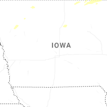
Iowa
| Local Time | Report Details |
|---|---|
| 7:27 AM CDT | Multiple 8 to 10 inch diameter branches down around town. time estimated via rada in sioux county IA, 39.7 miles SSE of Sioux Falls, SD |
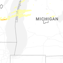
Michigan
| Local Time | Report Details |
|---|---|
| 11:22 AM EDT | Power lines down northwest of honor. time estimated via rada in benzie county MI, 22.9 miles WSW of Traverse City, MI |
| 11:24 AM EDT | Lots of small branches down... bbq blown off deck. estimated 50 mph peak gus in leelanau county MI, 13.8 miles WNW of Traverse City, MI |
| 11:24 AM EDT | Tree snapped and fell onto a car parked on the street. time estimated by rada in leelanau county MI, 10.6 miles NW of Traverse City, MI |
| 11:28 AM EDT | Trees down at m-22 and putnam rd. time estimated via rada in leelanau county MI, 18.7 miles N of Traverse City, MI |
| 11:34 AM EDT | Trees dow in leelanau county MI, 8.7 miles W of Traverse City, MI |
| 11:36 AM EDT | Report of a willow tree snapped. time estimated by rada in grand traverse county MI, 7.7 miles S of Traverse City, MI |
| 11:38 AM EDT | Report via social media of damage between northport and omena. numerous cherry trees felled or leaning... along with a 16 x 16 garage door blown into the structure and in leelanau county MI, 22.8 miles N of Traverse City, MI |
| 11:47 AM EDT | Trees down. time estimate in antrim county MI, 13.6 miles NE of Traverse City, MI |
| 11:54 AM EDT | Report of a 12 inch diameter tree limb downed near alden. time estimated by rada in antrim county MI, 18.9 miles ENE of Traverse City, MI |
| 11:59 AM EDT | Picture on social media of tree limbs downed on sixmile lake. time estimated by rada in charlevoix county MI, 32.7 miles NE of Traverse City, MI |
| 12:00 PM EDT | Lots of downed trees and power outages across antrim county. initial reports suggest worst damage between torch lake and mancelona. time estimate in antrim county MI, 28.5 miles ENE of Traverse City, MI |
| 12:01 PM EDT | Delayed report. image shared via social media. two trees downed on a property east of the mallard golf course near east jordan. one tree was downed on the house... the in charlevoix county MI, 34.5 miles NE of Traverse City, MI |
| 12:03 PM EDT | Report of a barn door blown off the structure north of kalkaska. time estimated by rada in kalkaska county MI, 22.4 miles E of Traverse City, MI |
| 12:05 PM EDT | Tree took down power line at a residence in excelsior township. time estimated by rada in kalkaska county MI, 28.5 miles E of Traverse City, MI |
| 12:07 PM EDT | Reports of several trees and tree limbs downed in the manistee lake (kalkaska county) area. power outages reported. time estimated by rada in kalkaska county MI, 29.9 miles E of Traverse City, MI |
| 12:09 PM EDT | Trees down in mancelon in antrim county MI, 29 miles ENE of Traverse City, MI |
| 12:18 PM EDT | Power lines down. time estimate in charlevoix county MI, 41.7 miles NE of Traverse City, MI |
| 12:19 PM EDT | Trees down in and around boyne cit in charlevoix county MI, 43 miles NE of Traverse City, MI |
| 12:22 PM EDT | Picture on social media. thunderstorm winds toppled the fireworks tent outside the gaylord menards. time estimated by rada in otsego county MI, 47.8 miles ENE of Traverse City, MI |
| 12:23 PM EDT | Estimated gust of 60-70 mp in otsego county MI, 48.7 miles ENE of Traverse City, MI |
| 12:23 PM EDT | Report of tree damage in the gaylord west subdivision. time estimated by rada in otsego county MI, 48.2 miles ENE of Traverse City, MI |
| 12:24 PM EDT | Asos station kglr gaylord - otsego county airpor in otsego county MI, 49.3 miles ENE of Traverse City, MI |
| 12:27 PM EDT | Picture on social media of trees downed at heather lane and north down river road. time estimated by rada in crawford county MI, 45.5 miles E of Traverse City, MI |
| 12:30 PM EDT | Trees down at sparr rd. and marquardt r in otsego county MI, 54.4 miles ENE of Traverse City, MI |
| 12:58 PM EDT | Picture of a large tree limb downed on social media. time estimated by rada in montmorency county MI, 34.3 miles W of Alpena, MI |
| 1:01 PM EDT | Picture of a tree snapped halfway up from the base at clear lake state park. time estimated by rada in montmorency county MI, 36.2 miles W of Alpena, MI |
| 1:07 PM EDT | Trees and power lines dow in alcona county MI, 19.4 miles SSW of Alpena, MI |
| 1:08 PM EDT | Power lines down. time estimate in alcona county MI, 41.1 miles SSW of Alpena, MI |
| 1:15 PM EDT | Power lines dow in iosco county MI, 44.8 miles SSW of Alpena, MI |
| 1:19 PM EDT | Image shared via social media of tree down on vehicl in alpena county MI, 14 miles W of Alpena, MI |
| 1:23 PM EDT | Corrects previous tstm wnd dmg report from 2 w west branch. lines down/power outages reported around west branch. time estimate in ogemaw county MI, 67.6 miles SW of Alpena, MI |
| 1:23 PM EDT | Corrects previous tstm wnd dmg report from 2 w west branch. lines down/power outages reported around west branch. time estimate in ogemaw county MI, 67.6 miles SW of Alpena, MI |
| 1:29 PM EDT | Image of tree down shared via social media. time estimate in alpena county MI, 7.5 miles NNW of Alpena, MI |
| 1:30 PM EDT | Delayed report. multiple trees downed in greenbush. time estimate in alcona county MI, 33.1 miles S of Alpena, MI |
| 1:53 PM EDT | Mesonet station xtaw tawas poin in iosco county MI, 56 miles S of Alpena, MI |
| 9:55 PM EDT | Multiple tree limbs downed onto the street in the michawaye subdivisio in otsego county MI, 49 miles ENE of Traverse City, MI |
| 2:40 AM EDT | Tree damage reported-- 50 foot tall birch tre in kalkaska county MI, 36.3 miles E of Traverse City, MI |
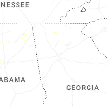
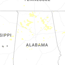
Alabama
| Local Time | Report Details |
|---|---|
| 12:26 PM CDT | Tree down blocking roadwa in jefferson county AL, 10.9 miles W of Birmingham, AL |
| 12:59 PM CDT | Quarter sized hail reported near Joppa, AL, 55.5 miles NNE of Birmingham, AL, hail up to quarter sized near hulaco reported. |
| 1:00 PM CDT | Trees downed on birmingport r in jefferson county AL, 14.3 miles W of Birmingham, AL |
| 1:20 PM CDT | Quarter sized hail reported near Fyffe, AL, 48.8 miles SW of Chattanooga, TN, quarter sized hail reported at neacc. |
| 1:51 PM CDT | Tree down on line in walker county AL, 27.4 miles NW of Birmingham, AL |
| 1:51 PM CDT | Tree dow in walker county AL, 28.2 miles NW of Birmingham, AL |
| 1:57 PM CDT | Trees down blocking one lan in walker county AL, 29.5 miles WNW of Birmingham, AL |
| 1:59 PM CDT | Quarter sized hail reported near Rainsville, AL, 48.2 miles SW of Chattanooga, TN, a tree was knocked down onto a power line. power was out at this location at 217 reel road. |
| 1:59 PM CDT | Corrects previous hail report from 1 e powell. a tree was knocked down onto a power line. power was out at this location at 217 reel roa in dekalb county AL, 48.2 miles SW of Chattanooga, TN |
| 2:09 PM CDT | Tree uprooted and on line in walker county AL, 34 miles NW of Birmingham, AL |
| 2:11 PM CDT | Tree dow in walker county AL, 34.9 miles NW of Birmingham, AL |
| 2:40 PM CDT | Tree dow in walker county AL, 43.2 miles NW of Birmingham, AL |
| 2:46 PM CDT | Trees dow in walker county AL, 52.8 miles NW of Birmingham, AL |
| 2:47 PM CDT | Photo and report from social media of a tree down on a house near county road 110 and 460. time estimated from rada in lawrence county AL, 27.7 miles SE of Florence, AL |
| 3:06 PM CDT | Quarter sized hail reported near Haleyville, AL, 36 miles S of Florence, AL, quarter-size hail reported around 3 miles north of haleyville. |
| 3:09 PM CDT | Trees and power lines were downed around the marion county side of haleyvill in marion county AL, 39.4 miles S of Florence, AL |
| 3:11 PM CDT | Photo from social media of a tree split and downed onto power lines. time estimated from rada in lawrence county AL, 22.4 miles SE of Florence, AL |
| 3:17 PM CDT | Trees and power lines were downed around bear cree in marion county AL, 36.6 miles S of Florence, AL |
| 3:18 PM CDT | Tree down near whipporwill ln and cr 211. time estimate in shelby county AL, 27.1 miles S of Birmingham, AL |
| 3:27 PM CDT | Trees and power lines were downed around hacklebur in marion county AL, 36.9 miles SSW of Florence, AL |
| 3:30 PM CDT | Tree down on county road 57. time estimated from rada in franklin county AL, 33.3 miles SSW of Florence, AL |
| 3:35 PM CDT | Trees and power lines were downed around hamilto in marion county AL, 48.9 miles SSW of Florence, AL |
| 3:41 PM CDT | Tree down near county road 21. time estimated from rada in franklin county AL, 26.9 miles SW of Florence, AL |
| 3:41 PM CDT | Tree down and power lines down near potts street. time estimated from rada in franklin county AL, 19.5 miles S of Florence, AL |
| 3:41 PM CDT | Tree down on tuscaloosa street. time estimated from rada in franklin county AL, 20.9 miles S of Florence, AL |
| 3:41 PM CDT | Tree down near clay avenue. time estimated from rada in franklin county AL, 19.7 miles S of Florence, AL |
| 3:41 PM CDT | Tree down on underwood road. time estimated from rada in franklin county AL, 19.4 miles S of Florence, AL |
| 3:41 PM CDT | Tree down on summit street. time estimated from rada in franklin county AL, 19 miles S of Florence, AL |
| 3:41 PM CDT | Tree down near duncan creek road. time estimated from rada in franklin county AL, 20.1 miles SSW of Florence, AL |
| 3:44 PM CDT | Tree down near county road 23 and cedar street. time estimated from rada in franklin county AL, 36.3 miles SW of Florence, AL |
| 3:44 PM CDT | Tree down on county road 58 near the frankfort community. time estimated from rada in franklin county AL, 19.3 miles SSW of Florence, AL |
| 3:44 PM CDT | Tree down near county road 23. time estimated from rada in franklin county AL, 36.9 miles SW of Florence, AL |
| 3:44 PM CDT | Multiple trees down on old vina road. time estimated from rada in franklin county AL, 36.5 miles SW of Florence, AL |
| 3:44 PM CDT | Tree down near county road 16 and county road 224. time estimated from rada in franklin county AL, 31.1 miles SW of Florence, AL |
| 3:44 PM CDT | Tree down near county road 124. time estimated from rada in franklin county AL, 31 miles SW of Florence, AL |
| 3:49 PM CDT | Tree down in russellville. time estimated from rada in franklin county AL, 20.9 miles S of Florence, AL |
| 3:54 PM CDT | Picture from social media of large tree branches and power lines down near 5th court. time estimated from rada in franklin county AL, 35.8 miles SW of Florence, AL |
| 3:57 PM CDT | Tree down on a house near 4th and 7th street. time estimated from rada in franklin county AL, 35.8 miles SW of Florence, AL |
| 4:24 PM CDT | Trees down on mt. olive road. time estimate in jefferson county AL, 15.8 miles NNW of Birmingham, AL |
| 4:41 PM CDT | One tree and at least 3 large limbs down on mcvey r in clay county AL, 53.3 miles NNW of Auburn, AL |
| 4:45 PM CDT | A tree fell across highway 49 north of lineville... blocking both lane in clay county AL, 56.5 miles NNW of Auburn, AL |
| 4:46 PM CDT | Picture and report from social media of a power pole and three transformers down on escue drive. time estimated from rada in limestone county AL, 41 miles E of Florence, AL |
| 4:55 PM CDT | Power lines down on the road near school house lane. time estimated from rada in lauderdale county AL, 23.4 miles WNW of Florence, AL |
| 4:57 PM CDT | Picture from social media of a tree down on strain road. time estimated from rada in limestone county AL, 41.3 miles E of Florence, AL |
| 5:07 PM CDT | Report from social media of trees down on lentzville road. time estimated from rada in limestone county AL, 30 miles E of Florence, AL |
| 5:07 PM CDT | Report from social media of trees down on baker hill road. time estimated from rada in limestone county AL, 32.8 miles E of Florence, AL |
| 5:10 PM CDT | Two trees down at cotton belt rd and hardaway loop. time estimated from rada in limestone county AL, 31 miles ENE of Florence, AL |
| 5:26 PM CDT | Picture from social media of multiple trees down... with one on a vehicle. time estimated from rada in lauderdale county AL, 26 miles E of Florence, AL |
| 5:26 PM CDT | Trees down and shutters blew off a house near cairo. time estimated from rada in limestone county AL, 30.8 miles E of Florence, AL |
| 5:26 PM CDT | Tree down at intersection of cr 555 and cr 92; time estimated from rada in lauderdale county AL, 23.4 miles E of Florence, AL |
| 5:30 PM CDT | Tree down in elkmont. time estimated from rada in limestone county AL, 41.1 miles ENE of Florence, AL |
| 5:34 PM CDT | Tree downed onto a power line near county road 86. time estimated from rada in lauderdale county AL, 24.1 miles ENE of Florence, AL |
| 5:34 PM CDT | Tree downed onto a power line near county roads 92 and 555. time estimated from rada in lauderdale county AL, 23.4 miles E of Florence, AL |
| 5:42 PM CDT | Multiple trees down in the intersection of cr 155 & 156 with complete blockage; time estimated from rada in lauderdale county AL, 27.2 miles ENE of Florence, AL |
| 5:42 PM CDT | Large tree blocking roa in lauderdale county AL, 27.5 miles ENE of Florence, AL |
| 5:44 PM CDT | Tree down on highway 64 near highway 207. time estimated from rada in lauderdale county AL, 28.2 miles ENE of Florence, AL |
| 5:48 PM CDT | Golf Ball sized hail reported near Gadsden, AL, 63.5 miles ENE of Birmingham, AL, picture of golfball sized hail in hokes bluff. time estimated by radar. |
| 6:00 PM CDT | Several trees were blown down in the tates gap loop and airport road are in blount county AL, 39 miles NE of Birmingham, AL |
| 6:02 PM CDT | Multiple trees down on county road 89. time estimated from rada in lauderdale county AL, 24.6 miles ENE of Florence, AL |
| 6:02 PM CDT | Multiple trees down at intersection of sr 515 and cr 523. time estimated from rada in lauderdale county AL, 25.5 miles ENE of Florence, AL |
| 6:02 PM CDT | Mulitple trees down at intersection of cr 89 and hwy 64. time estiamted by rada in lauderdale county AL, 24.3 miles ENE of Florence, AL |
| 6:05 PM CDT | Several trees were blown down just off al-75 northeast of oneont in blount county AL, 37.3 miles NNE of Birmingham, AL |
| 6:15 PM CDT | Numerous trees and powerlines down in and around the city of sylacauga. trees fell onto at least two structure in talladega county AL, 40.5 miles SE of Birmingham, AL |
Pennsylvania
| Local Time | Report Details |
|---|---|
| 1:44 PM EDT | Tree down over route 2 in luzerne county PA, 21.2 miles WSW of Scranton, PA |
| 6:13 PM EDT | Report of a tree down and wires down. time estimated from rada in bucks county PA, 63.4 miles SSE of Scranton, PA |
| 6:30 PM EDT | A report of a tree down and wires down. time estimated from rada in bucks county PA, 62.7 miles W of Brooklyn, NY |
| 8:58 PM EDT | Road closures by liberty township building due to downed trees as per dispatch feed. radar-estimated tim in susquehanna county PA, 36.5 miles NNW of Scranton, PA |
| 8:58 PM EDT | Tree down blocking lane of state route 29 as per dispatch feed. radar-estimated tim in susquehanna county PA, 38.8 miles NNW of Scranton, PA |
| 9:05 PM EDT | Numerous trees and wires down southeast of tunkhannock to the county border along and near the pa 307 corridor with first storm. radar-estimated tim in wyoming county PA, 10.8 miles WNW of Scranton, PA |
| 9:18 PM EDT | Trees down on brushfield road as per dispatch feed. radar-estimated tim in susquehanna county PA, 35.2 miles N of Scranton, PA |
| 9:30 PM EDT | 2 trees down on roadway. route 92 and turnpike street as per dispatch feed. radar-estimated tim in susquehanna county PA, 34.7 miles N of Scranton, PA |
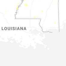
Louisiana
| Local Time | Report Details |
|---|---|
| 2:42 PM CDT | Large branches and tree debris reported down across la 182 between washington and i-49 interchang in st. landry county LA, 27.6 miles N of Lafayette, LA |
| 4:35 PM CDT | Powerline downed near intersection of richardson loop and fairfield roa in grant county LA, 90.8 miles SSW of Bastrop, LA |
| 4:40 PM CDT | Tree down near the intersection of highway 471 and oquinn spu in grant county LA, 86.7 miles SE of Shreveport, LA |
| 4:45 PM CDT | Tree down on liberty chapel roa in grant county LA, 87.5 miles SSW of Bastrop, LA |
| 5:08 PM CDT | Many reports of trees and powerlines down along state route 34 from atlanta to winnfiel in winn county LA, 76.4 miles SE of Shreveport, LA |
| 5:30 PM CDT | 911 operator had many reports of trees and powerlines all over the parish. the main area was from atlanta to winnfiel in winn county LA, 73.1 miles SW of Bastrop, LA |
| 6:20 PM CDT | Report of multiple trees downed in the city and around the county... including a tree that fell on a power line causing a fir in madison county LA, 49.8 miles ESE of Bastrop, LA |
Georgia
| Local Time | Report Details |
|---|---|
| 4:12 PM EDT | Quarter sized hail reported near Chatsworth, GA, 34.6 miles ESE of Chattanooga, TN, 1 inch hail in eton... ga. |
| 4:39 PM EDT | Tree down at hay renfroe dr and laurel farm lan in paulding county GA, 27.3 miles WNW of Atlanta, GA |
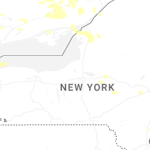
New York
| Local Time | Report Details |
|---|---|
| 4:16 PM EDT | Report of tree down on foxhall avenu in ulster county NY, 61 miles S of Schenectady, NY |
| 4:17 PM EDT | Social media report of trees down on mcentee st off of broadway in kingsto in ulster county NY, 61.6 miles S of Schenectady, NY |
| 5:40 PM EDT | Trees and lines down in the norfolk are in st. lawrence county NY, 25.7 miles ENE of Ogdensburg, NY |
| 5:52 PM EDT | Tree down on county route in franklin county NY, 50.6 miles ENE of Ogdensburg, NY |
| 5:57 PM EDT | Trees on wire in franklin county NY, 42.5 miles W of Burlington, VT |
| 6:05 PM EDT | Tree down blocking entire roadwa in franklin county NY, 56.5 miles E of Ogdensburg, NY |
| 6:33 PM EDT | Numerous reports of trees and wires downed across the city of niagara falls... including some reports of trees downed onto house in niagara county NY, 15.8 miles NNW of Buffalo, NY |
| 6:40 PM EDT | Storm damage reported in loz042 county NY, 32.4 miles NNE of Buffalo, NY |
| 6:47 PM EDT | Numerous reports of trees and wires downed across north tonawanda... including a few reports of trees onto house in niagara county NY, 10.7 miles N of Buffalo, NY |
| 6:48 PM EDT | Tree snapped in half on east stree in erie county NY, 3.9 miles NNW of Buffalo, NY |
| 6:52 PM EDT | Trained spotter reported large tree branches down in tonawanda in the vicinity of ives par in erie county NY, 8.6 miles N of Buffalo, NY |
| 6:54 PM EDT | Trees downed in delaware par in erie county NY, 3.2 miles NNE of Buffalo, NY |
| 7:00 PM EDT | Portion of tree downed on a hous in erie county NY, 6.8 miles NE of Buffalo, NY |
| 7:20 PM EDT | Uprooted tree; time estimated by rada in oneida county NY, 43.1 miles E of Syracuse, NY |
| 7:33 PM EDT | Large tree down over the road. time estimated by rada in oneida county NY, 43.9 miles E of Syracuse, NY |
| 7:38 PM EDT | Report of tree down on center rd in frankfort... n in herkimer county NY, 50.5 miles E of Syracuse, NY |
| 7:45 PM EDT | A few reports of trees downed in gate in monroe county NY, 62.6 miles ENE of Buffalo, NY |
| 7:46 PM EDT | Report of tree down on joslin hill rd in frankfort... n in herkimer county NY, 53.7 miles E of Syracuse, NY |
| 7:54 PM EDT | Reports of trees and wires downed across the city of rocheste in monroe county NY, 66.7 miles ENE of Buffalo, NY |
| 7:55 PM EDT | Large tree down on a vehicle (relayed via social media... with photo). time estimated by rada in madison county NY, 29.1 miles E of Syracuse, NY |
| 8:07 PM EDT | Numerous reports of trees and wires downed in macedo in wayne county NY, 58.4 miles W of Syracuse, NY |
| 8:07 PM EDT | Reports of numerous trees and wires downed in palmyra... including a tree downed onto a hous in wayne county NY, 54.8 miles W of Syracuse, NY |
| 8:10 PM EDT | Trees and wires downed in the town of alexandria bay. time estimated by rada in jefferson county NY, 32.4 miles SW of Ogdensburg, NY |
| 8:10 PM EDT | Trees and wires downed in the town of clayton. time estimated by rada in jefferson county NY, 43.2 miles SW of Ogdensburg, NY |
| 8:12 PM EDT | Photo of thunderstorm wind damaged relayed via social media. time estimated by rada in otsego county NY, 53.3 miles ESE of Syracuse, NY |
| 8:20 PM EDT | Numerous reports of trees and wires downed in newar in wayne county NY, 48.2 miles W of Syracuse, NY |
| 8:24 PM EDT | Numerous reports of trees and wires downed in lyon in wayne county NY, 42.7 miles W of Syracuse, NY |
| 8:26 PM EDT | Numerous reports of trees and wires downed in theres in jefferson county NY, 36.8 miles SSW of Ogdensburg, NY |
| 8:30 PM EDT | Numerous reports of trees and wires downed in clyd in wayne county NY, 36.6 miles W of Syracuse, NY |
| 8:30 PM EDT | Corrects previous tstm wnd dmg report from gouverneur. multiple trees down throughout the tow in st. lawrence county NY, 24.5 miles S of Ogdensburg, NY |
| 8:34 PM EDT | Numerous reports of trees and wires downed in the town of le ra in jefferson county NY, 44.9 miles SSW of Ogdensburg, NY |
| 8:38 PM EDT | Reports of trees and wires downed in the town of granb in oswego county NY, 24.2 miles NW of Syracuse, NY |
| 8:38 PM EDT | Trees and powerlines down in harrisville. delayed report. time estimated from rada in lewis county NY, 38.5 miles SSE of Ogdensburg, NY |
| 8:42 PM EDT | Reports of trees and wires downed in palerm in oswego county NY, 22.4 miles NNW of Syracuse, NY |
| 8:42 PM EDT | Trees and wires downed in the town of volne in oswego county NY, 22.7 miles NNW of Syracuse, NY |
| 8:50 PM EDT | Trees down with wires on phoenix mills road as per county dispatch feed. radar-estimated tim in otsego county NY, 52.3 miles W of Schenectady, NY |
| 8:50 PM EDT | Trees and wires down... maples road. radar estimated tim in otsego county NY, 55.5 miles WSW of Schenectady, NY |
| 9:00 PM EDT | Numerous trees dow in st. lawrence county NY, 28.9 miles ESE of Ogdensburg, NY |
| 9:00 PM EDT | Numerous trees dow in st. lawrence county NY, 25.9 miles ESE of Ogdensburg, NY |
| 9:01 PM EDT | Trees and powerlines down in beaver falls. delayed report. time estimated from rada in lewis county NY, 55.6 miles S of Ogdensburg, NY |
| 9:01 PM EDT | Trees and powerlines down. delayed report. time estimated from rada in lewis county NY, 55 miles S of Ogdensburg, NY |
| 9:04 PM EDT | Tree down on road... near hooker mountain and stanley roseboom roads intersection... as per county dispatch feed. radar-estimated tim in otsego county NY, 48.3 miles WSW of Schenectady, NY |
| 9:14 PM EDT | 12 inch diameter maple tree snapped on suny oneonta campus. relayed via social media. time estimated by rada in otsego county NY, 61.7 miles WSW of Schenectady, NY |
| 9:18 PM EDT | Tree down over state route 28 as per county dispatch feed. radar-estimated time of impac in otsego county NY, 55.2 miles WSW of Schenectady, NY |
| 9:20 PM EDT | Multiple trees down... stonehouse road... as per dispatch fee in otsego county NY, 54.5 miles WSW of Schenectady, NY |
| 9:24 PM EDT | Trees down... blocking axtell road... as per dispatch fee in otsego county NY, 51.8 miles WSW of Schenectady, NY |
| 9:26 PM EDT | Trees down in big moose area. time estimated from rada in herkimer county NY, 66.8 miles SSE of Ogdensburg, NY |
| 9:35 PM EDT | Tree down into a house. caused damage to the residence... including roof damage. time estimated by rada in oneida county NY, 29.7 miles ENE of Syracuse, NY |
| 9:36 PM EDT | Trees and power lines down in the road. time estimated from rada in franklin county NY, 49.9 miles ENE of Ogdensburg, NY |
| 9:42 PM EDT | Several trees down within the schenectady area. time estimated from rada in schenectady county NY, 1.6 miles E of Schenectady, NY |
| 9:45 PM EDT | Large tree down in road. time estimated from rada in franklin county NY, 51.8 miles W of Burlington, VT |
| 9:53 PM EDT | Multiple trees down on elm street in cohoes. time estimated from rada in albany county NY, 12 miles E of Schenectady, NY |
| 9:57 PM EDT | Tree down on calhoun drive. time estimated from rada in rensselaer county NY, 15.3 miles E of Schenectady, NY |
| 10:23 PM EDT | Trees down along ny 22. time estimated from rada in rensselaer county NY, 34.3 miles ESE of Schenectady, NY |
| 10:35 PM EDT | Tree blocking mason street. time estimated from rada in clinton county NY, 22.2 miles NW of Burlington, VT |
| 10:42 PM EDT | Tree down on wires. time estimated from rada in columbia county NY, 37.3 miles SSE of Schenectady, NY |
| 10:54 PM EDT | Tree down on road along county route 2 in washington county NY, 59.5 miles NNE of Schenectady, NY |
| 11:04 PM EDT | Wires down across state route 55 with a transformer fire. time estimated by rada in sullivan county NY, 63.1 miles ENE of Scranton, PA |
North Carolina
| Local Time | Report Details |
|---|---|
| 4:45 PM EDT | Tree blown down onto powerlines south of murph in cherokee county NC, 63.7 miles S of Knoxville, TN |
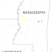
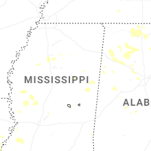
Mississippi
| Local Time | Report Details |
|---|---|
| 4:10 PM CDT | Tree downed on lee stokes rd from outflow winds. likely sub severe wind gus in lowndes county MS, 30.3 miles E of Starkville, MS |
| 4:10 PM CDT | Large tree down across patterson chapel rd south of golde in tishomingo county MS, 37.1 miles SW of Florence, AL |
| 4:15 PM CDT | Several trees down from plantersville to shanno in lee county MS, 48.6 miles N of Starkville, MS |
| 4:15 PM CDT | Large trees down on vehicle in itawamba county MS, 47.2 miles SW of Florence, AL |
| 4:15 PM CDT | Numerous trees and power lines down across town and a few outbuildings suffered significant damage. structural damage to some store fronts and roof in tishomingo county MS, 36.4 miles WSW of Florence, AL |
| 4:25 PM CDT | Corrects previous tstm wnd dmg report from tishomingo. trees and power lines down across the communit in tishomingo county MS, 33.5 miles WSW of Florence, AL |
| 4:30 PM CDT | Numerous trees and power lines down in iuka area due to strong winds associated with a thunderstorm outflow boundar in tishomingo county MS, 29.3 miles W of Florence, AL |
| 4:35 PM CDT | Several trees down along highway 365 and highway 30. one home off of 365 sustained significant damage due to treefal in prentiss county MS, 39.2 miles WSW of Florence, AL |
| 4:45 PM CDT | Tree downed at the 6000 block of hwy 4 in clay county MS, 15 miles N of Starkville, MS |
| 4:55 PM CDT | Large tree down across road 10 in lee county MS, 45.1 miles NNE of Starkville, MS |
| 5:32 PM CDT | Several trees downed in southern oktibbeha c in oktibbeha county MS, 10.1 miles S of Starkville, MS |
| 5:40 PM CDT | Trees and power lines downed along ms hwy 465 at steel bayo in issaquena county MS, 42.8 miles WNW of Jackson, MS |
| 5:45 PM CDT | Several trees downed in western oktibbeha co with power outage in oktibbeha county MS, 12.9 miles WNW of Starkville, MS |
| 5:55 PM CDT | Tree and power lines downed along lagrange r in choctaw county MS, 22.6 miles W of Starkville, MS |
| 6:25 PM CDT | Trees and power lines down across the communit in tishomingo county MS, 33.5 miles WSW of Florence, AL |
| 6:33 PM CDT | Damage occurred to some outbuildings and fences and the front porch of a mobile home was separated from the home along us 61 south of car in sharkey county MS, 53.7 miles NW of Jackson, MS |
| 7:05 PM CDT | Power lines were downed east of anguill in sharkey county MS, 59.4 miles NW of Jackson, MS |
| 7:10 PM CDT | A restaurant sign was blown out along us 6 in sharkey county MS, 58.7 miles NW of Jackson, MS |
| 8:05 PM CDT | Part of a tree was broken in country club estate in washington county MS, 64.3 miles NE of Bastrop, LA |
Texas
| Local Time | Report Details |
|---|---|
| 5:38 PM CDT | 58 mph gust measured at the wt mesonet site 11 miles wnw of bootle in deaf smith county TX, 46.2 miles ESE of Tucumcari, NM |
| 6:48 PM CDT | Friona wt in parmer county TX, 61.9 miles SW of Amarillo, TX |
| 7:00 PM CDT | Friona wt in parmer county TX, 61.9 miles SW of Amarillo, TX |
| 10:10 PM CDT | Severe wind gusts occurred for 2 consecutive minute in armstrong county TX, 48.5 miles ESE of Amarillo, TX |
Tennessee
| Local Time | Report Details |
|---|---|
| 5:59 PM CDT | Tree fell into home on shoally branch road. time estimated from rada in lawrence county TN, 31.9 miles NE of Florence, AL |
| 6:02 PM CDT | Corrects previous tstm wnd dmg report from 6 s lawrenceburg. 911 reported multiple trees down in leoma and se lawrenceburg. time estimated from rada in lawrence county TN, 30.9 miles NE of Florence, AL |
| 6:31 PM CDT | 911 reported multiple trees down in leoma and se lawrenceburg. time estimated from rada in lawrence county TN, 30.9 miles NE of Florence, AL |
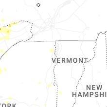
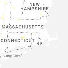
Vermont
| Local Time | Report Details |
|---|---|
| 7:15 PM EDT | Multiple trees and powerlines down in cambridge and underhil in lamoille county VT, 20.4 miles NE of Burlington, VT |
| 7:23 PM EDT | Quarter sized hail reported near Essex Junction, VT, 7.9 miles ENE of Burlington, VT |
| 7:25 PM EDT | Several trees down on raceway roa in chittenden county VT, 12.9 miles ENE of Burlington, VT |
| 7:30 PM EDT | Tree down on cilley hill roa in chittenden county VT, 11.9 miles ENE of Burlington, VT |
| 7:30 PM EDT | Tree down on browns trace roa in chittenden county VT, 13.1 miles E of Burlington, VT |
| 7:52 PM EDT | Trees dow in lamoille county VT, 25.4 miles E of Burlington, VT |
| 7:52 PM EDT | Tree down on power lines on town hill roa in lamoille county VT, 39.8 miles ENE of Burlington, VT |
| 8:06 PM EDT | Trees and powerlines dow in rutland county VT, 52.6 miles SSE of Burlington, VT |
| 8:06 PM EDT | Trees and powerlines dow in rutland county VT, 52.2 miles SSE of Burlington, VT |
| 8:15 PM EDT | Trees and powerlines dow in washington county VT, 31.1 miles ESE of Burlington, VT |
| 8:30 PM EDT | Multiple trees dow in washington county VT, 37.6 miles ESE of Burlington, VT |
| 8:35 PM EDT | Tree down near campu in caledonia county VT, 58.6 miles E of Burlington, VT |
| 8:42 PM EDT | Downed power lines on s wheelock rd. time estimated from rada in caledonia county VT, 56.7 miles E of Burlington, VT |
| 9:05 PM EDT | Trees and wires down on leighton hill road in newbur in orange county VT, 59.9 miles ESE of Burlington, VT |
| 11:23 PM EDT | School house road closed due to downed trees. time estimated from rada in windham county VT, 71.6 miles E of Schenectady, NY |
| 11:31 PM EDT | Portion of vt-107 in bethel closed due to a downed tree across the road. time estimated from rada in windsor county VT, 53.8 miles SSE of Burlington, VT |
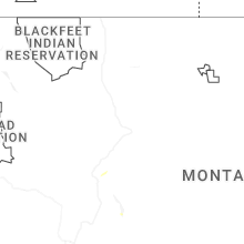
Montana
| Local Time | Report Details |
|---|---|
| 5:45 PM MDT | Mesonet station mthls harlowton south us-191 mp 22. in sweet grass county MT, 62 miles ENE of Bozeman, MT |
| 9:08 PM MDT | Mesonet station ssmm8 devils creek rec area 6ese south sawmill creek... mt (raws - ggw) elev: 3290.0 ft; lat/lon: 47.562140/-107.528 in garfield county MT, 60.4 miles SW of Glasgow, MT |
| 11:00 PM MDT | Scotsman coulee... mt (umt - ggw) elev: 2510.0 ft; lat/lon: 47.9/-106. in mccone county MT, 28 miles SE of Glasgow, MT |
South Dakota
| Local Time | Report Details |
|---|---|
| 6:04 PM MDT | Ping Pong Ball sized hail reported near Rapid City, SD, 5.4 miles N of Rapid City, SD, mainly pea to dime. |
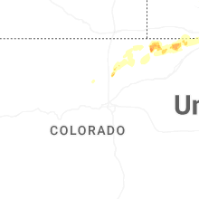
Colorado
| Local Time | Report Details |
|---|---|
| 6:55 PM MDT | Awos station k8v7 3 n springfiel in baca county CO, 102 miles WSW of Garden City, KS |
| 11:41 PM MDT | Asos station kitr burlington co airpor in kit carson county CO, 65.7 miles SSE of Yuma, CO |
| 1:15 AM MDT | Half Dollar sized hail reported near Johnstown, CO, 41.1 miles N of Denver, CO, hail was 2 to 3 inches deep covering the road. |
| 1:29 AM MDT | Quarter sized hail reported near Milliken, CO, 42.6 miles N of Denver, CO, report from mping: quarter (1.00 in.). |
| 2:00 AM MDT | Half Dollar sized hail reported near Johnstown, CO, 41.1 miles N of Denver, CO |
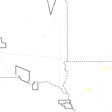
Arkansas
| Local Time | Report Details |
|---|---|
| 8:10 PM CDT | Multiple trees down across the entire count in chicot county AR, 52.5 miles NE of Bastrop, LA |
| 8:50 PM CDT | 1 tree down across highway 8e... and another tree down across highway 82 in ashley county AR, 31.3 miles NNE of Bastrop, LA |
New Hampshire
| Local Time | Report Details |
|---|---|
| 9:12 PM EDT | Corrects previous tstm wnd dmg report from 2 s lancaster. downed tree on reed rd. large branches on wires. time of damage estimated from rada in coos county NH, 81.3 miles E of Burlington, VT |
| 9:20 PM EDT | Corrects previous tstm wnd dmg report from 2 e newbury. two trees down near the airport rd and nh hwy 116 split; reports of power outages. time of damage estimated from in grafton county NH, 64.9 miles ESE of Burlington, VT |
| 9:20 PM EDT | Corrects previous tstm wnd dmg report from 2 n easton. trees down on easton rd north of fall wind farm. time of damage estimated from rada in grafton county NH, 73.6 miles ESE of Burlington, VT |
| 9:25 PM EDT | Corrects previous tstm wnd dmg report from 2 e bradford. observed downed tree partially blocking river rd north of piermont. time of damage estimated from rada in grafton county NH, 64.3 miles ESE of Burlington, VT |
| 9:30 PM EDT | Observed downed tree partially blocking river rd north of piermon in grafton county NH, 64.3 miles ESE of Burlington, VT |
| 9:45 PM EDT | Two trees down near the airport rd and nh hwy 116 split; reports of power outage in grafton county NH, 64.9 miles ESE of Burlington, VT |
| 9:55 PM EDT | Trees down on easton rd north of fall wind far in grafton county NH, 73.6 miles ESE of Burlington, VT |
| 10:00 PM EDT | Downed tree on reed rd. large branches on wire in coos county NH, 81.3 miles E of Burlington, VT |
| 10:05 PM EDT | Lyme fire dept social media photos of a large elm tree on top of a half crushed ca in grafton county NH, 69.5 miles SE of Burlington, VT |
| 11:35 PM EDT | Off-duty ems. numerous trees down in hinsdale. 400+ power outage in cheshire county NH, 73.8 miles E of Schenectady, NY |
| 11:40 PM EDT | Reported by amateur radio. trees down on wires in chesterfiel in cheshire county NH, 72.9 miles E of Schenectady, NY |
Idaho
| Local Time | Report Details |
|---|---|
| 7:15 PM MDT | Mesonet station 3003 d4 idahome interchange i-8 in cassia county ID, 59.6 miles E of Twin Falls, ID |
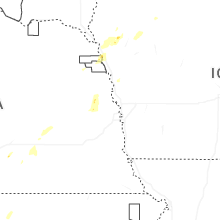
Kansas
| Local Time | Report Details |
|---|---|
| 8:02 PM MDT | Storm damage reported in hamilton county KS, 52.3 miles W of Garden City, KS |
| 8:17 PM MDT | Golf Ball sized hail reported near Syracuse, KS, 47.4 miles W of Garden City, KS |
| 9:24 PM CDT | Quarter sized hail reported near Colby, KS, 1.2 miles SSE of Colby, KS, social media report of quarter size hail. |
| 9:30 PM CDT | Quarter sized hail reported near Colby, KS, 0.3 miles NW of Colby, KS |
| 9:30 PM CDT | Hen Egg sized hail reported near Gem, KS, 8.1 miles ENE of Colby, KS, picture from social media of ~2 inch hail. time approx. from radar. |
| 9:39 PM CDT | Pws kkslakin2 in kearny county KS, 32.1 miles WNW of Garden City, KS |
| 9:40 PM CDT | Storm damage reported in kearny county KS, 29.4 miles WNW of Garden City, KS |
| 10:55 PM CDT | Davis weatherlink station - stappfar in decatur county KS, 53.5 miles NE of Colby, KS |
| 12:55 AM CDT | Report was from a personal awn weather statio in scott county KS, 27.6 miles N of Garden City, KS |
Massachusetts
| Local Time | Report Details |
|---|---|
| 11:10 PM EDT | Large tree and multiple powerlines downed in ashfield. relayed by amateur radi in franklin county MA, 59.7 miles ESE of Schenectady, NY |
| 11:10 PM EDT | Downed powerline wires near apple valley rd in ashfield. relayed by amateur radi in franklin county MA, 60.2 miles ESE of Schenectady, NY |
| 11:28 PM EDT | Tree downed blocking turnpike rd in turners falls. time estimated by rada in franklin county MA, 72 miles ESE of Schenectady, NY |
| 11:30 PM EDT | Downed tree near milemarker 33 on the westbound side of the massachusetts turnpike. relayed by amateur radi in hampden county MA, 68 miles SE of Schenectady, NY |
| 12:25 AM EDT | Tree down blocking intersection of south and pine streets in douglas. relayed by amateur radio. time estimated by rada in worcester county MA, 20.9 miles NW of Providence, RI |
| 12:26 AM EDT | Tree downed partially blocking riedell st in douglas. relayed by amateur radi in worcester county MA, 23.6 miles NW of Providence, RI |
| 12:30 AM EDT | Tree down blocking half of river rd near the uxbridge and millville town line. relayed by amateur radi in worcester county MA, 17.5 miles NW of Providence, RI |
| 12:30 AM EDT | Tree downed on douglas pike at aldrich st near uxbridge. relayed by amateur radi in worcester county MA, 19 miles NW of Providence, RI |
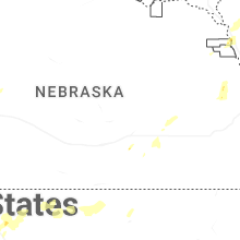
Nebraska
| Local Time | Report Details |
|---|---|
| 11:19 PM MDT | Quarter sized hail reported near Benkelman, NE, 59.2 miles NNW of Colby, KS, mping. |
| 2:31 AM MDT | Personal weather station measured a 60 mph gus in morrill county NE, 51.9 miles ESE of Scottsbluff, NE |
| 3:55 AM CDT | Quarter sized hail reported near Fremont, NE, 31.1 miles WNW of Omaha, NE, report from mping: quarter (1.00 in.). |
| 3:20 AM MDT | Nebraska mesonet lakeside 3n in sheridan county NE, 67.1 miles ENE of Scottsbluff, NE |
| 3:26 AM MDT | Pw in garden county NE, 76.6 miles SE of Scottsbluff, NE |
| 3:31 AM MDT | Pw in deuel county NE, 70.8 miles W of North Platte, NE |
| 3:45 AM MDT | Nebraska mesonet 16ne ellswort in sheridan county NE, 82 miles ENE of Scottsbluff, NE |
Connect with Interactive Hail Maps