

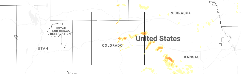
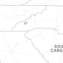
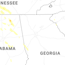
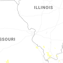
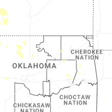
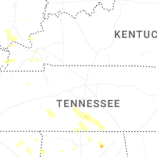
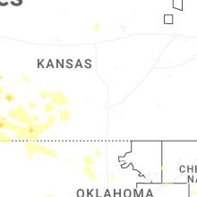
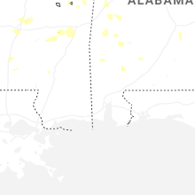
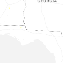
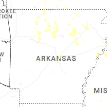
Hail Map for Monday, June 1, 2026
Number of Impacted Households on 6/1/2026
0
Impacted by 1" or Larger Hail
0
Impacted by 1.75" or Larger Hail
0
Impacted by 2.5" or Larger Hail
Square Miles of Populated Area Impacted on 6/1/2026
0
Impacted by 1" or Larger Hail
0
Impacted by 1.75" or Larger Hail
0
Impacted by 2.5" or Larger Hail
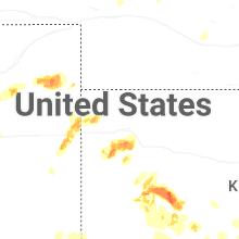
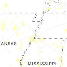

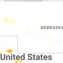
Cities Most Affected by Hail Storms of 6/1/2026
| Hail Size | Demographics of Zip Codes Affected | ||||||
|---|---|---|---|---|---|---|---|
| City | Count | Average | Largest | Pop Density | House Value | Income | Age |
| Bennett, CO | 3 | 1.83 | 2.00 | 16 | $141k | $55.3k | 40.3 |
| Denver, CO | 2 | 1.75 | 1.75 | 5545 | $252k | $36.5k | 34.5 |
| Woodrow, CO | 1 | 2.00 | 2.00 | 1 | $83k | $31.6k | 43.3 |
| Beeler, KS | 1 | 1.75 | 1.75 | 1 | $29k | $35.4k | 49.4 |
| Stinnett, TX | 1 | 1.75 | 1.75 | 1 | $40k | $33.7k | 38.0 |
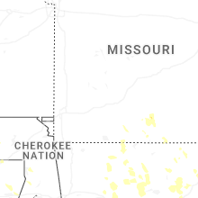
| Mountain Grove, MO | 1 | 1.75 | 1.75 | 33 | $65k | $23.5k | 41.2 |
Hail and Wind Damage Spotted on 6/1/2026
Filter by Report Type:Hail ReportsWind Reports
States Impacted
Kentucky, Kansas, Tennessee, Alabama, Mississippi, Missouri, Colorado, South Carolina, Wyoming, Georgia, Illinois, Iowa, Arkansas, Nebraska, Texas, Oklahoma, Florida, MontanaKentucky
| Local Time | Report Details |
|---|---|
| 7:02 AM CDT | Multiple trees uprooted... several large tree limbs snapped. powerlines down. radar and damage appear consistent with a microburst with peak winds 70-80 mp in marshall county KY, 61.8 miles NNE of Mc Kenzie, TN |
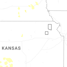
Kansas
| Local Time | Report Details |
|---|---|
| 6:48 AM MDT | Quarter sized hail reported near Goodland, KS, 43.8 miles W of Colby, KS, nickel to quarter size hail. |
| 3:58 PM MDT | Quarter sized hail reported near Goodland, KS, 43.8 miles W of Colby, KS, nickel to quarter size hail reported. |
| 5:00 PM CDT | Quarter sized hail reported near Dighton, KS, 35.3 miles NE of Garden City, KS |
| 4:35 PM MDT | Quarter sized hail reported near Goodland, KS, 48 miles W of Colby, KS, report from mping: quarter (1.00 in.). |
| 4:36 PM MDT | Quarter sized hail reported near Goodland, KS, 47.4 miles W of Colby, KS, pea to quarter size hail. |
| 5:41 PM CDT | Quarter sized hail reported near Healy, KS, 36.3 miles NNE of Garden City, KS |
| 6:07 PM CDT | Storm damage reported in lane county KS, 39.8 miles NE of Garden City, KS |
| 5:10 PM MDT | Asos station kgld goodlan in sherman county KS, 35.1 miles W of Colby, KS |
| 6:15 PM CDT | Quarter sized hail reported near Dighton, KS, 34.8 miles NE of Garden City, KS |
| 6:20 PM CDT | Storm damage reported in lane county KS, 35.3 miles NE of Garden City, KS |
| 6:39 PM CDT | Several trees dow in stanton county KS, 55.3 miles WSW of Garden City, KS |
| 6:00 PM MDT | Camper flipped over. timed estimate in hamilton county KS, 62.2 miles W of Garden City, KS |
| 7:03 PM CDT | Golf Ball sized hail reported near Beeler, KS, 43 miles NE of Garden City, KS |
| 7:16 PM CDT | Storm damage reported in scott county KS, 37.2 miles N of Garden City, KS |
| 7:21 PM CDT | Asos station kgck garden cit in finney county KS, 9 miles ESE of Garden City, KS |
| 7:45 PM CDT | Quarter sized hail reported near Jetmore, KS, 45 miles ENE of Garden City, KS |
| 7:50 PM CDT | Ping Pong Ball sized hail reported near Richfield, KS, 77.1 miles SW of Garden City, KS |
| 7:55 PM CDT | Storm damage reported in gray county KS, 32.9 miles ESE of Garden City, KS |
| 8:05 PM CDT | Storm damage reported in hodgeman county KS, 39.5 miles E of Garden City, KS |
| 8:12 PM CDT | Quarter sized hail reported near Ingalls, KS, 25 miles ESE of Garden City, KS |
| 8:23 PM CDT | Storm damage reported in ford county KS, 49.3 miles ESE of Garden City, KS |
| 8:30 PM CDT | Storm damage reported in ford county KS, 52.6 miles ESE of Garden City, KS |
| 8:46 PM CDT | Storm damage reported in hodgeman county KS, 44.9 miles E of Garden City, KS |
| 8:52 PM CDT | Asos station kddc dodge city regional airpor in ford county KS, 51.2 miles ESE of Garden City, KS |
| 9:09 PM CDT | Storm damage reported in ford county KS, 56.8 miles SE of Garden City, KS |
| 9:15 PM CDT | Mesonet station dw9907 bloo in ford county KS, 59.9 miles ESE of Garden City, KS |
| 9:15 PM CDT | Storm damage reported in ford county KS, 57.3 miles SE of Garden City, KS |
| 9:16 PM CDT | Mesonet station up313 2.1 w minneola (upr in clark county KS, 58.5 miles SE of Garden City, KS |
| 9:16 PM CDT | Storm damage reported in meade county KS, 55.1 miles SE of Garden City, KS |
| 9:30 PM CDT | Storm damage reported in hodgeman county KS, 60.8 miles E of Garden City, KS |
| 10:00 PM CDT | Storm damage reported in ford county KS, 59.4 miles SE of Garden City, KS |
| 10:15 PM CDT | Storm damage reported in kiowa county KS, 79.4 miles S of Hays, KS |
| 10:22 PM CDT | Storm damage reported in kiowa county KS, 80.6 miles N of Woodward, OK |
| 10:42 PM CDT | Storm damage reported in edwards county KS, 70.4 miles S of Hays, KS |
| 10:51 PM CDT | Storm damage reported in edwards county KS, 66.7 miles SSE of Hays, KS |
| 10:51 PM CDT | Storm damage reported in pawnee county KS, 58.1 miles SSE of Hays, KS |
| 11:00 PM CDT | Storm damage reported in stafford county KS, 63.5 miles SSE of Hays, KS |
| 11:33 PM CDT | Storm damage reported in pratt county KS, 82 miles W of Wichita, KS |
| 11:36 PM CDT | Storm damage reported in stafford county KS, 63.5 miles SSE of Hays, KS |
| 11:43 PM CDT | Storm damage reported in pratt county KS, 77.2 miles W of Wichita, KS |
| 12:51 AM CDT | Storm damage reported in kingman county KS, 42.2 miles W of Wichita, KS |
| 1:12 AM CDT | Winds were estimated between 60 and 70 mp in kingman county KS, 32.3 miles WSW of Wichita, KS |
| 1:35 AM CDT | Storm damage reported in sumner county KS, 43.6 miles SSW of Wichita, KS |
| 1:36 AM CDT | Storm damage reported in sumner county KS, 28.1 miles SSW of Wichita, KS |
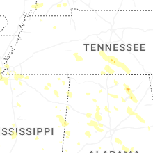
Tennessee
| Local Time | Report Details |
|---|---|
| 11:02 AM CDT | Tree fallen on home on south mill street in linden. time is radar estimate in perry county TN, 52.5 miles SE of Mc Kenzie, TN |
| 11:15 AM CDT | Tree down at intersection of beech creek rd and morrison creek rd. time is radar estimate in wayne county TN, 43.9 miles NNW of Florence, AL |
| 11:45 AM CDT | A large tree branch fell on a ca in lawrence county TN, 34.6 miles NNE of Florence, AL |
| 11:45 AM CDT | Large trees down on 300 block of shady grove r in lincoln county TN, 58 miles W of Chattanooga, TN |
| 12:42 PM CDT | Trees down on pleasant ridge road. power poles are broken due to the trees falling on the in franklin county TN, 55.6 miles W of Chattanooga, TN |
| 12:42 PM CDT | Large tree uprooted at the corner of deer trace road and lovers lan in lincoln county TN, 67.7 miles ENE of Florence, AL |
| 12:45 PM CDT | Multiple trees down within the flintville communit in lincoln county TN, 63 miles W of Chattanooga, TN |
| 3:00 PM EDT | Viewer photo of a large tree down on a metal fence around 3:00 p. in loudon county TN, 22.5 miles WSW of Knoxville, TN |
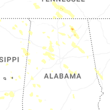
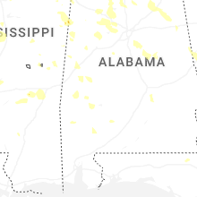
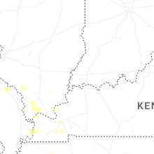
Alabama
| Local Time | Report Details |
|---|---|
| 12:07 PM CDT | Tree down blocking the road on cr 136 at nature chang in lauderdale county AL, 17.8 miles NE of Florence, AL |
| 12:08 PM CDT | Tree down blocking both lanes of the intersection of cr 136 and 3 in lauderdale county AL, 17.8 miles NE of Florence, AL |
| 12:10 PM CDT | Tree down on 200 block of county rd 50 in lauderdale county AL, 22.1 miles ENE of Florence, AL |
| 12:11 PM CDT | Tree fell on a house in the 13000 block of cr 47. other trees down in the vicinit in lauderdale county AL, 14.6 miles NE of Florence, AL |
| 12:17 PM CDT | Tree down at cr 52 at 15 in lauderdale county AL, 25 miles ENE of Florence, AL |
| 12:18 PM CDT | Power lines down at the stop sign across from the store on 7 in lauderdale county AL, 13.4 miles ENE of Florence, AL |
| 12:19 PM CDT | Tree down across the road blocking one lane... pending removal by tracto in lauderdale county AL, 11.8 miles NE of Florence, AL |
| 12:22 PM CDT | Two trees down on cr 530 and 52. caller is stuck between them. no injurie in lauderdale county AL, 25.5 miles ENE of Florence, AL |
| 12:23 PM CDT | Trees down completely covering cr 15 and cr 11 in lauderdale county AL, 9 miles NW of Florence, AL |
| 12:27 PM CDT | Tree down in the roadway blocking both lanes of traffic in the 3000 block of cr 2 in lauderdale county AL, 11.6 miles NE of Florence, AL |
| 12:30 PM CDT | Tree limb hanging and blocking road at intersection of cr 581 and cr 58 in lauderdale county AL, 16.3 miles E of Florence, AL |
| 12:32 PM CDT | Tree down blocking one lane of hwy 64 near the intersection of cr 50 in lauderdale county AL, 23.8 miles ENE of Florence, AL |
| 12:42 PM CDT | Tree down on a house in the 5500 block of cr 130. trees also down on power line in lauderdale county AL, 16.1 miles NE of Florence, AL |
| 12:43 PM CDT | Trees down blocking the road at hwy 157 at cr 23 in lawrence county AL, 17.1 miles SE of Florence, AL |
| 12:47 PM CDT | Tree down blocking both lanes near the intersection of cf 136 and 62 in lauderdale county AL, 18.2 miles NE of Florence, AL |
| 12:50 PM CDT | Metal hay barn destroyed at a farm on snake road at shaw road on the nw side of that intersection. trees down also at this locatio in limestone county AL, 31 miles E of Florence, AL |
| 12:50 PM CDT | Tree laying down on communication lin in morgan county AL, 39.3 miles ESE of Florence, AL |
| 12:58 PM CDT | Large tree down on 2400 block of red bank r in morgan county AL, 46.7 miles ESE of Florence, AL |
| 1:00 PM CDT | Tree down on 1100 block of bird spring r in morgan county AL, 42.9 miles ESE of Florence, AL |
| 1:00 PM CDT | Corrected lsr formatting. trees and power lines down along highway 172 in hacklebur in marion county AL, 37.5 miles SSW of Florence, AL |
| 1:00 PM CDT | Corrected lsr formatting. trees and powerlines down near shottsville on highway 19 and also on downs r in marion county AL, 41.2 miles SSW of Florence, AL |
| 1:00 PM CDT | Large tree and powerlines down across both lanes of road in the 800 block of neel school r in morgan county AL, 41.1 miles ESE of Florence, AL |
| 1:02 PM CDT | Trees down at trademark drive at martin roa in madison county AL, 53.7 miles E of Florence, AL |
| 1:02 PM CDT | Tree down near intersection of eddy rd and kirby bridge rd... blocking roadwa in morgan county AL, 40.1 miles ESE of Florence, AL |
| 1:02 PM CDT | Tree fell and brought down powerlines on neel school rd... near intersection of kirby bridge r in morgan county AL, 39.7 miles ESE of Florence, AL |
| 1:03 PM CDT | Trees down at the intersection of cr 49 and 51 in lauderdale county AL, 25.5 miles ENE of Florence, AL |
| 1:03 PM CDT | Tree down on house and cars on 100 block of still meadow r in morgan county AL, 52.2 miles ESE of Florence, AL |
| 1:04 PM CDT | Tree fall and complete blockage of road at intersection of old hwy 24 and n mountain d in morgan county AL, 36.3 miles ESE of Florence, AL |
| 1:05 PM CDT | Tree down on south bound lane of i-65... about a mile before 328 exi in morgan county AL, 49.7 miles ESE of Florence, AL |
| 1:05 PM CDT | Trees down on a she in limestone county AL, 36.2 miles E of Florence, AL |
| 1:05 PM CDT | Trees down on a house in the 1600 block of runnymead avenu in morgan county AL, 40.3 miles ESE of Florence, AL |
| 1:06 PM CDT | Tree down blocking the roadway in the 300 block of tower stree in morgan county AL, 36.9 miles ESE of Florence, AL |
| 1:06 PM CDT | Tree down on iron man rd... near intersection of wynn wallace r in morgan county AL, 43.1 miles ESE of Florence, AL |
| 1:08 PM CDT | Large tree across bethel rd ne near intersection of indian hills rd n in morgan county AL, 49 miles ESE of Florence, AL |
| 1:09 PM CDT | Power lines down across the roadway; 2600 block of n bethel r in morgan county AL, 47.4 miles ESE of Florence, AL |
| 1:10 PM CDT | Tree down blocking roadway on 300 block of gilchrist rd... powerlines dow in morgan county AL, 55.3 miles ESE of Florence, AL |
| 1:11 PM CDT | Trees down blocking both lanes of cr 35 and 7 in lauderdale county AL, 19.5 miles ENE of Florence, AL |
| 1:15 PM CDT | Trees and power lines down along county highway 122 and also along highway 1 in marion county AL, 53.3 miles SSW of Florence, AL |
| 1:15 PM CDT | Large tree down on pleasant country rd near intersection with s robinson r in morgan county AL, 56.3 miles SE of Florence, AL |
| 1:16 PM CDT | Tree down blocking right late... and partial blockage to the left lan in morgan county AL, 43.1 miles ESE of Florence, AL |
| 1:17 PM CDT | Tree down blocking the road wa in morgan county AL, 47.9 miles ESE of Florence, AL |
| 1:17 PM CDT | Tree down causing total blockage to roa in morgan county AL, 51.1 miles ESE of Florence, AL |
| 1:20 PM CDT | Tree down blocking burney mountain r in morgan county AL, 52.1 miles SE of Florence, AL |
| 1:20 PM CDT | *** 2 inj *** 9 rvs reported to be totaled... large trees down at little mountain mariana; 2 reported injurie in marshall county AL, 64.4 miles SW of Chattanooga, TN |
| 1:20 PM CDT | Tress down across parts of the count in winston county AL, 47.5 miles SSE of Florence, AL |
| 1:26 PM CDT | Tree down across railroad tracks near this nucor tubular products trinit in lawrence county AL, 34 miles ESE of Florence, AL |
| 1:34 PM CDT | Trees down across southbound lanes of hwy 157 in battlegroun in morgan county AL, 51.2 miles SE of Florence, AL |
| 1:34 PM CDT | Tree down blocking the roadway at new bethel road and cypress driv in morgan county AL, 47.2 miles ESE of Florence, AL |
| 1:39 PM CDT | Trees and power lines down along highway 27 in marion county AL, 59.9 miles NE of Starkville, MS |
| 1:44 PM CDT | Tree down blocking part of frost r in morgan county AL, 57.2 miles N of Birmingham, AL |
| 1:48 PM CDT | Tree down on apple grove r in cullman county AL, 54 miles NNE of Birmingham, AL |
| 1:51 PM CDT | Multiple trees and powerlines down countywid in lamar county AL, 45.3 miles ENE of Starkville, MS |
| 1:53 PM CDT | Trees and power lines down on mill creek rd and also on highway in walker county AL, 52.2 miles NW of Birmingham, AL |
| 1:59 PM CDT | Multiple trees down burgett r in blount county AL, 44.1 miles NNE of Birmingham, AL |
| 2:00 PM CDT | Multiple trees down around jaspe in walker county AL, 34.4 miles NW of Birmingham, AL |
| 2:00 PM CDT | Tree on mobile home on highway 7 in blount county AL, 50.3 miles NNE of Birmingham, AL |
| 2:04 PM CDT | Tree down on ripley road in carbon hil in walker county AL, 43.5 miles NW of Birmingham, AL |
| 2:05 PM CDT | Multiple trees and power lines down countywid in fayette county AL, 58.6 miles ENE of Starkville, MS |
| 2:09 PM CDT | Tree down on tumlin gap r in etowah county AL, 46.7 miles NE of Birmingham, AL |
| 2:09 PM CDT | Tree down at highway 31 and county road 5 and along county road in blount county AL, 27.5 miles N of Birmingham, AL |
| 2:09 PM CDT | Tree down gun club roa in fayette county AL, 59.3 miles WNW of Birmingham, AL |
| 2:15 PM CDT | Tree fell on occupied vehicle. no injurie in jefferson county AL, 20 miles N of Birmingham, AL |
| 2:15 PM CDT | Trees down on highway 179 and highway 7 in etowah county AL, 53.1 miles NE of Birmingham, AL |
| 2:15 PM CDT | Carport blown into roadway. other trees down in the are in blount county AL, 35.2 miles NNE of Birmingham, AL |
| 2:15 PM CDT | Trees down in traffor in jefferson county AL, 21.1 miles N of Birmingham, AL |
| 2:20 PM CDT | Tree down on coon creek roa in walker county AL, 23.9 miles NNW of Birmingham, AL |
| 2:20 PM CDT | Multiple trees down around cordova and parris in walker county AL, 27.8 miles NW of Birmingham, AL |
| 2:25 PM CDT | Tree down in whitne in st. clair county AL, 38.5 miles NE of Birmingham, AL |
| 2:25 PM CDT | Tree down valley grove r in blount county AL, 24.3 miles NE of Birmingham, AL |
| 2:25 PM CDT | Tree down sellers r in walker county AL, 20.8 miles NW of Birmingham, AL |
| 2:25 PM CDT | Multiple trees down in gadsde in etowah county AL, 57.6 miles NE of Birmingham, AL |
| 2:29 PM CDT | Multiple trees were downed around fultondale... with several blocked roadways... including kc dement ave... stouts rd... and 34th st in jefferson county AL, 7.6 miles N of Birmingham, AL |
| 2:30 PM CDT | Multiple trees down around highway 231 and highway 14 in st. clair county AL, 33.4 miles ENE of Birmingham, AL |
| 2:30 PM CDT | Trees down pinson valley parkwa in jefferson county AL, 12.2 miles NNE of Birmingham, AL |
| 2:30 PM CDT | Tree blocking roadway highway 11 and frost hollow roa in st. clair county AL, 40.3 miles NE of Birmingham, AL |
| 2:30 PM CDT | Trees down on lister ferry rd and also steele station r in etowah county AL, 50 miles ENE of Birmingham, AL |
| 2:30 PM CDT | Multiple trees down in pinso in jefferson county AL, 13.6 miles NNE of Birmingham, AL |
| 2:35 PM CDT | Large tree down on bankhead highwa in jefferson county AL, 10.2 miles WNW of Birmingham, AL |
| 2:39 PM CDT | Multiple trees down around odenvill in st. clair county AL, 26.2 miles ENE of Birmingham, AL |
| 2:42 PM CDT | Tree down alliance r in jefferson county AL, 18.4 miles W of Birmingham, AL |
| 2:42 PM CDT | Tree down on valley rd near the pinnacl in jefferson county AL, 11.7 miles ENE of Birmingham, AL |
| 2:45 PM CDT | Tree down in reform. also a tree down in carrolto in pickens county AL, 46.2 miles E of Starkville, MS |
| 2:49 PM CDT | Tree down blocking one lane at caldwell mill and camp horner roa in jefferson county AL, 8.1 miles SSE of Birmingham, AL |
| 2:49 PM CDT | Multiple trees down graham driv in calhoun county AL, 55.6 miles ENE of Birmingham, AL |
| 2:50 PM CDT | Trees down in vestavia hill in jefferson county AL, 5.4 miles SSE of Birmingham, AL |
| 2:51 PM CDT | Rocky ridge road at lochridge road tree down with power pole and transformer dow in jefferson county AL, 7.8 miles SSE of Birmingham, AL |
| 2:54 PM CDT | Tree downed onto a hous in jefferson county AL, 12.4 miles SW of Birmingham, AL |
| 2:54 PM CDT | Trees down along lakeshore parkway and green spring in jefferson county AL, 4.2 miles S of Birmingham, AL |
| 2:57 PM CDT | Multiple trees down around cropwel in st. clair county AL, 30.8 miles E of Birmingham, AL |
| 3:00 PM CDT | Multiple trees down around talladega and lincol in talladega county AL, 39.4 miles E of Birmingham, AL |
| 3:00 PM CDT | Tree on a house avenue k in brighto in jefferson county AL, 8.8 miles SW of Birmingham, AL |
| 3:00 PM CDT | Tree on a house howard stree in talladega county AL, 40.3 miles E of Birmingham, AL |
| 3:00 PM CDT | Tree down at sunny meadows dr and cahaba valley trac in shelby county AL, 11.3 miles SSE of Birmingham, AL |
| 3:00 PM CDT | Tree fell on a mobile hom in jefferson county AL, 13.8 miles SW of Birmingham, AL |
| 3:00 PM CDT | Multiple trees down on peaceburg rd in weave in calhoun county AL, 60.2 miles ENE of Birmingham, AL |
| 3:00 PM CDT | Multiple trees down on choccolocco road in annisto in calhoun county AL, 60.1 miles E of Birmingham, AL |
| 3:02 PM CDT | Multiple trees down around jacksonville and service station canopy damge in calhoun county AL, 64 miles ENE of Birmingham, AL |
| 3:03 PM CDT | Multiple reports of downed trees in tuscaloosa count in tuscaloosa county AL, 48 miles WSW of Birmingham, AL |
| 3:09 PM CDT | Multiple trees down on morgan rd including on a vehicle near county road 1 in shelby county AL, 17.2 miles SSW of Birmingham, AL |
| 3:09 PM CDT | Trees down south shades crest and bluff ridge r in shelby county AL, 20.4 miles SSW of Birmingham, AL |
| 3:12 PM CDT | Trees down in alabaster and helen in shelby county AL, 18.8 miles S of Birmingham, AL |
| 3:12 PM CDT | Few snapped tress along cr 33 in shelby county AL, 20.2 miles SSE of Birmingham, AL |
| 3:15 PM CDT | Tree on a mobile home in woodstoc in bibb county AL, 29 miles SW of Birmingham, AL |
| 3:15 PM CDT | Tree on a mobile home on peavine stree in shelby county AL, 18 miles S of Birmingham, AL |
| 3:15 PM CDT | Tree on a house heather lan in shelby county AL, 22.1 miles S of Birmingham, AL |
| 3:16 PM CDT | Trees fell and crushed a camper and other trees fell across roadways in the alpine are in talladega county AL, 35.6 miles ESE of Birmingham, AL |
| 3:21 PM CDT | Tree down in alicevill in pickens county AL, 44.3 miles ESE of Starkville, MS |
| 3:21 PM CDT | Multiple trees and power lines down across the count in cleburne county AL, 69.4 miles W of Atlanta, GA |
| 3:25 PM CDT | Trees down around montevall in shelby county AL, 29.1 miles S of Birmingham, AL |
| 3:25 PM CDT | Trees down around columbiana and wilsonvill in shelby county AL, 27.7 miles SE of Birmingham, AL |
| 3:27 PM CDT | Multiple trees down around caler in shelby county AL, 28.4 miles S of Birmingham, AL |
| 3:30 PM CDT | Multiple trees down south river roa in shelby county AL, 32.4 miles SE of Birmingham, AL |
| 3:33 PM CDT | Trees down around ashland and lineville... including country club road and also springhill r in clay county AL, 49.3 miles NNW of Auburn, AL |
| 3:33 PM CDT | Multiple trees down around millerville... including on highway 148 and highway in clay county AL, 47.9 miles NNW of Auburn, AL |
| 3:35 PM CDT | Multiple trees and power lines down cedar creek roa in talladega county AL, 33.4 miles SE of Birmingham, AL |
| 3:35 PM CDT | Tree down on an unoccupied vehicle on school stree in talladega county AL, 39.5 miles ESE of Birmingham, AL |
| 3:39 PM CDT | Multiple trees and power lines down countywid in bibb county AL, 43.9 miles SSW of Birmingham, AL |
| 3:39 PM CDT | Trees down in various parts of northern hale county... some blocking road in hale county AL, 63.4 miles SW of Birmingham, AL |
| 3:45 PM CDT | Quarter sized hail reported near Goodwater, AL, 49.1 miles NW of Auburn, AL |
| 3:51 PM CDT | Trees down around woodlan in randolph county AL, 54.3 miles N of Auburn, AL |
| 3:51 PM CDT | Multiple trees down around wedowe in randolph county AL, 48.4 miles N of Auburn, AL |
| 3:54 PM CDT | Multiple trees down around alexander city... including one on a vehicl in tallapoosa county AL, 36.1 miles NW of Auburn, AL |
| 3:54 PM CDT | Multiple trees and power lines down countywid in chilton county AL, 47.9 miles SSE of Birmingham, AL |
| 3:54 PM CDT | Several trees down across the count in greene county AL, 68.1 miles NNW of Camden, AL |
| 3:55 PM CDT | Tree down on power line in randolph county AL, 42.4 miles N of Auburn, AL |
| 3:56 PM CDT | Multiple trees down around wadle in randolph county AL, 35.7 miles N of Auburn, AL |
| 4:00 PM CDT | Multiple trees and power lines down countywid in coosa county AL, 47.2 miles WNW of Auburn, AL |
| 4:01 PM CDT | Tree down at cr 237... cr 158 intersectio in chambers county AL, 33.3 miles N of Auburn, AL |
| 4:06 PM CDT | Tree down on williams r in sumter county AL, 60.6 miles SE of Starkville, MS |
| 4:11 PM CDT | A tree fell through a home in titu in elmore county AL, 46.2 miles W of Auburn, AL |
| 4:13 PM CDT | Trees down across parts of the count in chambers county AL, 20.7 miles NNE of Auburn, AL |
| 4:15 PM CDT | Multiple trees and power lines down across the county... with the worst damage in northern portions of the count in autauga county AL, 58.8 miles W of Auburn, AL |
| 4:15 PM CDT | Tree on a house in dadevill in tallapoosa county AL, 22.3 miles NW of Auburn, AL |
| 4:18 PM CDT | Multiple trees down around deatsvill in elmore county AL, 53.6 miles W of Auburn, AL |
| 4:20 PM CDT | Two trees down with one lane blocke in chambers county AL, 16.3 miles N of Auburn, AL |
| 4:21 PM CDT | Multiple trees and power lines down across the count in perry county AL, 43.9 miles N of Camden, AL |
| 4:27 PM CDT | Damage to porch overhang on andrew mills r in elmore county AL, 26.3 miles WNW of Auburn, AL |
| 4:30 PM CDT | Multiple trees down wetumpk in elmore county AL, 42.2 miles W of Auburn, AL |
| 4:37 PM CDT | Trees and power lines down around tallasse in elmore county AL, 25 miles WSW of Auburn, AL |
| 4:39 PM CDT | Tree down on mundy road and also a tree down on county road 2 in sumter county AL, 57 miles NW of Camden, AL |
| 4:42 PM CDT | Tree down on county road 2 in sumter county AL, 69.7 miles SSE of Starkville, MS |
| 4:44 PM CDT | Trees down in various parts of the count in lee county AL, 0.2 miles NNE of Auburn, AL |
| 4:54 PM CDT | Multiple trees and power lines down across the count in macon county AL, 17.7 miles SW of Auburn, AL |
| 5:04 PM CDT | Multiple trees and power lines down across primarily the southern half of montgomery count in montgomery county AL, 55.5 miles ENE of Camden, AL |
| 5:11 PM CDT | Trees down sandfort rd and woodland driv in russell county AL, 26.3 miles ESE of Auburn, AL |
| 5:11 PM CDT | Trees down camp parkman r in russell county AL, 24.3 miles ESE of Auburn, AL |
| 5:14 PM CDT | Tree down on power line and on fire cutrate road and opelik in russell county AL, 26.3 miles ESE of Auburn, AL |
| 5:15 PM CDT | Multiple trees and power lines down across the county... especially in the fort deposit and letohatchee area in lowndes county AL, 41.7 miles E of Camden, AL |
| 5:21 PM CDT | Multiple trees and power lines down across the county... including along highway 110... highway 82... and highway 2 in bullock county AL, 35.1 miles SSW of Auburn, AL |
| 5:24 PM CDT | Trees down old seale highway and mt zion stree in russell county AL, 27.9 miles SE of Auburn, AL |
| 5:53 PM CDT | Numerous trees were reported down along the alabama river in the eureka landing community in monroe county... al in monroe county AL, 47.1 miles SSW of Camden, AL |
| 5:54 PM CDT | Multiple trees and power lines down across the county... including on highway 23 in pike county AL, 64.3 miles SSW of Auburn, AL |
| 6:00 PM CDT | Multiple trees and power lines down across the count in barbour county AL, 50.9 miles S of Auburn, AL |
| 6:20 PM CDT | Numerous trees reported down across dale count in dale county AL, 77.6 miles S of Auburn, AL |
| 6:20 PM CDT | Trees reported down north of enterprise in coffee count in coffee county AL, 75.1 miles NNE of Miramar Beach, FL |
| 6:24 PM CDT | Tree reported down on martin luther king jr ave in ozar in dale county AL, 79.7 miles S of Auburn, AL |
| 6:35 PM CDT | A few trees reported down in and around the opp community in covington county... a in covington county AL, 62.6 miles N of Miramar Beach, FL |
| 6:36 PM CDT | Multiple trees reported down on cr 57 near abbevill in henry county AL, 70.6 miles SSE of Auburn, AL |
| 6:38 PM CDT | Numerous trees and power outages reported in dale count in dale county AL, 79 miles NE of Miramar Beach, FL |
| 6:41 PM CDT | Multiple trees reported down in headlan in henry county AL, 86.4 miles S of Auburn, AL |
| 6:45 PM CDT | Tree reported down on cr 14 near midland cit in dale county AL, 83.2 miles NE of Miramar Beach, FL |
| 6:50 PM CDT | Tree reported down on powerlines near national road hom in houston county AL, 80.7 miles NE of Miramar Beach, FL |
| 6:59 PM CDT | Powerlines reported down in gordo in houston county AL, 68.6 miles NW of Tallahassee, FL |
| 7:12 PM CDT | Tree reported down in samso in geneva county AL, 53.9 miles NNE of Miramar Beach, FL |
| 7:22 PM CDT | Reports of trees down blocking roads along with broken power poles and lines across the road between the yarbo and millry communities. reports via the yarbo fire depart in washington county AL, 62.4 miles WSW of Camden, AL |
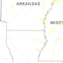
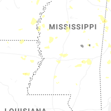
Mississippi
| Local Time | Report Details |
|---|---|
| 12:17 PM CDT | Quarter sized hail reported near Marietta, MS, 52.3 miles WSW of Florence, AL |
| 12:33 PM CDT | Trees down in ratliff communit in itawamba county MS, 56.3 miles WSW of Florence, AL |
| 1:50 PM CDT | Corrects previous tstm wnd dmg report from 1 s flint hill. several trees blown down reported by red cros in lowndes county MS, 34.7 miles ENE of Starkville, MS |
| 2:12 PM CDT | Tree down along hwy 12 at caldwell r in lowndes county MS, 31.1 miles ENE of Starkville, MS |
| 2:34 PM CDT | Several trees blown down reported by red cros in lowndes county MS, 34.7 miles ENE of Starkville, MS |
| 6:14 PM CDT | Madison pd reported several trees down near the lost rabbit community and along rice roa in madison county MS, 13.2 miles NNE of Jackson, MS |
| 6:23 PM CDT | Quarter sized hail reported near Brandon, MS, 19.7 miles NE of Jackson, MS |
| 6:44 PM CDT | Ping Pong Ball sized hail reported near Olive Branch, MS, 18 miles SE of Memphis, TN, reports of nickel to ping pong ball size hail in olive branch. |
| 8:19 PM CDT | Quarter sized hail reported near Coldwater, MS, 31.3 miles S of Memphis, TN |
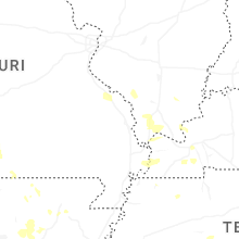
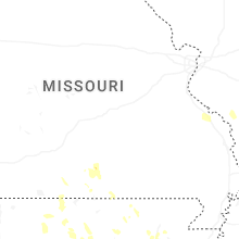
Missouri
| Local Time | Report Details |
|---|---|
| 2:00 PM CDT | Golf Ball sized hail reported near Mountain Grove, MO, 58.4 miles SW of Salem, MO, report of golf ball sized hail at highway 76 and highway ee. time estimated from radar. |
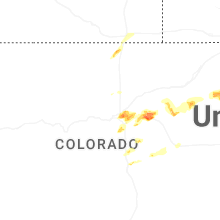
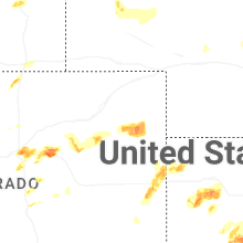
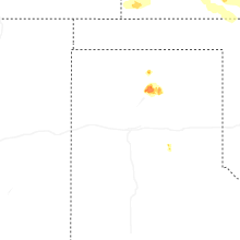
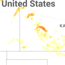
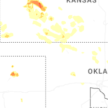
Colorado
| Local Time | Report Details |
|---|---|
| 1:05 PM MDT | Quarter sized hail reported near Colorado Springs, CO, 47.8 miles N of Pueblo, CO |
| 1:05 PM MDT | Quarter sized hail reported near Denver, CO, 2.6 miles WNW of Denver, CO |
| 1:07 PM MDT | Quarter sized hail reported near Denver, CO, 0.1 miles E of Denver, CO |
| 1:08 PM MDT | Quarter sized hail reported near Peyton, CO, 43.5 miles N of Pueblo, CO |
| 1:10 PM MDT | Quarter sized hail reported near Denver, CO, 1.5 miles W of Denver, CO |
| 1:10 PM MDT | Golf Ball sized hail reported near Denver, CO, 0.8 miles NNW of Denver, CO |
| 1:11 PM MDT | Quarter sized hail reported near Denver, CO, 0.9 miles SE of Denver, CO, report from mping: quarter (1.00 in.). |
| 1:11 PM MDT | Quarter sized hail reported near Colorado Springs, CO, 49.9 miles N of Pueblo, CO, report from mping: quarter (1.00 in.). |
| 1:12 PM MDT | Quarter sized hail reported near Colorado Springs, CO, 49.3 miles N of Pueblo, CO |
| 1:14 PM MDT | Ping Pong Ball sized hail reported near Denver, CO, 1.4 miles ESE of Denver, CO |
| 1:15 PM MDT | Quarter sized hail reported near Denver, CO, 0.9 miles SE of Denver, CO, most hail was smaller. |
| 1:15 PM MDT | Quarter sized hail reported near Colorado Springs, CO, 48.8 miles N of Pueblo, CO |
| 1:19 PM MDT | Quarter sized hail reported near Denver, CO, 3.8 miles E of Denver, CO, report from mping: quarter (1.00 in.). |
| 1:22 PM MDT | Golf Ball sized hail reported near Denver, CO, 3.9 miles E of Denver, CO |
| 1:23 PM MDT | Quarter sized hail reported near Denver, CO, 3.8 miles E of Denver, CO, report from mping: quarter (1.00 in.). |
| 1:28 PM MDT | Half Dollar sized hail reported near Denver, CO, 2.2 miles E of Denver, CO, report from mping: half dollar (1.25 in.). |
| 1:31 PM MDT | Ping Pong Ball sized hail reported near Littleton, CO, 13.9 miles S of Denver, CO |
| 1:33 PM MDT | Quarter sized hail reported near Denver, CO, 2 miles NW of Denver, CO, report from mping: quarter (1.00 in.). |
| 1:34 PM MDT | Half Dollar sized hail reported near Larkspur, CO, 42.1 miles SSE of Denver, CO, report from mping: half dollar (1.25 in.). |
| 1:40 PM MDT | Quarter sized hail reported near Aurora, CO, 7.2 miles E of Denver, CO, report from mping: quarter (1.00 in.). |
| 2:05 PM MDT | Half Dollar sized hail reported near Aurora, CO, 9.2 miles E of Denver, CO, report from mping: half dollar (1.25 in.). |
| 2:32 PM MDT | Quarter sized hail reported near Watkins, CO, 21.4 miles ESE of Denver, CO, report from mping: quarter (1.00 in.). |
| 2:34 PM MDT | Quarter sized hail reported near Aurora, CO, 17.4 miles E of Denver, CO |
| 2:41 PM MDT | Quarter sized hail reported near Watkins, CO, 21.4 miles E of Denver, CO, report from mping: quarter (1.00 in.). |
| 2:48 PM MDT | Quarter sized hail reported near Bennett, CO, 27.8 miles E of Denver, CO, report from mping: quarter (1.00 in.). |
| 3:02 PM MDT | Half Dollar sized hail reported near Bennett, CO, 29.4 miles E of Denver, CO, report from mping: half dollar (1.25 in.). |
| 3:03 PM MDT | Golf Ball sized hail reported near Bennett, CO, 27.3 miles E of Denver, CO |
| 3:08 PM MDT | Ping Pong Ball sized hail reported near Bennett, CO, 31 miles E of Denver, CO, report from mping: ping pong ball (1.50 in.). |
| 3:10 PM MDT | Hen Egg sized hail reported near Bennett, CO, 31 miles E of Denver, CO |
| 3:12 PM MDT | Golf Ball sized hail reported near Bennett, CO, 31 miles E of Denver, CO, report from mping: golf ball (1.75 in.). |
| 3:34 PM MDT | Ping Pong Ball sized hail reported near Strasburg, CO, 35.8 miles E of Denver, CO |
| 3:38 PM MDT | Quarter sized hail reported near Carr, CO, 42.1 miles SE of Laramie, WY |
| 4:13 PM MDT | Quarter sized hail reported near Calhan, CO, 59.6 miles SE of Denver, CO, report from mping: quarter (1.00 in.). |
| 4:21 PM MDT | Hen Egg sized hail reported near Woodrow, CO, 40.2 miles WSW of Yuma, CO, report from mping: hen egg (2.00 in.). |
| 4:30 PM MDT | Quarter sized hail reported near Monument, CO, 44.6 miles S of Denver, CO, report from mping: quarter (1.00 in.). |
| 4:30 PM MDT | Ping Pong Ball sized hail reported near Monument, CO, 43 miles S of Denver, CO |
| 4:34 PM MDT | Ping Pong Ball sized hail reported near Monument, CO, 43.4 miles S of Denver, CO, report from social media with image of measured hail stone. |
| 4:35 PM MDT | Quarter sized hail reported near Monument, CO, 43.1 miles S of Denver, CO, report from mping: quarter (1.00 in.). |
| 4:36 PM MDT | Quarter sized hail reported near Monument, CO, 43.4 miles S of Denver, CO |
| 4:36 PM MDT | Quarter sized hail reported near Wray, CO, 26.3 miles E of Yuma, CO, pea to quarter size hail reported by trained spotter. |
| 4:39 PM MDT | Half Dollar sized hail reported near Simla, CO, 64 miles SE of Denver, CO, report from mping: half dollar (1.25 in.). |
| 4:54 PM MDT | Quarter sized hail reported near Elizabeth, CO, 34.8 miles SE of Denver, CO, report from mping: quarter (1.00 in.). |
| 4:56 PM MDT | Ping Pong Ball sized hail reported near Simla, CO, 65.6 miles SE of Denver, CO |
| 5:05 PM MDT | Quarter sized hail reported near Burlington, CO, 55.7 miles SSE of Yuma, CO, estimated report of 1 inch hail 6 north of burlington. |
| 5:40 PM MDT | Quarter sized hail reported near Limon, CO, 77.1 miles ESE of Denver, CO |
| 6:07 PM MDT | Quarter sized hail reported near Yuma, CO, 5.5 miles E of Yuma, CO, report from mping: quarter (1.00 in.). |
| 6:14 PM MDT | Semi blown over at the intersection of cr u and hwy 34. no information regarding injurie in yuma county CO, 13.5 miles E of Yuma, CO |
| 6:28 PM MDT | Mesonet station co048 us 385 holyok in phillips county CO, 33 miles NE of Yuma, CO |
| 6:43 PM MDT | Weatherlin in yuma county CO, 31.6 miles ENE of Yuma, CO |
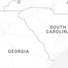
South Carolina
| Local Time | Report Details |
|---|---|
| 3:12 PM EDT | Tree down on hom in oconee county SC, 25.3 miles WSW of Greenville, SC |
| 3:12 PM EDT | Tree down at intersection of engelhard dr and n strawberry farm rd. time estimated from rada in oconee county SC, 24 miles WSW of Greenville, SC |
| 3:12 PM EDT | Quarter sized hail reported near Seneca, SC, 23.8 miles WSW of Greenville, SC, quarter size hail. time estimated from radar. |
| 3:14 PM EDT | Tree down on return church rd at oak creek rd. time estimate in oconee county SC, 27.1 miles WSW of Greenville, SC |
| 3:16 PM EDT | Tree down on roa in oconee county SC, 25.1 miles WSW of Greenville, SC |
| 3:24 PM EDT | Tree down at intersection of sitton shoals rd and sitton mill rd. time estimated from rada in oconee county SC, 25.1 miles SW of Greenville, SC |
| 5:56 PM EDT | Trees down in the 900 block of daves roa in york county SC, 29.5 miles SW of Charlotte, NC |
| 6:03 PM EDT | Trees down in the 3600 block of williamson r in york county SC, 30 miles SSW of Charlotte, NC |
| 11:50 PM EDT | Amateur radio operator relayed report of fallen tree downing power lines along hatchaway bridge rd at fox pond r in aiken county SC, 24.1 miles ENE of Augusta, GA |
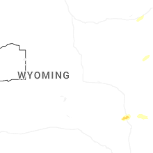
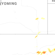
Wyoming
| Local Time | Report Details |
|---|---|
| 1:13 PM MDT | Quarter sized hail reported near Wheatland, WY, 52.9 miles NNE of Laramie, WY, trained spotter reports quarter size hail near wheatland reservoir number 1. |
| 1:30 PM MDT | Quarter sized hail reported near Wheatland, WY, 60.5 miles NNE of Laramie, WY, trained spotter reports quarter size hail in wheatland as well as minor ponding of water on roads. |
| 1:58 PM MDT | Wydot sensor along interstate 25 gust 60 mp in platte county WY, 54.4 miles NE of Laramie, WY |
| 2:26 PM MDT | Quarter sized hail reported near Lingle, WY, 41.3 miles WNW of Scottsbluff, NE, emergency manager reports quarter size hail. |
| 2:29 PM MDT | Quarter sized hail reported near Fort Laramie, WY, 50 miles WNW of Scottsbluff, NE, emergency manager reports lots of quarter size hail. |
| 3:02 PM MDT | Quarter sized hail reported near Veteran, WY, 37.6 miles W of Scottsbluff, NE, report of quarter size hail. |
| 3:50 PM MDT | Quarter sized hail reported near Cheyenne, WY, 41.4 miles ESE of Laramie, WY, trained spotter reports quarter sized hail along interstate 25. |
| 3:56 PM MDT | Quarter sized hail reported near Cheyenne, WY, 43 miles ESE of Laramie, WY, report from mping: quarter (1.00 in.). |
| 4:00 PM MDT | Quarter sized hail reported near Cheyenne, WY, 44.6 miles ESE of Laramie, WY, report from mping: quarter (1.00 in.). |
| 4:02 PM MDT | Quarter sized hail reported near Cheyenne, WY, 41.7 miles ESE of Laramie, WY, report from mping: quarter (1.00 in.). |
| 4:16 PM MDT | Quarter sized hail reported near Cheyenne, WY, 45.5 miles ESE of Laramie, WY |
Georgia
| Local Time | Report Details |
|---|---|
| 3:47 PM EDT | Numerous social media reports of downed and uprooted trees in reed creek. time estimated from rada in hart county GA, 32 miles SW of Greenville, SC |
| 4:00 PM EDT | Firefighter reported trees down on old 29 highwa in hart county GA, 34.9 miles SSW of Greenville, SC |
| 4:04 PM EDT | Firefighter reported trees and powerlines down on milford roa in hart county GA, 36.1 miles SSW of Greenville, SC |
| 4:04 PM EDT | Firefighter reported trees down on anderson highwa in hart county GA, 37 miles SSW of Greenville, SC |
| 4:07 PM EDT | Tree down in 4300 block of cokesbury hw in hart county GA, 40.1 miles SSW of Greenville, SC |
| 4:15 PM EDT | County official reported roof of a church was blown of in elbert county GA, 40.8 miles SSW of Greenville, SC |
| 4:16 PM EDT | Firefighter reported trees and powerlines down on montevideo roa in elbert county GA, 39.6 miles SSW of Greenville, SC |
| 4:30 PM EDT | County official reported trees down on william smith roa in elbert county GA, 45.5 miles SSW of Greenville, SC |
| 4:38 PM EDT | County official reported trees down on harpers ferry roa in elbert county GA, 47 miles S of Greenville, SC |
| 4:56 PM EDT | 911 call center reported trees down near the intersection of lincolnton highway and welcome church roa in elbert county GA, 54.3 miles NW of Augusta, GA |
| 5:42 PM EDT | Tree damage near west point road and bradfield drive with numerous large branches and few a trees down. power lines were knocked down by falling tree which landed on a in troup county GA, 36.4 miles NE of Auburn, AL |
| 5:42 PM EDT | Emergency manager reports 40+ trees down across county from west point lake to lagrange and points southwar in troup county GA, 37.3 miles NE of Auburn, AL |
| 6:18 PM EDT | Ga power shows several thousand customers across the county without power from south of pine mountain to hamilton and surrounding communitie in harris county GA, 36.6 miles ENE of Auburn, AL |
| 6:18 PM EDT | Numerous trees down near ga hwy 116 and lower blue springs rd. one tree fell into a roo in harris county GA, 35.3 miles ENE of Auburn, AL |
| 6:20 PM EDT | Public reports a large tree down along highway 2 in harris county GA, 38.8 miles ENE of Auburn, AL |
| 6:42 PM EDT | Ga power reports several customers without power in and around the midland communit in muscogee county GA, 38.2 miles E of Auburn, AL |
| 7:25 PM EDT | Several trees reported down around benevolenc in randolph county GA, 66.3 miles SE of Auburn, AL |
| 7:54 PM EDT | Trees reported down over sr 39 at old river r in early county GA, 82.3 miles SSE of Auburn, AL |
| 8:15 PM EDT | Tree reported down on s bridge rd in morga in calhoun county GA, 78.1 miles NNW of Tallahassee, FL |
Illinois
| Local Time | Report Details |
|---|---|
| 4:30 PM CDT | Relayed by wcia-t in shelby county IL, 41.5 miles WSW of Mattoon, IL |
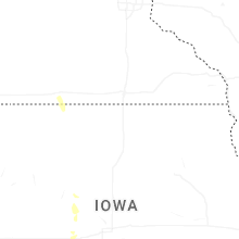
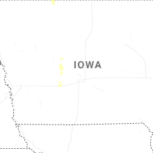
Iowa
| Local Time | Report Details |
|---|---|
| 5:25 PM CDT | Several trees and power lines down. time estimated from radar and personal weather station in greene county IA, 49.4 miles NW of Des Moines, IA |
| 5:26 PM CDT | Strong winds caused tree damage blocking roads. time estimated from rada in greene county IA, 49.8 miles NW of Des Moines, IA |
| 5:31 PM CDT | Quarter sized hail reported near Jefferson, IA, 45.9 miles WNW of Des Moines, IA, mostly dime size but some hail stones as large as a quarter. |
| 5:50 PM CDT | Limbs and tree down. window blown out. time estimated from rada in dallas county IA, 29.2 miles NW of Des Moines, IA |
| 5:58 PM CDT | Large 2ft diameter tree spli in guthrie county IA, 40.2 miles WNW of Des Moines, IA |
| 5:59 PM CDT | Power pole down. blown to southwes in guthrie county IA, 40 miles WNW of Des Moines, IA |
| 6:00 PM CDT | Large pine tree dow in guthrie county IA, 40 miles WNW of Des Moines, IA |
| 6:00 PM CDT | Several branches with one larger tree approx 8 inches in diameter down. several shingles blown off roo in guthrie county IA, 39.5 miles WNW of Des Moines, IA |
Arkansas
| Local Time | Report Details |
|---|---|
| 5:30 PM CDT | An oak tree was uprooted and fell on a house. the roof sustained structural damag in independence county AR, 80.6 miles NNE of Little Rock, AR |
| 6:01 PM CDT | Corrects previous tstm wnd dmg report from 1 ese rosie. multiple trees blown down along arkansas 14 and the updated location is evident via power outage ma in independence county AR, 76 miles NE of Little Rock, AR |
| 6:42 PM CDT | Quarter sized hail reported near Clinton, AR, 62.2 miles N of Little Rock, AR |
| 8:09 PM CDT | Multiple trees down across russellville in addition to london and north of londo in pope county AR, 64.3 miles NW of Little Rock, AR |
| 8:30 PM CDT | Numerous trees down in the area with widespread power outages. winds estimated to be in excess of 70 mph and possibly higher to the eas in pulaski county AR, 7.5 miles S of Little Rock, AR |
| 8:33 PM CDT | Powerlines down 2.2 miles west wrightsvill in pulaski county AR, 9.7 miles S of Little Rock, AR |
Nebraska
| Local Time | Report Details |
|---|---|
| 4:41 PM MDT | Upr site gust 61 mp in scotts bluff county NE, 4 miles W of Scottsbluff, NE |
| 5:38 PM MDT | Quarter sized hail reported near Angora, NE, 34.2 miles E of Scottsbluff, NE, report from mping: quarter (1.00 in.). |
| 6:43 PM MDT | Storm damage reported in garden county NE, 63.5 miles E of Scottsbluff, NE |
| 2:34 AM CDT | Quarter sized hail reported near Lincoln, NE, 54.2 miles SW of Omaha, NE |
Texas
| Local Time | Report Details |
|---|---|
| 5:48 PM CDT | Ping Pong Ball sized hail reported near , , 45.6 miles NNE of Amarillo, TX, public estimated ping pong sized hail at grandview rv park west of stinnett at 5:48 pm. |
| 6:20 PM CDT | Golf Ball sized hail reported near Stinnett, TX, 52.4 miles NNE of Amarillo, TX, hailstones up to golf ball sized were reported 5 miles north of stinnett off of hwy 207. |
| 6:24 PM CDT | Quarter sized hail reported near Stinnett, TX, 53.9 miles NNE of Amarillo, TX, mostly pea to penny size hail with a few quarter size hailstones mixed in... at the intersection of tx highways 136 and 207. |
| 7:22 PM CDT | Quarter sized hail reported near Stinnett, TX, 48.3 miles NNE of Amarillo, TX |
| 7:32 PM CDT | Quarter sized hail reported near Stinnett, TX, 48.3 miles NNE of Amarillo, TX |
| 7:50 PM CDT | Quarter sized hail reported near Stinnett, TX, 48.3 miles NNE of Amarillo, TX |
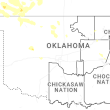
Oklahoma
| Local Time | Report Details |
|---|---|
| 6:05 PM CDT | Quarter sized hail reported near Tulsa, OK, 4.3 miles ESE of Tulsa, OK, report near 15th and lewis. relayed by media. |
| 11:10 PM CDT | May ranch mesone in woods county OK, 44 miles NNE of Woodward, OK |
| 11:15 PM CDT | Freedom mesone in woodward county OK, 25 miles NE of Woodward, OK |
| 12:10 AM CDT | Storm damage reported in woods county OK, 42.3 miles ENE of Woodward, OK |
| 1:10 AM CDT | Storm damage reported in grant county OK, 65.3 miles SSW of Wichita, KS |
| 1:15 AM CDT | Storm damage reported in grant county OK, 65.3 miles SSW of Wichita, KS |
| 2:28 AM CDT | Storm damage reported in kay county OK, 67.3 miles S of Wichita, KS |
Florida
| Local Time | Report Details |
|---|---|
| 7:18 PM CDT | Trees reported down on 8th ave in gracevill in jackson county FL, 65.2 miles NE of Miramar Beach, FL |
| 7:47 PM CDT | Tree down over sr-273 near chiple in washington county FL, 57.7 miles ENE of Miramar Beach, FL |
| 7:54 PM CDT | Power lines down over roadway near greenwoo in jackson county FL, 56.7 miles WNW of Tallahassee, FL |
Montana
| Local Time | Report Details |
|---|---|
| 8:30 PM MDT | Mesonet station mtsoo 16.0 sw bainville (mt dot in richland county MT, 36.4 miles WSW of Williston, ND |
Connect with Interactive Hail Maps