

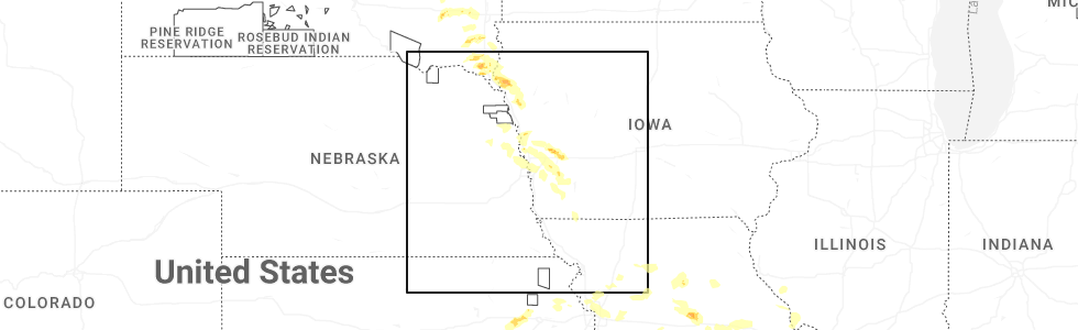
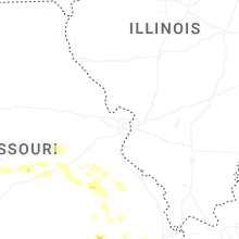
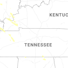
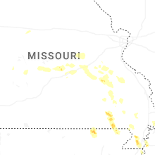
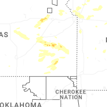
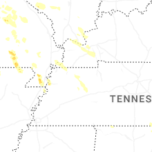
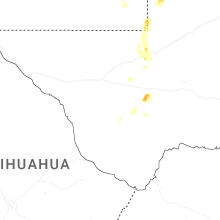
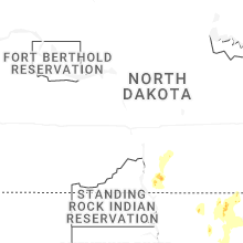
Hail Map for Sunday, May 31, 2026
Number of Impacted Households on 5/31/2026
0
Impacted by 1" or Larger Hail
0
Impacted by 1.75" or Larger Hail
0
Impacted by 2.5" or Larger Hail
Square Miles of Populated Area Impacted on 5/31/2026
0
Impacted by 1" or Larger Hail
0
Impacted by 1.75" or Larger Hail
0
Impacted by 2.5" or Larger Hail
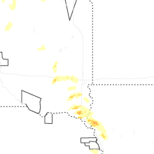
Cities Most Affected by Hail Storms of 5/31/2026
| Hail Size | Demographics of Zip Codes Affected | ||||||
|---|---|---|---|---|---|---|---|
| City | Count | Average | Largest | Pop Density | House Value | Income | Age |
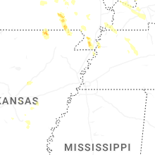
| Gridley, KS | 3 | 2.17 | 2.50 | 4 | $34k | $32.2k | 45.0 |
| Trimble, MO | 1 | 2.00 | 2.00 | 54 | $91k | $41.7k | 42.2 |
| Le Roy, KS | 1 | 1.75 | 1.75 | 9 | $42k | $32.6k | 45.8 |
| Cooter, MO | 1 | 1.75 | 1.75 | 0 | $52k | $29.4k | 35.1 |
| Olpe, KS | 1 | 1.75 | 1.75 | 5 | $72k | $40.6k | 42.9 |
Hail and Wind Damage Spotted on 5/31/2026
Filter by Report Type:Hail ReportsWind Reports
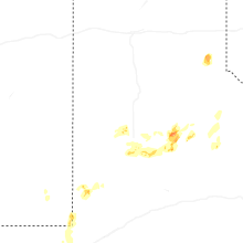
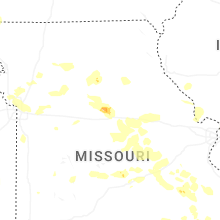
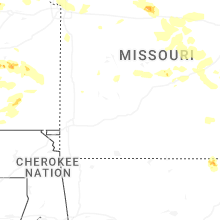
Missouri
| Local Time | Report Details |
|---|---|
| 12:30 PM CDT | Mshp reports a few trees down on highway 133 to the west of dixon. time estimated from rada in pulaski county MO, 40.6 miles NW of Salem, MO |
| 12:36 PM CDT | Mshp report of few trees down in the area of highway 28 and highway pp. time estimated from rada in pulaski county MO, 35.4 miles WNW of Salem, MO |
| 12:39 PM CDT | Mshp relayed report of a tree down on highway z near trophy lane. time estimated from rada in pulaski county MO, 32.1 miles WNW of Salem, MO |
| 2:00 PM CDT | Tree down across highway 3 in dent county MO, 20.1 miles E of Salem, MO |
| 2:16 PM CDT | Via facebook: numerous downed large tree branches along birch street. one large branch fell onto a metal outdoor pool and bent its frame. time estimated from rada in st. francois county MO, 57.2 miles E of Salem, MO |
| 2:25 PM CDT | Via facebook: large... healthy tree downed across driveway. tree pulled powerlines to the ground... but did not completely down the in st. francois county MO, 58.3 miles E of Salem, MO |
| 2:25 PM CDT | Via facebook: a large healthy tree downed across hwy aa near farmingto in st. francois county MO, 55.7 miles WNW of Cape Girardeau, MO |
| 2:30 PM CDT | Report of numerous trees down in the southern portion of st. francois county. time estimated from rada in st. francois county MO, 56.6 miles WNW of Cape Girardeau, MO |
| 2:35 PM CDT | 50-60 mph estimated winds with small limbs down. time estimated from rada in madison county MO, 47.5 miles WNW of Cape Girardeau, MO |
| 2:45 PM CDT | Via facebook: lots of trees and powerlines down in madison count in madison county MO, 45.6 miles WNW of Cape Girardeau, MO |
| 2:45 PM CDT | Via facebook: very large... healthy branches split from tree. some branches fell on a double wide residence and caused damage to gutters and roof. extent of damage unkn in madison county MO, 46.5 miles WNW of Cape Girardeau, MO |
| 2:50 PM CDT | Estimated 50-60 mph winds with small tree limbs down and debris on dd between oo and highway 6 in st. francois county MO, 50.3 miles WNW of Cape Girardeau, MO |
| 2:50 PM CDT | Extensive damage across farmstead. what appears to be a farm outbuilding was collapsed and a wooden beam was lodged into the top of a garage. debris all over yard. debr in madison county MO, 42.5 miles WNW of Cape Girardeau, MO |
| 3:22 PM CDT | Large tree limbs down. power outages 5 miles north of greenvill in wayne county MO, 51 miles W of Cape Girardeau, MO |
| 3:22 PM CDT | Trees blown down across county roads near patton. some tree tops blown ou in bollinger county MO, 29 miles WNW of Cape Girardeau, MO |
| 3:29 PM CDT | Power outages along county road 320 north of marble hil in bollinger county MO, 25.4 miles WNW of Cape Girardeau, MO |
| 3:39 PM CDT | Numerous trees and power lines down throughout cape girardeau county... including millersville... jackson... cape girardeau... and gordonsvill in cape girardeau county MO, 7.5 miles W of Cape Girardeau, MO |
| 3:42 PM CDT | Ping Pong Ball sized hail reported near Grandin, MO, 69.8 miles SE of Salem, MO, report received via social media. time estimated by radar. |
| 3:49 PM CDT | Tree limbs down 1.5 miles north of delt in cape girardeau county MO, 12.5 miles WSW of Cape Girardeau, MO |
| 3:53 PM CDT | Gust measured at kcgi aso in scott county MO, 5.4 miles SSW of Cape Girardeau, MO |
| 4:22 PM CDT | Quarter sized hail reported near Dexter, MO, 41.9 miles SSW of Cape Girardeau, MO |
| 4:27 PM CDT | A medium/large healthy tree downed on a home in fredericktow in madison county MO, 44.4 miles WNW of Cape Girardeau, MO |
| 4:29 PM CDT | Large... healthy tree downed across county road 212 near private drive 9277 (behind station at sawers landing in madison county MO, 44.4 miles WNW of Cape Girardeau, MO |
| 4:51 PM CDT | Quarter sized hail reported near East Prairie, MO, 38.9 miles SSE of Cape Girardeau, MO |
| 4:52 PM CDT | Quarter sized hail reported near Fairdealing, MO, 78.1 miles SW of Cape Girardeau, MO, report received via social media. time estimated via radar. |
| 5:05 PM CDT | Quarter sized hail reported near Oxly, MO, 80.2 miles SW of Cape Girardeau, MO |
| 6:05 PM CDT | Golf Ball sized hail reported near Cooter, MO, 63.5 miles NNE of Memphis, TN |
| 12:03 AM CDT | Storm damage reported in platte county MO, 9.5 miles NNW of Kansas City, MO |
| 12:51 AM CDT | Quarter sized hail reported near Trimble, MO, 25.3 miles N of Kansas City, MO, public report of quarter size hail. |
| 12:53 AM CDT | Quarter sized hail reported near Liberty, MO, 19.3 miles NNE of Kansas City, MO, report from mping: quarter (1.00 in.). |
| 12:55 AM CDT | Hen Egg sized hail reported near Trimble, MO, 25.3 miles N of Kansas City, MO |
| 1:20 AM CDT | Large tree blocking the roadway. report relayed via em. time estimated from rada in platte county MO, 5.5 miles NNW of Kansas City, MO |
| 1:34 AM CDT | Storm damage reported in clay county MO, 1.2 miles NNW of Kansas City, MO |
| 1:35 AM CDT | Several large branches down near swift st and 28th s in clay county MO, 3.2 miles N of Kansas City, MO |
| 1:35 AM CDT | Several large trees downed from storms overnight. time estimate via rada in clay county MO, 2.6 miles NNE of Kansas City, MO |
| 1:38 AM CDT | Kmkc airport reported a peak wind gust of 82 mph at 138 am cd in clay county MO, 1.2 miles NNW of Kansas City, MO |
| 1:46 AM CDT | Quarter sized hail reported near Kansas City, MO, 6.3 miles NNE of Kansas City, MO, report from mping: quarter (1.00 in.). |
| 2:33 AM CDT | Quarter sized hail reported near Lexington, MO, 37.4 miles E of Kansas City, MO, report from mping: quarter (1.00 in.). |
| 2:39 AM CDT | Personal weather station measured 58 mp in howard county MO, 23.5 miles NW of Columbia, MO |
| 3:00 AM CDT | Personal weather station measured 58 mp in lafayette county MO, 46.5 miles E of Kansas City, MO |
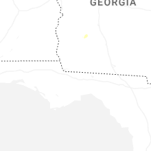
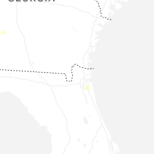
Georgia
| Local Time | Report Details |
|---|---|
| 4:04 PM EDT | Tree down along branchview stree in lee county GA, 78.5 miles W of Douglas, GA |
| 6:20 PM EDT | Tree down along highway 62 in calhoun county between leary and alban in calhoun county GA, 73.7 miles N of Tallahassee, FL |
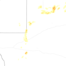
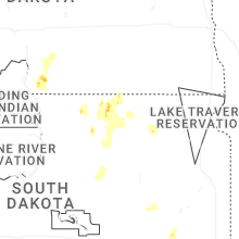
South Dakota
| Local Time | Report Details |
|---|---|
| 4:25 PM CDT | Quarter sized hail reported near Roscoe, SD, 36.8 miles W of Aberdeen, SD, mostly nickel to quarter size. |
| 4:28 PM CDT | Quarter sized hail reported near Roscoe, SD, 36.3 miles W of Aberdeen, SD, mostly dime size hail with the largest stones quarter size. time estimated by radar. |
| 5:07 PM CDT | Half Dollar sized hail reported near Howard, SD, 55.2 miles NW of Sioux Falls, SD |
| 5:30 PM CDT | Quarter sized hail reported near Emery, SD, 45.3 miles W of Sioux Falls, SD, very heavy rain along with penny to quarter sized hail. rainfall is already over 3 inches. |
| 6:20 PM CDT | Quarter sized hail reported near Leola, SD, 28.4 miles NW of Aberdeen, SD |
| 6:20 PM CDT | Quarter sized hail reported near Leola, SD, 27.5 miles NW of Aberdeen, SD |
| 6:45 PM CDT | No noticeable damage from the strong wind in mcpherson county SD, 29.5 miles NW of Aberdeen, SD |
| 7:26 PM CDT | Quarter sized hail reported near Humboldt, SD, 20.4 miles WNW of Sioux Falls, SD, in addition to hail up to the size of quarters... heavy rainfall was reported. |
| 7:33 PM CDT | Quarter sized hail reported near Hurley, SD, 29.8 miles SW of Sioux Falls, SD |
| 7:54 PM CDT | Quarter sized hail reported near Hurley, SD, 24.5 miles SW of Sioux Falls, SD |
| 8:45 PM CDT | Quarter sized hail reported near Davis, SD, 23.9 miles SW of Sioux Falls, SD |
| 9:15 PM CDT | Mesonet station llks2 eureka 13 en in mcpherson county SD, 53.3 miles WNW of Aberdeen, SD |
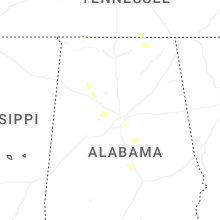
Alabama
| Local Time | Report Details |
|---|---|
| 5:13 PM CDT | Trees/phone lines and pole down at intersection of cr 47 and cr 61. time estimated from rada in lauderdale county AL, 6.3 miles NNE of Florence, AL |
| 5:24 PM CDT | 63 mph gust reported at the tower at the renaissance shoals resor in lauderdale county AL, 2.7 miles ENE of Florence, AL |
| 5:26 PM CDT | Multiple trees own along cr 24 near st florian near the railroad track in lauderdale county AL, 8.4 miles N of Florence, AL |
| 8:03 PM CDT | Tree down along cr 457 in pisgah. time estimated by rada in jackson county AL, 37.2 miles SW of Chattanooga, TN |
| 8:17 PM CDT | Tree down at the intersection of cr 4 and al hwy 65 in the holly tree communit in jackson county AL, 56 miles WSW of Chattanooga, TN |
| 8:22 PM CDT | Multiple trees down along cr 8. time estimated from rada in jackson county AL, 54.3 miles WSW of Chattanooga, TN |
| 8:40 PM CDT | Multiple trees down along al hwy 35 in scottsboro. time estimated by rada in jackson county AL, 47.3 miles SW of Chattanooga, TN |
Tennessee
| Local Time | Report Details |
|---|---|
| 5:28 PM CDT | Tree down on hwy 22 and bonnie hickman rd... damage to vehicl in obion county TN, 42 miles WNW of Mc Kenzie, TN |
| 6:12 PM CDT | Trees on powerlines and home in weakley county TN, 16.4 miles NW of Mc Kenzie, TN |
| 6:15 PM CDT | Large tree down on a home off of highway 5 in weakley county TN, 13.4 miles WNW of Mc Kenzie, TN |
| 6:31 PM CDT | Trees down along highway 19 in carroll county TN, 6.6 miles SSW of Mc Kenzie, TN |
| 6:46 PM CDT | Tree down on terry roa in carroll county TN, 15.1 miles SSW of Mc Kenzie, TN |
Texas
| Local Time | Report Details |
|---|---|
| 6:44 PM CDT | Quarter sized hail reported near Spur, TX, 44.3 miles E of Lubbock, TX |
| 6:48 PM CDT | Storm damage reported in garza county TX, 39 miles SE of Lubbock, TX |
| 7:47 PM CDT | Storm damage reported in cottle county TX, 36.8 miles S of Childress, TX |
| 10:25 PM CDT | Storm damage reported in lubbock county TX, 11.3 miles W of Lubbock, TX |
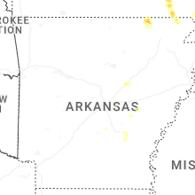
Arkansas
| Local Time | Report Details |
|---|---|
| 7:08 PM CDT | Quarter sized hail reported near Scott, AR, 10.5 miles ESE of Little Rock, AR |
| 8:17 PM CDT | Quarter sized hail reported near Searcy, AR, 46.3 miles NE of Little Rock, AR |
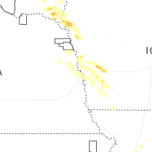
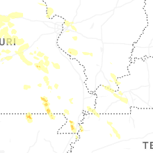
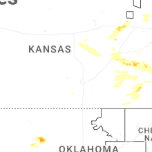
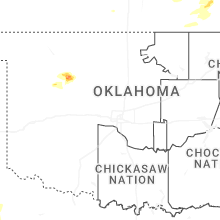
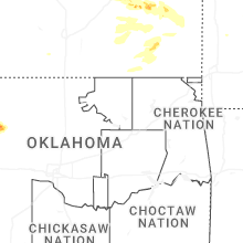
Kansas
| Local Time | Report Details |
|---|---|
| 8:38 PM CDT | Half Dollar sized hail reported near Cottonwood Falls, KS, 63.8 miles NE of Wichita, KS, report from mping: half dollar (1.25 in.). |
| 9:04 PM CDT | Golf Ball sized hail reported near Olpe, KS, 56.1 miles NW of Chanute, KS |
| 10:31 PM CDT | Golf Ball sized hail reported near Gridley, KS, 40.5 miles NW of Chanute, KS, report from mping. |
| 10:50 PM CDT | Hen Egg sized hail reported near Gridley, KS, 35.8 miles NW of Chanute, KS, resent. report from mping: hen egg+ (2.25 in.). |
| 10:52 PM CDT | Tennis Ball sized hail reported near Gridley, KS, 37.1 miles NW of Chanute, KS, emergency manager relayed photo of estimated tennis ball size hail in gridley. time estimated from radar. |
| 11:02 PM CDT | Quarter sized hail reported near Emporia, KS, 57.5 miles SSE of Manhattan, KS, spotter network report. |
| 11:26 PM CDT | Golf Ball sized hail reported near Le Roy, KS, 32.8 miles NNW of Chanute, KS, report from mping: golf ball (1.75 in.). |
| 11:43 PM CDT | Ping Pong Ball sized hail reported near Emporia, KS, 58.3 miles NW of Chanute, KS, report from mping: ping pong ball (1.50 in.). |
| 12:24 AM CDT | Also getting hail but cant see what siz in morris county KS, 25.5 miles SSE of Manhattan, KS |
| 12:27 AM CDT | Quarter sized hail reported near Neosho Falls, KS, 23.4 miles NNW of Chanute, KS |
Iowa
| Local Time | Report Details |
|---|---|
| 11:56 PM CDT | Quarter sized hail reported near Woodbine, IA, 35.2 miles NNE of Omaha, NE |
| 2:08 AM CDT | Personal weather station measured wind gus in pottawattamie county IA, 24.9 miles E of Omaha, NE |
Connect with Interactive Hail Maps